
罗田县 topographic map
Interactive map
Click on the map to display elevation.
About this map
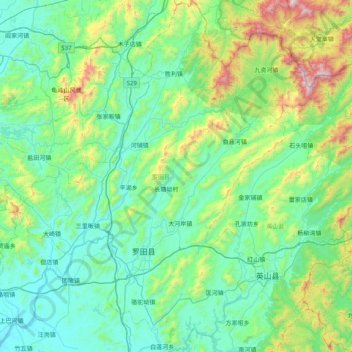
Name: 罗田县 topographic map, elevation, terrain.
Location: 罗田县, 黄冈市, 湖北省, 中国 (30.58694 115.10352 31.27394 115.77374)
Average elevation: 1,053 ft
Minimum elevation: 75 ft
Maximum elevation: 5,538 ft
罗田县盛产的板栗颇有名气。与英山县交界处有大别山脉主峰“天堂寨”(海拔1729.13米)。三里畈附近有温泉。
Other topographic maps
Click on a map to view its topography, its elevation and its terrain.