
Warren County topographic map
Interactive map
Click on the map to display elevation.
About this map
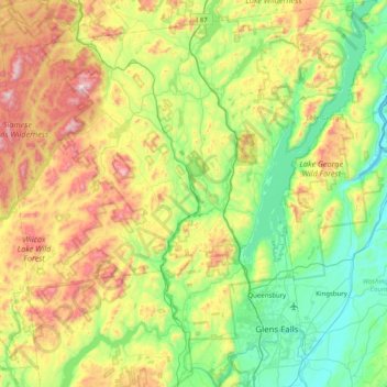
Name: Warren County topographic map, elevation, terrain.
Location: Warren County, New York, United States (43.22224 -74.21443 43.80370 -73.43657)
Average elevation: 1,168 ft
Minimum elevation: 82 ft
Maximum elevation: 3,537 ft
Warren County is situated in the eastern portion of New York State in the Adirondack Mountains. The eastern border is Washington County. The highest peak in the county is Gore Mountain at an elevation of 3,198 feet (975 m). It is typically included as the northern part of the Capital District although it is sometimes included as part of the North Country.
Other topographic maps
Click on a map to view its topography, its elevation and its terrain.
Manhattan
United States > New York > New York County > New York
Manhattan, New York County, New York, United States
Average elevation: 52 ft
Manhattan Island
United States > New York > New York
Manhattan Island, New York, United States
Average elevation: 56 ft
Dutchess County
Dutchess County, New York, United States
Average elevation: 587 ft
Adirondack Park
Adirondack Park, New York, United States
Average elevation: 1,217 ft
Brooklyn
United States > New York > New York
Brooklyn, Kings County, New York, United States
Average elevation: 30 ft
City of Syracuse
United States > New York > Onondaga County
City of Syracuse, Onondaga County, New York, United States
Average elevation: 564 ft
Bush Terminal Park
United States > New York > New York
Bush Terminal Park, Brooklyn, Kings County, New York, United States
Average elevation: 26 ft
Town of Huntington
United States > New York > Suffolk County
Town of Huntington, Suffolk County, New York, United States
Average elevation: 98 ft
Finger Lakes National Forest
United States > New York > Schuyler County > Town of Hector
Finger Lakes National Forest, Town of Hector, Schuyler County, New York, 14818, United States
Average elevation: 1,168 ft
Putnam County
Putnam County, New York, United States
Average elevation: 554 ft
Westchester County
Westchester County, New York, United States
Average elevation: 312 ft
Village of Tuckahoe
United States > New York > Westchester County > Town of Eastchester
Village of Tuckahoe, Town of Eastchester, Westchester County, New York, United States
Average elevation: 187 ft
City of Schenectady
United States > New York > Schenectady County
City of Schenectady, Schenectady County, New York, 12345, United States
Average elevation: 328 ft
Oneida County
Oneida County, New York, United States
Average elevation: 1,086 ft
Rensselaer County
Rensselaer County, New York, United States
Average elevation: 784 ft
Buffalo
United States > New York > Erie County
Buffalo, Erie County, New York, United States
Average elevation: 607 ft
City of Ithaca
United States > New York > Tompkins County
City of Ithaca, Tompkins County, New York, United States
Average elevation: 640 ft
City of Binghamton
United States > New York > Broome County
City of Binghamton, Dickinson, Broome County, New York, 13905, United States
Average elevation: 1,053 ft
The Bronx
United States > New York > New York
The Bronx, New York, United States
Average elevation: 75 ft
Monroe County
Monroe County, New York, United States
Average elevation: 400 ft
Saratoga County
Saratoga County, New York, United States
Average elevation: 715 ft
East Hampton
United States > New York > Suffolk County > East Hampton > Village of East Hampton
East Hampton, Village of East Hampton, Suffolk County, New York, 11937, United States
Average elevation: 39 ft
Montauk
United States > New York > Suffolk County > Town of East Hampton
Montauk, Town of East Hampton, Suffolk County, New York, 11954, United States
Average elevation: 7 ft
City of Rye
United States > New York > Westchester County
City of Rye, Westchester County, New York, United States
Average elevation: 30 ft
City of Yonkers
United States > New York > Westchester County
City of Yonkers, Westchester County, New York, United States
Average elevation: 190 ft
Cortland County
Cortland County, New York, United States
Average elevation: 1,486 ft
Upper West Side
United States > New York > New York
Upper West Side, Manhattan Community Board 7, Manhattan, New York County, New York, United States
Average elevation: 75 ft
Tompkins County
Tompkins County, New York, United States
Average elevation: 1,237 ft
Columbia County
Columbia County, New York, United States
Average elevation: 643 ft
Central Park
United States > New York > New York County > New York
Central Park, New York County, New York, United States
Average elevation: 85 ft
Roosevelt Island
United States > New York > New York County > New York
Roosevelt Island, Manhattan, New York County, New York, 10044, United States
Average elevation: 43 ft
Ulster County
Ulster County, New York, United States
Average elevation: 1,125 ft
Millsite Lake
United States > New York > Jefferson County > Town of Theresa
Millsite Lake, Town of Theresa, Jefferson County, New York, United States
Average elevation: 351 ft
Village of Otego
United States > New York > Otsego County
Village of Otego, Town of Otego, Otsego County, New York, United States
Average elevation: 1,194 ft
Saratoga Springs
United States > New York > Saratoga County > Saratoga Springs
Saratoga Springs, City of Saratoga Springs, Saratoga County, New York, 12866, United States
Average elevation: 528 ft
Village of Scarsdale
United States > New York > Westchester County
Village of Scarsdale, Westchester County, New York, 10583, United States
Average elevation: 249 ft
Lake George
United States > New York > Warren County > Town of Bolton
Lake George, Town of Bolton, Warren County, New York, United States
Average elevation: 810 ft
Orange County
Orange County, New York, United States
Average elevation: 636 ft
Troy
United States > New York > Rensselaer County
Troy, Rensselaer County, New York, 12181, United States
Average elevation: 449 ft
Staten Island
United States > New York > New York
Staten Island, Richmond County, New York, United States
Average elevation: 30 ft
Town of Vestal
United States > New York > Broome County
Town of Vestal, Broome County, New York, United States
Average elevation: 1,220 ft
City of Troy
United States > New York > Rensselaer County
City of Troy, Rensselaer County, New York, United States
Average elevation: 266 ft
Petrolia
United States > New York > Allegany County
Petrolia, Town of Scio, Allegany County, New York, 14707, United States
Average elevation: 2,047 ft
Town of Sangerfield
United States > New York > Oneida County
Town of Sangerfield, Oneida County, New York, United States
Average elevation: 1,430 ft
Godeffroy
United States > New York > Orange County
Godeffroy, Town of Deerpark, Orange County, New York, 12739, United States
Average elevation: 705 ft
Town of Shelter Island
United States > New York > Suffolk County
Town of Shelter Island, Suffolk County, New York, United States
Average elevation: 10 ft