
Make a donation
Gear up for your next adventure:
As an Amazon Associate, this site earns from qualifying purchases at no extra cost to you.
Haselünne topographic map
Click on the map to display elevation.
Make a donation
Gear up for your next adventure:
As an Amazon Associate, this site earns from qualifying purchases at no extra cost to you.
About this map
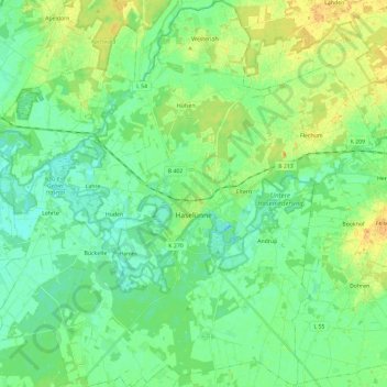
Name: Haselünne topographic map, elevation, terrain.
Location: Haselünne, Landkreis Emsland, Niedersachsen, 49740, Deutschland (52.60852 7.35983 52.75081 7.59419)
Average elevation: 72 ft
Minimum elevation: 39 ft
Maximum elevation: 128 ft
Make a donation
Gear up for your next adventure:
As an Amazon Associate, this site earns from qualifying purchases at no extra cost to you.
Other topographic maps
Click on a map to view its topography, its elevation and its terrain.
Rühlerfeld
Deutschland > Niedersachsen > Landkreis Emsland
Rühlerfeld liegt im Westen des Landkreises nahe der Grenze zu den Niederlanden zwischen Rühle und Rühlermoor. Das Stadtzentrum von Meppen liegt etwa 8 km (Luftlinie) östlich von Rühlerfeld, das Zentrum von Twist liegt etwa gleich weit westlich von Rühlerfeld entfernt. Das Dorf liegt auf einer Höhe von…
Average elevation: 62 ft
Tunxdorf
Deutschland > Niedersachsen > Landkreis Emsland > Papenburg > Nenndorf
Average elevation: 7 ft
Make a donation
Gear up for your next adventure:
As an Amazon Associate, this site earns from qualifying purchases at no extra cost to you.
Harenerfähr
Deutschland > Niedersachsen > Landkreis Emsland > Haren (Ems) > Raken
Average elevation: 43 ft
Make a donation
Gear up for your next adventure:
As an Amazon Associate, this site earns from qualifying purchases at no extra cost to you.
Schwartenberg
Deutschland > Niedersachsen > Landkreis Emsland > Spahnharrenstätte
Average elevation: 105 ft
Make a donation
Gear up for your next adventure:
As an Amazon Associate, this site earns from qualifying purchases at no extra cost to you.
Herbrum Siedlung
Deutschland > Niedersachsen > Landkreis Emsland > Aschendorf
Average elevation: 16 ft
Haren (Ems)
Deutschland > Niedersachsen > Landkreis Emsland > Haren (Ems) > Haren (Ems)
Average elevation: 49 ft
Schwefingen
Deutschland > Niedersachsen > Landkreis Emsland > Meppen > Schwefingen
Average elevation: 59 ft
Make a donation
Gear up for your next adventure:
As an Amazon Associate, this site earns from qualifying purchases at no extra cost to you.
Surwold
Deutschland > Niedersachsen > Landkreis Emsland > Surwold > Surwold
Der südlich gelegene Ortsteil Börgerwald mit rd. 1.800 Einwohnern liegt am nördlichen Rande des hügeligen und waldreichen Hümmlings, 5–42 Meter über dem Meeresspiegel. Die Nutzung der Landschaft ist durch die Landwirtschaft geprägt. Bemerkenswert ist die „Serpentine“ der L51 im Bereich der…
Average elevation: 36 ft
Herzlake
Deutschland > Niedersachsen > Landkreis Emsland > Herzlake > Herzlake
Herzlake liegt nur etwas nordwestlich der Ankumer Höhe am Fluss Hase, zwischen Haselünne und Löningen. Östlich des Orts endet das Hase-Binnendelta mit der Vereinigung der Großen Hase und des Hahnenmoorkanals als Verlängerung der Kleinen Hase; westlich von ihm mündet die Südradde in die Hase.
Average elevation: 79 ft
Make a donation
Gear up for your next adventure:
As an Amazon Associate, this site earns from qualifying purchases at no extra cost to you.
Baccum
Deutschland > Niedersachsen > Landkreis Emsland > Lingen (Ems)
Die Ortschaft Baccum liegt im Süden des Landkreises Emsland, östlich von Lingen auf einer Höhe von 40 m ü. NN. Der Ort war früher eine Gemeinde und gehört heute zur Stadt Lingen (Ems). Dem ehemaligen Kirchdorf Baccum waren die Gemeinden und Bauerschaften Ramsel und Münnigbüren zugeordnet: Alle drei…
Average elevation: 138 ft
Make a donation
Gear up for your next adventure:
As an Amazon Associate, this site earns from qualifying purchases at no extra cost to you.
Make a donation
Gear up for your next adventure:
As an Amazon Associate, this site earns from qualifying purchases at no extra cost to you.
Rütenbrock
Deutschland > Niedersachsen > Landkreis Emsland > Haren (Ems)
Rütenbrock partizipiert von der starken Kaufkraft der nahen niederländischen Provinzen Drenthe mit der Stadt Emmen und Groningen mit den Gemeinden Vlagtwedde und Ter Apel. Der niedrigere deutsche Mehrwertsteuersatz zieht zum günstigeren Einkaufen und Tanken nach Rütenbrock. Zudem lassen sich viele…
Average elevation: 43 ft
Make a donation
Gear up for your next adventure:
As an Amazon Associate, this site earns from qualifying purchases at no extra cost to you.
Landegge
Deutschland > Niedersachsen > Landkreis Emsland > Haren (Ems) > Emen
Average elevation: 36 ft
Make a donation
Gear up for your next adventure:
As an Amazon Associate, this site earns from qualifying purchases at no extra cost to you.
Bersede
Deutschland > Niedersachsen > Landkreis Emsland > Haren (Ems) > Wesuwe
Average elevation: 49 ft
Make a donation
Gear up for your next adventure:
As an Amazon Associate, this site earns from qualifying purchases at no extra cost to you.
Make a donation
Gear up for your next adventure:
As an Amazon Associate, this site earns from qualifying purchases at no extra cost to you.
Make a donation
Gear up for your next adventure:
As an Amazon Associate, this site earns from qualifying purchases at no extra cost to you.
Herbrum
Deutschland > Niedersachsen > Landkreis Emsland > Papenburg
Herbrum liegt im Norden des Landkreises am rechten (östlichen) Ufer der Ems in einer Höhe von 2–12 m über NHN. Das Stadtzentrum von Papenburg liegt etwa 8 km nordöstlich von Herbrum, die Kreisstadt Meppen liegt etwa 38 km südlich. Die Ortslage umfasst eine Fläche von 17,57 km².
Average elevation: 13 ft
Nienhaus
Deutschland > Niedersachsen > Landkreis Emsland > Papenburg > Herbrum
Average elevation: 13 ft
Make a donation
Gear up for your next adventure:
As an Amazon Associate, this site earns from qualifying purchases at no extra cost to you.
Schloss Dankern
Deutschland > Niedersachsen > Landkreis Emsland > Haren (Ems) > Altharen > Dankern
Average elevation: 39 ft
Make a donation
Gear up for your next adventure:
As an Amazon Associate, this site earns from qualifying purchases at no extra cost to you.
Make a donation
Gear up for your next adventure:
As an Amazon Associate, this site earns from qualifying purchases at no extra cost to you.
Bramsche
Deutschland > Niedersachsen > Landkreis Emsland > Lingen (Ems)
In Wesel, beiderseits der Bundesstraße 70 in Höhe der Mülldeponie Venneberg, befand sich der Militärflugplatz Plantlünne/Wesel mit der III./Jagdgeschwader 26. Zu Beginn des Zweiten Weltkrieges war der Flugplatz, auf dem 60 bis 120 Flugzeuge standen, einsatzfähig. Der Flughafen wurde von Strafgefangenen…
Average elevation: 108 ft
Make a donation
Gear up for your next adventure:
As an Amazon Associate, this site earns from qualifying purchases at no extra cost to you.
Hahnentange
Deutschland > Niedersachsen > Landkreis Emsland > Haren (Ems) > Hahnentange
Average elevation: 39 ft
Lähden
Deutschland > Niedersachsen > Landkreis Emsland > Lähden > Lähden
Am 1. Februar 1971 kam es zur Eingliederung der Gemeinden Holte-Lastrup, Ahmsen, Herßum und Vinnen in die Gemeinde Lähden. Zuvor gab es einen erbitterten Kampf um den Schulstandort, den Namen und den Sitz der Gemeinde. Der Schulzweckverband setzte sich für Holte-Lastrup als geschichtlich gewachsener…
Average elevation: 98 ft
Make a donation
Gear up for your next adventure:
As an Amazon Associate, this site earns from qualifying purchases at no extra cost to you.
Nenndorf
Deutschland > Niedersachsen > Landkreis Emsland > Papenburg > Nenndorf
Average elevation: 7 ft
Wehrtannen
Deutschland > Niedersachsen > Landkreis Emsland > Dersum > Wehrtannen
Average elevation: 20 ft
Make a donation
Gear up for your next adventure:
As an Amazon Associate, this site earns from qualifying purchases at no extra cost to you.
Make a donation
Gear up for your next adventure:
As an Amazon Associate, this site earns from qualifying purchases at no extra cost to you.
Aschendorfer Moor
Deutschland > Niedersachsen > Landkreis Emsland > Papenburg
Average elevation: 26 ft
Make a donation
Gear up for your next adventure:
As an Amazon Associate, this site earns from qualifying purchases at no extra cost to you.
Herbrum
Deutschland > Niedersachsen > Landkreis Emsland > Papenburg
Herbrum liegt im Norden des Landkreises am rechten (östlichen) Ufer der Ems in einer Höhe von 2–12 m über NHN. Das Stadtzentrum von Papenburg liegt etwa 8 km nordöstlich von Herbrum, die Kreisstadt Meppen liegt etwa 38 km südlich. Die Ortslage umfasst eine Fläche von 17,57 km².
Average elevation: 13 ft