
Make a donation
Gear up for your next adventure:
As an Amazon Associate, this site earns from qualifying purchases at no extra cost to you.
Batman topographic map
Click on the map to display elevation.
Make a donation
Gear up for your next adventure:
As an Amazon Associate, this site earns from qualifying purchases at no extra cost to you.
Batman
The province occupies an area of 4,477 km2 (1,729 sq mi). It lies in a mountainous area with the average elevation of 550 meters which contains several thousands of caves. The tallest mountains are Sason Dağları (2500 m), Meleto (2967 m), Kuşaklı Dağı (1947 m), Avcı Dağı (2121 m), Meydanok Tepesi (2042 m), Kortepe (2082 m) and Raman Dağı (1288 m). Several rivers (Turkish: Çay or Nehir) flow through the province, including Tigris, Batman, Sason and Garzan. The 115 km (71 mi) long Batman River flowing approximately from north to south forms a natural border between the Batman Province and Diyarbakır Province lying to the west. The historic Malabadi Bridge (built in 1146–1147) crosses the river near the town of Silvan. The Tigris flows from west to east, merges with the Batman River and exits the province. The Garzan River flowing from north to south enters the Tigris and separates Batman from the Siirt Province lying to the east. The province is also of interest from an archaeological point of view. Sights include the Imam Abdullah Dervish monastery, the bridge of Camiü‘r Rızk and Hasankeyf.
Make a donation
Gear up for your next adventure:
As an Amazon Associate, this site earns from qualifying purchases at no extra cost to you.
About this map
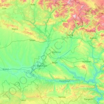
Name: Batman topographic map, elevation, terrain.
Location: Batman, Southeastern Anatolia Region, Turkey (37.49516 40.98644 38.54212 41.82192)
Average elevation: 3,087 ft
Minimum elevation: 1,335 ft
Maximum elevation: 9,610 ft
Make a donation
Gear up for your next adventure:
As an Amazon Associate, this site earns from qualifying purchases at no extra cost to you.
Other topographic maps
Click on a map to view its topography, its elevation and its terrain.
Istanbul
Istanbul, located in northwestern Turkey, is a city that is uniquely situated across two continents, Europe and Asia, divided by the Bosphorus Strait. The city’s topography is characterized by a complex blend of hills, valleys, and coastal plains, which create a varied and scenic landscape. The European side…
Average elevation: 187 ft
Ankara
Ankara has a cold semi-arid climate (Köppen climate classification: BSk). Under the Trewartha climate classification, Ankara has a temperate humid continental climate (Dc). Due to its elevation and inland location, Ankara has cold and snowy winters, and hot and dry summers. Rainfall occurs mostly during the…
Average elevation: 3,550 ft
Istanbul
Istanbul, located in northwestern Turkey, is a city that is uniquely situated across two continents, Europe and Asia, divided by the Bosphorus Strait. The city’s topography is characterized by a complex blend of hills, valleys, and coastal plains, which create a varied and scenic landscape. The European side…
Average elevation: 187 ft
Anatolia
Anatolia (Turkish: Anadolu), also known as Asia Minor, is a large peninsula or a region in Turkey, constituting most of its contemporary territory. Geographically, the Anatolian region is bounded by the Mediterranean Sea to the south, the Aegean Sea to the west, the Turkish Straits to the north-west, and the…
Average elevation: 3,123 ft
Make a donation
Gear up for your next adventure:
As an Amazon Associate, this site earns from qualifying purchases at no extra cost to you.
Istanbul
Istanbul, located in northwestern Turkey, is a city that is uniquely situated across two continents, Europe and Asia, divided by the Bosphorus Strait. The city’s topography is characterized by a complex blend of hills, valleys, and coastal plains, which create a varied and scenic landscape. The European side…
Average elevation: 187 ft
Antalya
While the city itself only has modest elevation changes, Antalya has high mountains in all directions to its interior. With moisture being trapped, the local climate thus has high winter rainfall, while the interior bay setting result in very hot summers for a coastal city.
Average elevation: 384 ft
Make a donation
Gear up for your next adventure:
As an Amazon Associate, this site earns from qualifying purchases at no extra cost to you.
Ankara
Ankara has a cold semi-arid climate (Köppen climate classification: BSk). Under the Trewartha climate classification, Ankara has a temperate humid continental climate (Dc). Due to its elevation and inland location, Ankara has cold and snowy winters, and hot and dry summers. Rainfall occurs mostly during the…
Average elevation: 3,550 ft
Make a donation
Gear up for your next adventure:
As an Amazon Associate, this site earns from qualifying purchases at no extra cost to you.
Mount Ararat
Mount Ararat, officially Mount Ağrı, also known as Masis, is a snow- capped and dormant compound volcano in easternmost Turkey. It consists of two major volcanic cones: Greater Ararat and Little Ararat. Greater Ararat is the highest peak in Turkey and the Armenian highlands with an elevation of 5,137 m…
Average elevation: 15,033 ft
Ankara
Ankara has a cold semi-arid climate (Köppen climate classification: BSk). Under the Trewartha climate classification, Ankara has a temperate humid continental climate (Dc). Due to its elevation and inland location, Ankara has cold and snowy winters, and hot and dry summers. Rainfall occurs mostly during the…
Average elevation: 3,550 ft
Make a donation
Gear up for your next adventure:
As an Amazon Associate, this site earns from qualifying purchases at no extra cost to you.
Taurus Mountains
The mountains have a Mediterranean climate, with dry summers and rainy winters. Temperatures vary with elevation, with warm winters on the lower coastal slopes and cold winters in the high mountains and in the interior.
Average elevation: 2,717 ft
Babadağ
The mountain has a principal summit at an elevation of 1,969 metres (6,460 ft) and a second one called "Karatepe" at an elevation of 1,400 metres (4,593 ft). These two summits face each other and are separated by a flood valley, which led to the term "mountain range" to be used in some sources in association…
Average elevation: 4,800 ft
Make a donation
Gear up for your next adventure:
As an Amazon Associate, this site earns from qualifying purchases at no extra cost to you.
Mount Ararat
Mount Ararat is a snow-capped and dormant compound volcano in the extreme east of Turkey. It consists of two major volcanic cones: Greater Ararat and Little Ararat. Greater Ararat is the highest peak in Turkey and the Armenian Highland with an elevation of 5,137 m (16,854 ft); Little Ararat's elevation is…
Average elevation: 15,033 ft
Make a donation
Gear up for your next adventure:
As an Amazon Associate, this site earns from qualifying purchases at no extra cost to you.
Gaziantep
The plan introduced several important changes to the city's transportation network. One of the most important was the addition of a rail line to connect Gaziantep to the national rail system. Up to now, Turkish railway construction had ignored Gaziantep (partly because of its mountainous surroundings); a…
Average elevation: 2,887 ft
Erciyes Dağı
The climate of the region is influenced by topography, with the Taurus and Kaçkar Mountains blocking the entry of moisture into Anatolia. Summers are dry and hot and winters snowy and cold; in Kayseri, summer temperatures are about 19 °C (66 °F) and winter temperature about 0 °C (32 °F). Precipitation at…
Average elevation: 10,938 ft
Make a donation
Gear up for your next adventure:
As an Amazon Associate, this site earns from qualifying purchases at no extra cost to you.
Cappadocia
The area was featured in several films due to its topography. The 1983 Italian/French/Turkish film Yor, the Hunter from the Future was filmed in Cappadocia. The region was used for the 1989 science fiction film Slipstream to depict a cult of wind worshippers. In 2010 and early 2011, the film Ghost Rider:…
Average elevation: 3,829 ft
Akyaka
Akyaka is a neighbourhood of the municipality and district of Ula, Muğla Province, Turkey. Its population is 3,147 (2022). Before the 2013 reorganisation, it was a town (belde). The town is situated at the far end of the Gulf of Gökova, at the start of the fertile Gökova plain, and is a rising center for…
Average elevation: 873 ft
Make a donation
Gear up for your next adventure:
As an Amazon Associate, this site earns from qualifying purchases at no extra cost to you.
Ankara
Ankara has a cold semi-arid climate (Köppen climate classification: BSk). Under the Trewartha climate classification, Ankara has a temperate humid continental climate (Dc). Due to its elevation and inland location, Ankara has cold and snowy winters, and hot and dry summers. Rainfall occurs mostly during the…
Average elevation: 3,550 ft
Make a donation
Gear up for your next adventure:
As an Amazon Associate, this site earns from qualifying purchases at no extra cost to you.
Make a donation
Gear up for your next adventure:
As an Amazon Associate, this site earns from qualifying purchases at no extra cost to you.
Make a donation
Gear up for your next adventure:
As an Amazon Associate, this site earns from qualifying purchases at no extra cost to you.
Denizli
Denizli has a Mediterranean climate (Köppen: Csa or Trewartha: Cs), with hot, dry summers and mild to cool, rainy winters. The inland areas, like Çardak, Bozkurt, Çivril, and Çal districts/counties of the province are cooler and have a higher elevation than the seaside, western part of the Province.…
Average elevation: 2,438 ft
Make a donation
Gear up for your next adventure:
As an Amazon Associate, this site earns from qualifying purchases at no extra cost to you.
Make a donation
Gear up for your next adventure:
As an Amazon Associate, this site earns from qualifying purchases at no extra cost to you.
Make a donation
Gear up for your next adventure:
As an Amazon Associate, this site earns from qualifying purchases at no extra cost to you.
Make a donation
Gear up for your next adventure:
As an Amazon Associate, this site earns from qualifying purchases at no extra cost to you.
Denizli
Denizli is an industrial city in the southwestern part of Turkey and the eastern end of the alluvial valley formed by the river Büyük Menderes, where the plain reaches an elevation of about three hundred and fifty metres (1,148 ft). Denizli is located in the country's Aegean Region.
Average elevation: 2,438 ft
Make a donation
Gear up for your next adventure:
As an Amazon Associate, this site earns from qualifying purchases at no extra cost to you.
Make a donation
Gear up for your next adventure:
As an Amazon Associate, this site earns from qualifying purchases at no extra cost to you.
Cappadocia
Cappadocia lies in central Anatolia, in the heartland of what is now Turkey. The relief consists of a high plateau over 1,000 m in altitude that is pierced by volcanic peaks, with Mount Erciyes (ancient Argaeus) near Kayseri (ancient Caesarea) being the tallest at 3,916 m. The boundaries of historical…
Average elevation: 3,829 ft
Adana
Adana is located on the 37th parallel north at the northeastern edge of the Mediterranean, where it serves as the gateway to the Cilicia plain. This large stretch of flat, fertile land lies southeast of the Taurus Mountains. From Adana, crossing Cilicia westwards, the road from Tarsus enters the foothills of…
Average elevation: 200 ft
Istanbul
Istanbul, located in northwestern Turkey, is a city that is uniquely situated across two continents, Europe and Asia, divided by the Bosphorus Strait. The city’s topography is characterized by a complex blend of hills, valleys, and coastal plains, which create a varied and scenic landscape. The European side…
Average elevation: 187 ft
Make a donation
Gear up for your next adventure:
As an Amazon Associate, this site earns from qualifying purchases at no extra cost to you.
Make a donation
Gear up for your next adventure:
As an Amazon Associate, this site earns from qualifying purchases at no extra cost to you.
Mount Judi
The Arabic word al-Jūdiyy (ٱلْجُودِيّ), originates from the Syriac word Gudo (ܓܘܕܐ) meaning "Mounds" or "Elevations". The relation of some of the spellings is clear. The origin of Judi is less clear. It is usually interpreted as a corrupted version of the same name, via Al-Gurdi (Reynolds 2004).…
Average elevation: 6,247 ft
Make a donation
Gear up for your next adventure:
As an Amazon Associate, this site earns from qualifying purchases at no extra cost to you.
Make a donation
Gear up for your next adventure:
As an Amazon Associate, this site earns from qualifying purchases at no extra cost to you.
Make a donation
Gear up for your next adventure:
As an Amazon Associate, this site earns from qualifying purchases at no extra cost to you.
Ankara
Ankara has a cold semi-arid climate (Köppen climate classification: BSk). Under the Trewartha climate classification, Ankara has a temperate humid continental climate (Dc). Due to its elevation and inland location, Ankara has cold and snowy winters, and hot and dry summers. Rainfall occurs mostly during the…
Average elevation: 3,550 ft
Make a donation
Gear up for your next adventure:
As an Amazon Associate, this site earns from qualifying purchases at no extra cost to you.
Make a donation
Gear up for your next adventure:
As an Amazon Associate, this site earns from qualifying purchases at no extra cost to you.
Erzurum
Six kilometres to the south of the center of Erzurum is an important skiing center on the Palandöken Mountain range. There are several ski runs; the south ski run is eight km long, while the north ski run is intended for advanced skiers. The summit of Mt. Palandöken, which is called Büyük Ejder (Great…
Average elevation: 6,854 ft
Make a donation
Gear up for your next adventure:
As an Amazon Associate, this site earns from qualifying purchases at no extra cost to you.