
Make a donation
Gear up for your next adventure:
As an Amazon Associate, this site earns from qualifying purchases at no extra cost to you.
Avilés topographic map
Click on the map to display elevation.
Make a donation
Gear up for your next adventure:
As an Amazon Associate, this site earns from qualifying purchases at no extra cost to you.
Avilés
The town occupies the flattest land in the municipality, partially in a land that belonged to the sea, surrounded by small promontories, all of them having an altitude of less than 140 metres. Situated in the Avilés estuary, in the Northern Central area of the Asturian coast, west of Peñas Cape, is its national seaport.
Make a donation
Gear up for your next adventure:
As an Amazon Associate, this site earns from qualifying purchases at no extra cost to you.
About this map
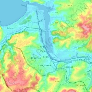
Name: Avilés topographic map, elevation, terrain.
Location: Avilés, Asturias, Spain (43.53054 -5.95379 43.59600 -5.87675)
Average elevation: 138 ft
Minimum elevation: -16 ft
Maximum elevation: 443 ft
Make a donation
Gear up for your next adventure:
As an Amazon Associate, this site earns from qualifying purchases at no extra cost to you.
Other topographic maps
Click on a map to view its topography, its elevation and its terrain.
Make a donation
Gear up for your next adventure:
As an Amazon Associate, this site earns from qualifying purchases at no extra cost to you.
Make a donation
Gear up for your next adventure:
As an Amazon Associate, this site earns from qualifying purchases at no extra cost to you.
Make a donation
Gear up for your next adventure:
As an Amazon Associate, this site earns from qualifying purchases at no extra cost to you.
Arriondas / Les Arriondes
Spain > Asturias > Parres > Arriondas / Les Arriondes
Average elevation: 614 ft
Make a donation
Gear up for your next adventure:
As an Amazon Associate, this site earns from qualifying purchases at no extra cost to you.