Dithmarschen topographic map
Click on the map to display elevation.
About this map
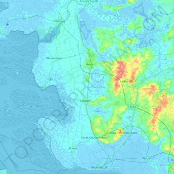
Name: Dithmarschen topographic map, elevation, terrain.
Location: Dithmarschen, Schleswig-Holstein, Germany (53.87754 8.67970 54.37878 9.44437)
Average elevation: 16 ft
Minimum elevation: -16 ft
Maximum elevation: 249 ft
Other topographic maps
Click on a map to view its topography, its elevation and its terrain.


Potsdam
Germany > Schleswig-Holstein > Kreis Schleswig-Flensburg > Klein Bennebek
Average elevation: 26 ft


Heligoland
Germany > Schleswig-Holstein > Kreis Pinneberg > Helgoland > Helgoland
Average elevation: 7 ft

Heligoland
Germany > Schleswig-Holstein > Kreis Pinneberg > Helgoland > Helgoland
Average elevation: 7 ft
Strand Seekamp
Germany > Schleswig-Holstein > Kreis Segeberg > Berlin > Seekamp
Average elevation: 125 ft
Ludwigsburg
Germany > Schleswig-Holstein > Kreis Rendsburg-Eckernförde > Waabs
Average elevation: 56 ft

Pelzerhaken
Germany > Schleswig-Holstein > Ostholstein > Neustadt in Holstein
Average elevation: 26 ft
Pelzerhaken
Germany > Schleswig-Holstein > Kreis Ostholstein > Neustadt in Holstein
Average elevation: 26 ft
Alter Meldorfer Hafen
Germany > Schleswig-Holstein > Kreis Dithmarschen > Meldorf
Average elevation: 7 ft