
Scotland topographic map
Interactive map
Click on the map to display elevation.
About this map
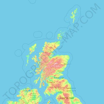
Name: Scotland topographic map, elevation, terrain.
Location: Scotland, United Kingdom (54.43398 -14.01552 61.06100 -0.32092)
Average elevation: 118 ft
Minimum elevation: 0 ft
Maximum elevation: 4,131 ft
A significant exception to the above are the fossil-bearing beds of Old Red Sandstones found principally along the Moray Firth coast. The Highlands are generally mountainous and the highest elevations in the British Isles are found here. Scotland has over 790 islands divided into four main groups: Shetland, Orkney, and the Inner Hebrides and Outer Hebrides. There are numerous bodies of freshwater including Loch Lomond and Loch Ness. Some parts of the coastline consist of machair, a low-lying dune pasture land.
Other topographic maps
Click on a map to view its topography, its elevation and its terrain.
One Tree Close
United Kingdom > England > London
One Tree Close, Nunhead, London Borough of Southwark, London, Greater London, England, SE23 3QZ, United Kingdom
Average elevation: 141 ft
Scottish Highlands
United Kingdom > Scotland > Highland
Scottish Highlands, Highland, Scotland, United Kingdom
Average elevation: 2,976 ft
Coventry
Coventry, West Midlands Combined Authority, England, United Kingdom
Average elevation: 325 ft
Rayleigh
United Kingdom > England > Essex
Rayleigh, Rochford, Essex, England, United Kingdom
Average elevation: 121 ft
City of London
United Kingdom > England > City of London > City of London
City of London, England, EC2V 5AE, United Kingdom
Average elevation: 138 ft
Broxtowe
United Kingdom > England > Nottinghamshire
Broxtowe, Nottinghamshire, England, United Kingdom
Average elevation: 249 ft
Stonehenge
United Kingdom > England > Larkhill
Stonehenge, The Avenue, Amesbury, Larkhill, Wiltshire, South West England, England, SP3 4DX, United Kingdom
Average elevation: 325 ft
Rotherham
Rotherham, South Yorkshire Mayoral Combined Authority, England, United Kingdom
Average elevation: 331 ft
Sunderland
Sunderland, North East, England, United Kingdom
Average elevation: 151 ft
Northampton
United Kingdom > England > West Northamptonshire > Northampton
Northampton, West Northamptonshire, England, United Kingdom
Average elevation: 292 ft
Broadstairs
United Kingdom > England > Kent > Thanet
Broadstairs, Thanet, Kent, England, CT10 1LH, United Kingdom
Average elevation: 46 ft
County Durham
County Durham, North East, England, United Kingdom
Average elevation: 640 ft
Coseley
Coseley, Dudley, West Midlands Combined Authority, England, WV14 9NJ, United Kingdom
Average elevation: 509 ft
Tetbury
United Kingdom > England > Gloucestershire > Cotswold District
Tetbury, Cotswold District, Gloucestershire, England, United Kingdom
Average elevation: 400 ft
Water
United Kingdom > England > Devon > Teignbridge
Water, Teignbridge, Devon, England, TQ13 9UE, United Kingdom
Average elevation: 856 ft
Llanboidy
United Kingdom > Wales > Carmarthenshire
Llanboidy, Carmarthenshire, Wales, SA34 0EL, United Kingdom
Average elevation: 449 ft
Old Brampton
United Kingdom > England > Derbyshire > North East Derbyshire
Old Brampton, North East Derbyshire, Derbyshire, England, S42 7JG, United Kingdom
Average elevation: 594 ft
Codsall
United Kingdom > England > Staffordshire > South Staffordshire
Codsall, South Staffordshire, Staffordshire, England, United Kingdom
Average elevation: 407 ft
Elsdon
United Kingdom > England > Northumberland
Elsdon, Northumberland, North of Tyne, England, United Kingdom
Average elevation: 807 ft
Hanham
United Kingdom > England > South Gloucestershire
Hanham, South Gloucestershire, West of England, England, United Kingdom
Average elevation: 233 ft
Landican
United Kingdom > England > Thingwall
Landican, Thingwall, Wirral, Liverpool City Region, England, CH49 5LJ, United Kingdom
Average elevation: 148 ft
Shrewsbury
United Kingdom > England > Shrewsbury
Shrewsbury, Shropshire, West Midlands, England, SY1 1SF, United Kingdom
Average elevation: 233 ft
Royal Leamington Spa
United Kingdom > England > Royal Leamington Spa
Royal Leamington Spa, Warwickshire, West Midlands, England, CV32 4DB, United Kingdom
Average elevation: 223 ft
Allesley
United Kingdom > England > Coventry
Allesley, Coventry, West Midlands Combined Authority, England, CV5 9GS, United Kingdom
Average elevation: 377 ft
Woolavington
United Kingdom > England > Somerset
Woolavington, Somerset, England, United Kingdom
Average elevation: 56 ft
Alveley
United Kingdom > England > Shropshire
Alveley, Shropshire, England, WV15 6PQ, United Kingdom
Average elevation: 335 ft
Offham
United Kingdom > England > Kent > Tonbridge and Malling
Offham, Tonbridge and Malling, Kent, England, United Kingdom
Average elevation: 315 ft
Cruwys Morchard
United Kingdom > England > Devon > Mid Devon
Cruwys Morchard, Mid Devon, Devon, England, United Kingdom
Average elevation: 636 ft
London
London, Greater London, England, United Kingdom
Average elevation: 217 ft
Goring-on-Thames
United Kingdom > England > Oxfordshire > South Oxfordshire
Goring-on-Thames, South Oxfordshire, Oxfordshire, England, RG8 0EB, United Kingdom
Average elevation: 276 ft
White Cliffs of Dover
United Kingdom > England > Kent > Dover > St. Margaret's at Cliffe
White Cliffs of Dover, St. Margaret's at Cliffe, Dover, Kent, England, United Kingdom
Average elevation: 161 ft
Carlisle
United Kingdom > England > Cumberland
Carlisle, Cumberland, England, United Kingdom
Average elevation: 102 ft
Betws Garmon
United Kingdom > Wales > Gwynedd
Betws Garmon, Gwynedd, Wales, United Kingdom
Average elevation: 935 ft
Welford
United Kingdom > England > West Berkshire
Welford, West Berkshire, England, United Kingdom
Average elevation: 407 ft
Olveston
United Kingdom > England > South Gloucestershire
Olveston, South Gloucestershire, West of England, England, United Kingdom
Average elevation: 102 ft
Whitby
United Kingdom > England > Whitby
Whitby, North Yorkshire, Yorkshire and the Humber, England, YO21 3QF, United Kingdom
Average elevation: 128 ft
Fenny Bentley CP
United Kingdom > England > Derbyshire > Derbyshire Dales
Fenny Bentley CP, Derbyshire Dales, Derbyshire, England, United Kingdom
Average elevation: 633 ft
Kingsley Holt
United Kingdom > England > Staffordshire > Staffordshire Moorlands
Kingsley Holt, Staffordshire Moorlands, Staffordshire, England, ST10 2BG, United Kingdom
Average elevation: 604 ft
Derbyshire Dales
United Kingdom > England > Derbyshire
Derbyshire Dales, Derbyshire, England, United Kingdom
Average elevation: 650 ft
Alfreton Park
United Kingdom > England > Derbyshire > Amber Valley > Alfreton CP > Oakerthorpe
Alfreton Park, Alfreton CP, Oakerthorpe, Amber Valley, Derbyshire, England, DE55 7AL, United Kingdom
Average elevation: 381 ft
Alvescot
United Kingdom > England > Oxfordshire > West Oxfordshire
Alvescot, West Oxfordshire, Oxfordshire, England, United Kingdom
Average elevation: 285 ft
Elveden
United Kingdom > England > Suffolk > West Suffolk
Elveden, West Suffolk, Suffolk, England, United Kingdom
Average elevation: 141 ft
Dalbury
United Kingdom > England > Derbyshire > South Derbyshire
Dalbury, Dalbury Lees CP, South Derbyshire, Derbyshire, England, DE6 5BR, United Kingdom
Average elevation: 249 ft
Cambourne
United Kingdom > England > Cambridgeshire > South Cambridgeshire
Cambourne, South Cambridgeshire, Cambridgeshire, Cambridgeshire and Peterborough, England, United Kingdom
Average elevation: 207 ft
Goblin Ledge
United Kingdom > England > South Gloucestershire > Severn Beach > New Passage
Goblin Ledge, Prince of Wales Bridge, New Passage, Pilning and Severn Beach, Severn Beach, South Gloucestershire, West of England, England, BS35 4NQ, United Kingdom
Average elevation: 7 ft
Hadfield
United Kingdom > England > Derbyshire > High Peak
Hadfield, High Peak, Derbyshire, England, United Kingdom
Average elevation: 571 ft
Hazelwood CP
United Kingdom > England > Derbyshire > Amber Valley
Hazelwood CP, Amber Valley, Derbyshire, England, United Kingdom
Average elevation: 361 ft