
Make a donation
Gear up for your next adventure:
As an Amazon Associate, this site earns from qualifying purchases at no extra cost to you.
West Grove topographic map
Click on the map to display elevation.
Make a donation
Gear up for your next adventure:
As an Amazon Associate, this site earns from qualifying purchases at no extra cost to you.
About this map
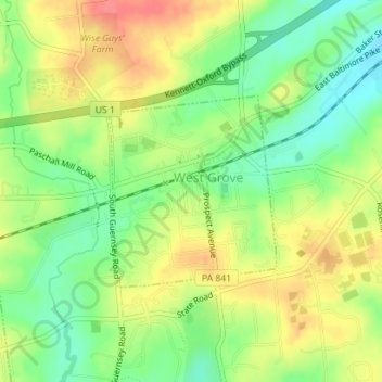
Name: West Grove topographic map, elevation, terrain.
Location: West Grove, Chester County, Pennsylvania, United States (39.81394 -75.83605 39.82747 -75.82048)
Average elevation: 420 ft
Minimum elevation: 315 ft
Maximum elevation: 535 ft
Chester County trails, hiking, mountain biking, running and outdoor activities
Make a donation
Gear up for your next adventure:
As an Amazon Associate, this site earns from qualifying purchases at no extra cost to you.
Other topographic maps
Click on a map to view its topography, its elevation and its terrain.
Exton
United States > Pennsylvania > Chester County > West Whiteland Township
Average elevation: 410 ft
Chesterbrook
United States > Pennsylvania > Chester County > Tredyffrin Township
Average elevation: 266 ft
Daylesford
United States > Pennsylvania > Chester County > Easttown Township
Average elevation: 449 ft
Make a donation
Gear up for your next adventure:
As an Amazon Associate, this site earns from qualifying purchases at no extra cost to you.
West Goshen
United States > Pennsylvania > Chester County > West Goshen Township
Average elevation: 417 ft
Chatwood
United States > Pennsylvania > Chester County > West Goshen Township
Average elevation: 423 ft
Chester Springs
United States > Pennsylvania > Chester County > West Pikeland Township
Average elevation: 367 ft
Make a donation
Gear up for your next adventure:
As an Amazon Associate, this site earns from qualifying purchases at no extra cost to you.
Kimberton
United States > Pennsylvania > Chester County > East Pikeland Township
Kimberton is located at 40°07′50″N 75°34′20″W / 40.13056°N 75.57222°W / 40.13056; -75.57222 (40.130N, -75.572W). The elevation is 207 feet.
Average elevation: 246 ft
Kirkwood Preserve
United States > Pennsylvania > Chester County > Willistown Township
Average elevation: 384 ft
West Pikeland
United States > Pennsylvania > Chester County > West Pikeland Township
Average elevation: 400 ft
Strickersville
United States > Pennsylvania > Chester County > London Britain Township
Average elevation: 308 ft
Make a donation
Gear up for your next adventure:
As an Amazon Associate, this site earns from qualifying purchases at no extra cost to you.
Romansville
United States > Pennsylvania > Chester County > West Bradford Township
Average elevation: 404 ft
Doe Run
United States > Pennsylvania > Chester County > West Marlborough Township
Average elevation: 387 ft
Wilson Farm Park
United States > Pennsylvania > Chester County > Tredyffrin Township > Chesterbrook
Average elevation: 223 ft
Glenloch
United States > Pennsylvania > Chester County > West Whiteland Township
Average elevation: 456 ft
Make a donation
Gear up for your next adventure:
As an Amazon Associate, this site earns from qualifying purchases at no extra cost to you.
Morstein
United States > Pennsylvania > Chester County > West Whiteland Township
Average elevation: 495 ft
Cochranville
United States > Pennsylvania > Chester County > West Fallowfield Township
Average elevation: 558 ft
Make a donation
Gear up for your next adventure:
As an Amazon Associate, this site earns from qualifying purchases at no extra cost to you.
Kenilworth
United States > Pennsylvania > Chester County > North Coventry Township
Average elevation: 200 ft
Make a donation
Gear up for your next adventure:
As an Amazon Associate, this site earns from qualifying purchases at no extra cost to you.
Pughtown
United States > Pennsylvania > Chester County > South Coventry Township
Average elevation: 400 ft
South Pottstown
United States > Pennsylvania > Chester County > North Coventry Township
Average elevation: 200 ft
Make a donation
Gear up for your next adventure:
As an Amazon Associate, this site earns from qualifying purchases at no extra cost to you.
Toughkenamon
United States > Pennsylvania > Chester County > New Garden Township
Average elevation: 377 ft
Unionville
United States > Pennsylvania > Chester County > East Marlborough Township
Average elevation: 440 ft
Black Horse
United States > Pennsylvania > Chester County > West Sadsbury Township
Average elevation: 692 ft
Make a donation
Gear up for your next adventure:
As an Amazon Associate, this site earns from qualifying purchases at no extra cost to you.
Brandamore
United States > Pennsylvania > Chester County > West Brandywine Township
Average elevation: 627 ft
Cedarville
United States > Pennsylvania > Chester County > North Coventry Township
Average elevation: 269 ft
Chatham
United States > Pennsylvania > Chester County > London Grove Township
Average elevation: 436 ft
Chesterville
United States > Pennsylvania > Chester County > Franklin Township
Average elevation: 338 ft
Make a donation
Gear up for your next adventure:
As an Amazon Associate, this site earns from qualifying purchases at no extra cost to you.
Coventryville
United States > Pennsylvania > Chester County > South Coventry Township
Average elevation: 449 ft
Darlington Corners
United States > Pennsylvania > Chester County > Thornbury Township > Westtown
Average elevation: 364 ft
Make a donation
Gear up for your next adventure:
As an Amazon Associate, this site earns from qualifying purchases at no extra cost to you.
Dorlan
United States > Pennsylvania > Chester County > East Brandywine Township
Average elevation: 433 ft
Ercildoun
United States > Pennsylvania > Chester County > East Fallowfield Township
Average elevation: 489 ft
Faggs Manor
United States > Pennsylvania > Chester County > Londonderry Township
Average elevation: 581 ft
Goshenville
United States > Pennsylvania > Chester County > East Goshen Township
Average elevation: 433 ft
Make a donation
Gear up for your next adventure:
As an Amazon Associate, this site earns from qualifying purchases at no extra cost to you.
Hallman
United States > Pennsylvania > Chester County > East Pikeland Township
Average elevation: 308 ft
Harmonyville
United States > Pennsylvania > Chester County > Warwick Township
Average elevation: 574 ft
Hayesville
United States > Pennsylvania > Chester County > Lower Oxford Township
Average elevation: 535 ft
Hephzibah
United States > Pennsylvania > Chester County > East Fallowfield Township
Average elevation: 433 ft
Make a donation
Gear up for your next adventure:
As an Amazon Associate, this site earns from qualifying purchases at no extra cost to you.
Hiestand
United States > Pennsylvania > Chester County > East Vincent Township
Average elevation: 292 ft
Homeville
United States > Pennsylvania > Chester County > Upper Oxford Township
Average elevation: 453 ft
Hopewell
United States > Pennsylvania > Chester County > East Nottingham Township
Average elevation: 446 ft
Humphreyville
United States > Pennsylvania > Chester County > East Fallowfield Township
Average elevation: 551 ft
Make a donation
Gear up for your next adventure:
As an Amazon Associate, this site earns from qualifying purchases at no extra cost to you.
Icedale
United States > Pennsylvania > Chester County > West Brandywine Township
Average elevation: 650 ft
Ironsides
United States > Pennsylvania > Chester County > Schuylkill Township
Ironsides is a populated place located within the township of Schuylkill in Chester County, Pennsylvania, United States. It has an estimated elevation of 118 feet (36 m) above sea level.
Average elevation: 200 ft
Isabella
United States > Pennsylvania > Chester County > West Nantmeal Township
Average elevation: 656 ft
Make a donation
Gear up for your next adventure:
As an Amazon Associate, this site earns from qualifying purchases at no extra cost to you.
Kemblesville
United States > Pennsylvania > Chester County > Franklin Township
Average elevation: 341 ft
Make a donation
Gear up for your next adventure:
As an Amazon Associate, this site earns from qualifying purchases at no extra cost to you.
Lenape
United States > Pennsylvania > Chester County > Pocopson Township > Pocopson
Average elevation: 259 ft
London Grove
United States > Pennsylvania > Chester County > West Marlborough Township
Average elevation: 430 ft
Lower Hopewell
United States > Pennsylvania > Chester County > Lower Oxford Township
Average elevation: 420 ft
Make a donation
Gear up for your next adventure:
As an Amazon Associate, this site earns from qualifying purchases at no extra cost to you.
Ludwigs Corner
United States > Pennsylvania > Chester County > West Vincent Township
Average elevation: 597 ft
Lyndell
United States > Pennsylvania > Chester County > East Brandywine Township
Average elevation: 449 ft
Mortonville
United States > Pennsylvania > Chester County > East Fallowfield Township
Average elevation: 400 ft
Make a donation
Gear up for your next adventure:
As an Amazon Associate, this site earns from qualifying purchases at no extra cost to you.
Nantmeal Village
United States > Pennsylvania > Chester County > East Nantmeal Township
Average elevation: 561 ft
Parker Ford
United States > Pennsylvania > Chester County > East Coventry Township
Average elevation: 197 ft
Russellville
United States > Pennsylvania > Chester County > Upper Oxford Township
Average elevation: 577 ft
Saint Peters
United States > Pennsylvania > Chester County > Warwick Township
Average elevation: 515 ft
Make a donation
Gear up for your next adventure:
As an Amazon Associate, this site earns from qualifying purchases at no extra cost to you.
Siousca
United States > Pennsylvania > Chester County > West Brandywine Township
Average elevation: 509 ft
Springdell
United States > Pennsylvania > Chester County > West Marlborough Township
Average elevation: 433 ft
Steelville
United States > Pennsylvania > Chester County > West Fallowfield Township
Average elevation: 538 ft
Sugartown
United States > Pennsylvania > Chester County > Willistown Township
Average elevation: 449 ft
Make a donation
Gear up for your next adventure:
As an Amazon Associate, this site earns from qualifying purchases at no extra cost to you.
Whitford
United States > Pennsylvania > Chester County > West Whiteland Township
Average elevation: 400 ft
Willowdale
United States > Pennsylvania > Chester County > East Marlborough Township
Average elevation: 394 ft
Make a donation
Gear up for your next adventure:
As an Amazon Associate, this site earns from qualifying purchases at no extra cost to you.
flood plane
United States > Pennsylvania > Chester County > Uwchlan Township > Lionville
Average elevation: 489 ft
Pottstown Landing
United States > Pennsylvania > Chester County > North Coventry Township
Average elevation: 217 ft
Whiteland Crest
United States > Pennsylvania > Chester County > West Whiteland Township > Exton
Average elevation: 417 ft
Whitehorse
United States > Pennsylvania > Chester County > Willistown Township
Average elevation: 384 ft
Make a donation
Gear up for your next adventure:
As an Amazon Associate, this site earns from qualifying purchases at no extra cost to you.
Milford Mills
United States > Pennsylvania > Chester County > Upper Uwchlan Township
Average elevation: 413 ft
Marshallton
United States > Pennsylvania > Chester County > West Bradford Township
Average elevation: 322 ft
Make a donation
Gear up for your next adventure:
As an Amazon Associate, this site earns from qualifying purchases at no extra cost to you.
Grove
United States > Pennsylvania > Chester County > West Whiteland Township > Grove
Average elevation: 420 ft
Gallagherville
United States > Pennsylvania > Chester County > Gallagherville
Average elevation: 377 ft
Slonaker
United States > Pennsylvania > Chester County > East Vincent Township > Slonaker
Average elevation: 322 ft
Make a donation
Gear up for your next adventure:
As an Amazon Associate, this site earns from qualifying purchases at no extra cost to you.
Sadsburyville
United States > Pennsylvania > Chester County > Sadsbury Township
Average elevation: 627 ft
Hershey Mill
United States > Pennsylvania > Chester County > East Goshen Township > Hershey Mill
Average elevation: 492 ft
Bucktown
United States > Pennsylvania > Chester County > South Coventry Township
Average elevation: 377 ft
Eagle
United States > Pennsylvania > Chester County > Upper Uwchlan Township
Average elevation: 476 ft
Make a donation
Gear up for your next adventure:
As an Amazon Associate, this site earns from qualifying purchases at no extra cost to you.
Charlestown
United States > Pennsylvania > Chester County > Charlestown Township > Charlestown
Average elevation: 331 ft
Birchrunville
United States > Pennsylvania > Chester County > West Vincent Township
Average elevation: 463 ft