
Maroochydore topographic map
Click on the map to display elevation.
About this map
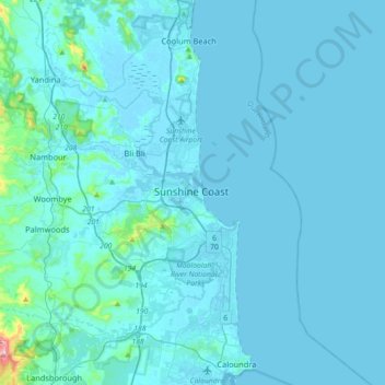
Name: Maroochydore topographic map, elevation, terrain.
Location: Maroochydore, Queensland, 4572, Australia (-26.69565 153.05467 -26.61565 153.13467)
Average elevation: 43 ft
Minimum elevation: -7 ft
Maximum elevation: 505 ft
Other topographic maps
Click on a map to view its topography, its elevation and its terrain.
City of Brisbane
Brisbane's topography is characterized by a series of hills and ranges that define its landscape. The city is situated on a low-lying floodplain, with the Brisbane River meandering through its heart, creating a winding course with many steep curves from the southwest to its mouth at Moreton Bay in the east.…
Average elevation: 233 ft
Herbert River
With its headwaters forming at an elevation of 1,070 metres (3,510 ft) on the Atherton Tableland, part of the Great Dividing Range west of Herberton and north of Ravenshoe, the Herbert River is formed by the confluence of the Millstream and the Wild River. The Herbert River flows in a generally southeastern…
Average elevation: 1,503 ft
Warwick
Warwick experiences an altitude-influenced humid subtropical climate (Köppen: Cfa), with hot summers and mild, relatively dry winters with cold nights. Annual precipitation averages 662.4 millimetres (26.08 in), with a summer maximum. The town is slightly cooler and less humid than the proximate southeast…
Average elevation: 1,555 ft
Brisbane River
The RAAF also perform a practice session in the days preceding the event, serving as an opportunity to both practice beforehand and also promote Riverfire. One of the most popular RAAF aircraft to perform at Riverfire was the F-111 which was known for performing a 'dump-and-burn' above the city. The final…
Average elevation: 771 ft
Nundah
Schulz Canal runs through Nundah, bisecting the Toombul Shopping Centre Carpark. The low elevation of the carpark makes it particularly susceptible to flash flooding during peak storm seasons – often claiming the cars of unwary shoppers inside the centre and those attempting to cross the Melton Road bridge.…
Average elevation: 46 ft
Sunshine Coast Regional
The Sunshine Coast Regional area in Queensland, Australia, features a diverse topography that ranges from coastal plains to rugged hinterlands. Along the coastline, the terrain is predominantly flat, with average elevations around 20 meters (66 feet) above sea level. Inland, the landscape transitions to…
Average elevation: 184 ft
Upper Kedron
Australia > Queensland > City of Brisbane
The proposed development responds to the site's topography by offering a range of living options, ranging from bush blocks, to lots designed for terrace-style dwellings.
Average elevation: 348 ft
Whites Hill Reserve
Australia > Queensland > Brisbane City
Whites Hill is named after Robert (Bob) White, who, in 1873, acquired 21.5 hectares (53 acres) of land surrounding the 120 metres (390 ft) elevation now known as Whites Hill. Halfway up the hill facing Coorparoo, the White family built their family home. In 1886, White installed a powerful telescope, which he…
Average elevation: 157 ft