
Isabela topographic map
Click on the map to display elevation.
Isabela
The province is divided into three physiographic areas. The eastern area, straddled by the Sierra Madre mountain range, is rugged and thickly forested. A substantial portion is uncharted. These unexplored hinterlands are home to a rich variety of flora and fauna, and some are under government reservations. It is home to one of the world's largest remaining low-altitude rainforests, with numerous unknown endemic species of flora and fauna and biological diversity in the protected area known as the Northern Sierra Madre Natural Park. Isabela has 600,000 hectares (1,500,000 acres) of Cagayan Valley’s 900,000 hectares (2,200,000 acres) of forest cover.
About this map
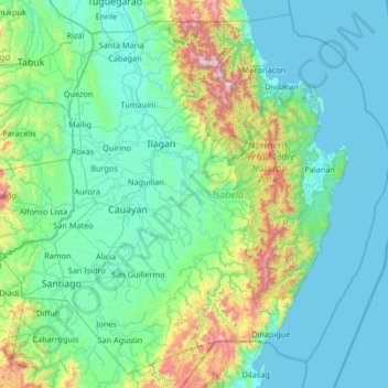
Name: Isabela topographic map, elevation, terrain.
Location: Isabela, Cagayan Valley, Philippines (16.39443 121.33589 17.56891 122.66939)
Average elevation: 745 ft
Minimum elevation: -3 ft
Maximum elevation: 5,892 ft
Other topographic maps
Click on a map to view its topography, its elevation and its terrain.
Quezon City
Founded as a pueblo by Saint Pedro Bautista in 1590, San Francisco del Monte may be considered Quezon City's oldest district. The original land area of the old town of San Francisco del Monte was approximately2.5 square kilometres (1.0 sq mi) and covered parts of what is currently known as Project 7 and 8 and…
Average elevation: 187 ft
Malolos
Malolos is relatively flat of about 0.81% to a gently sloping of 2.17%. The slope of the land descends towards west, southwest to southern direction. The highest land elevation is at about 6.0 meters above sea level while the lowest is only half a meter below sea level. A network of natural waterways and…
Average elevation: 20 ft
Lake Sebu
The placid lake of Lake Sebu can be found in Allah Valley near the municipality of Surallah, South Cotabato. Surrounded by rolling hills and mountains covered with thick rain forest, the lake has an area of 361.124 hectares (892.36 acres), with an elevation of approximately 1,000 metres (3,300 ft).
Average elevation: 2,461 ft
San Juan
"San Juan" is a contraction of the city's traditional name of "San Juan del Monte" (lit. 'Saint John of the Mountain'). As with numerous other places in the Philippines, the name combines a patron saint and a toponym; in this case Saint John the Baptist with the locale's hilly terrain and relatively higher…
Average elevation: 115 ft
Calanasan
The town's topography or slope is predominantly rugged and mountainous with sporadic flood plains and plateaus. The municipality cradles the larger part of the Apayao-Abulog watershed area as the main source of streams that fills the mighty river which originates from the municipality.
Average elevation: 1,719 ft
San Jose
The city of San Jose lies at 15° 47' North, 120° 59' East in Central Luzon. The estimated elevation at these coordinates is approximately 109.9 meters or 360.4 feet above mean sea level.
Average elevation: 574 ft
Bacolod
Bacólod (English: Bacolod), is derived from bakólod (Old Spelling: bacólod), the Old Hiligaynon (Old Ilonggo) (Old Spelling: Ylongo and Ilongo) word for a "hill, turtle, mound, rise, hillock, down, any small eminence or elevation", since the resettlement was founded on a stony, hilly area, now the barangay…
Average elevation: 161 ft
Valenzuela
The highest elevation point is 38 meters (125 ft) above sea level. Having a surface gradient of 0.55% and a gentle slope, hilly landscape is located in the industrial section of the city in Canumay. The average elevation point is 2 meters (6.6 ft) above sea level.
Average elevation: 79 ft
Vigan
Vigan is situated in a Quaternary Age sedimentary plain called the Vigan-Bantay Plain which is part of the Ilocos coastal plain. The Vigan-Bantay Plain is bounded on the east by a moderately rugged Miocene sediments consisting of interbedded sandstones and shale to very rugged Meta-volcanics and Meta sediment…
Average elevation: 207 ft
Baguio
In 1903, Filipinos, Japanese and Chinese workers were hired to build Kennon Road, the first road directly connecting Baguio with the lowlands of La Union and Pangasinan. Before this, the only road to Benguet was Naguilian Road, and it was largely a horse trail at higher elevations. Camp John Hay was…
Average elevation: 2,890 ft
San Gabriel
The Municipality of San Gabriel is recognized as the largest municipality by land area in La Union. The town’s topography is predominantly mountainous, gradually ascending eastward, with a mix of scrubland, grassland, and wetland ecosystems. Its landscape is traversed by the Baroro River, the town's major…
Average elevation: 430 ft
Legazpi
Legazpi's topography is generally plain on the northeastern areas, with slopes ranging from five to fifteen degrees. The southern areas have mostly rolling to hilly terrain. In the city's coastal areas, the terrain varies from plain (north) to hilly (south). Legazpi is criss-crossed by several rivers including…
Average elevation: 492 ft
Mount Banahaw
Philippines > Quezon > Tayabas
The andesitic Banahaw volcanic complex is composed of several stratovolcanoes with Mount Banahaw, the largest with a maximum elevation of 2,170 metres (7,119 ft) above mean sea level. The summit is topped by a 1.5 by 3.5 kilometres (0.93 mi × 2.17 mi) and 210 metres (690 ft) deep crater that is breached on…
Average elevation: 5,676 ft
Valencia
The city's topography is characterized as flat to undulating hills with extensive plateaus and mountainous areas and cliffs on both eastern and western portions bounding the municipality of San Fernando on the east and the municipality of Talakag on the west. Its highest point is Mount Kalatungan in the…
Average elevation: 1,857 ft
Janiuay
Santo Tomas approximate population is 500–800. Santo Tomas (Pakol to locals) is bounded by Madong in the east, Mangil in the north-east and Danao in the south west. It is accessible by three class C feeder roads in the east, south-west and south-east. Agriculture centers around rice, corn, coffee, beans,…
Average elevation: 269 ft
Sipocot
Sipocot spans a total land area of approximately 218.60 square kilometers, making it one of the larger municipalities in Camarines Sur in terms of land size. Its topography is a mix of coastal plains, rolling hills, and forested uplands, with various rivers and streams contributing to the local ecosystem and…
Average elevation: 200 ft
Kibungan
The municipality is within a cool highland mountainous zone with elevations at more than 2,500 metres (8,200 ft) above sea level. During its coolest months of December to January, Barangay Madaymen experiences chilling temperature of 0 °C (32 °F), causing the famous Frost of Madaymen.
Average elevation: 4,075 ft
Mandaue
It is one of the two (the other one being the municipality of Consolacion) local government units located within the mainland Metro Cebu where the elevation of land is less than 100 m (330 ft).
Average elevation: 358 ft
Trece Martires
The city of Trece Martires is characterised with ground elevation ranging from 30m to nearly 400m. Its ground slope ranges from 0.5 to 2%.
Average elevation: 492 ft
Mandaluyong
Another claims that the Spaniards named the place based on the report of a navigator named Acapulco, who saw the rolling hills frequently being lashed at by daluyong (“big waves from the sea”). This seems to confirm traditional pre-Hispanic stories that giant waves from the sea would meet the adjoining…
Average elevation: 108 ft
San Juan
"San Juan" is a contraction of the city's traditional name of "San Juan del Monte" (lit. 'Saint John of the Mountain'). As with numerous other places in the Philippines, the name combines a patron saint and a toponym; in this case Saint John the Baptist with the locale's hilly terrain and relatively higher…
Average elevation: 115 ft