
Hegarmanah topographic map
Interactive map
Click on the map to display elevation.
About this map
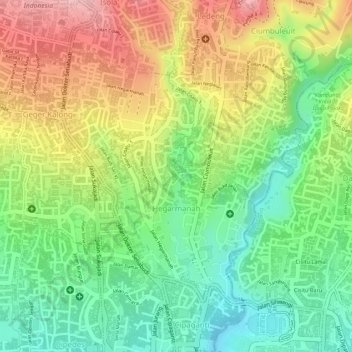
Name: Hegarmanah topographic map, elevation, terrain.
Location: Hegarmanah, Cidadap, Bandung, West Java, 40141, Indonesia (-6.88467 107.59346 -6.86510 107.60847)
Average elevation: 2,717 ft
Minimum elevation: 2,448 ft
Maximum elevation: 3,025 ft
Other topographic maps
Click on a map to view its topography, its elevation and its terrain.
Sukamiskin
Indonesia > West Java > Bandung
Sukamiskin, Arcamanik, Bandung, West Java, Java, 40293, Indonesia
Average elevation: 2,251 ft
Cihaurgeulis
Indonesia > West Java > Bandung
Cihaurgeulis, Cibeunying Kaler, Bandung, West Java, Java, Indonesia
Average elevation: 2,349 ft
Babakan Asih
Indonesia > West Java > Bandung
Babakan Asih, Bojongloa Kaler, Bandung, West Java, Java, 40232, Indonesia
Average elevation: 2,300 ft
Babakan Penghulu
Indonesia > West Java > Bandung
Babakan Penghulu, Cinambo, Bandung, West Java, Java, Indonesia
Average elevation: 2,205 ft
Nyengseret
Indonesia > West Java > Bandung
Nyengseret, Astanaanyar, Bandung, West Java, Java, Indonesia
Average elevation: 2,293 ft
Rancabolang
Indonesia > West Java > Bandung
Rancabolang, Gedebage, Bandung, West Java, Java, Indonesia
Average elevation: 2,178 ft
Cimincrang
Indonesia > West Java > Bandung
Cimincrang, Gedebage, Bandung, West Java, Java, Indonesia
Average elevation: 2,188 ft
Sadang Serang
Indonesia > West Java > Bandung
Sadang Serang, Coblong, Bandung, West Java, Java, 40133, Indonesia
Average elevation: 2,441 ft
Sungai penuh sampah
Indonesia > West Java > Bandung > Situ Saeur
Sungai penuh sampah, Situ Saeur, Bojongloa Kidul, Bandung, West Java, 40236, Indonesia
Average elevation: 2,257 ft
Lingkar Selatan
Indonesia > West Java > Bandung
Lingkar Selatan, Lengkong, Bandung, West Java, Indonesia
Average elevation: 2,267 ft
Kebon Pisang
Indonesia > West Java > Bandung
Kebon Pisang, Sumur Bandung, Bandung, West Java, 40112, Indonesia
Average elevation: 2,313 ft
Ciumbuleuit
Indonesia > West Java > Bandung
Ciumbuleuit, Cidadap, Bandung, West Java, 40142, Indonesia
Average elevation: 2,946 ft
Husen Sastranegara
Indonesia > West Java > Bandung > Husen Sastranegara
Husen Sastranegara, Cicendo, Bandung, West Java, Indonesia
Average elevation: 2,428 ft
Cisaranten Kidul
Indonesia > West Java > Bandung
Cisaranten Kidul, Gedebage, Bandung, West Java, Java, Indonesia
Average elevation: 2,188 ft
Mekarwangi
Indonesia > West Java > Bandung > Mekarwangi
Mekarwangi, Bojongloa Kidul, Bandung, West Java, Indonesia
Average elevation: 2,224 ft
Sungai Ci Kapundung
Indonesia > West Java > Bandung
Sungai Ci Kapundung, Bandung, West Java, 40288, Indonesia
Average elevation: 2,175 ft