
Nantucket topographic map
Click on the map to display elevation.
About this map
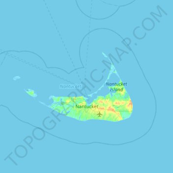
Name: Nantucket topographic map, elevation, terrain.
Location: Nantucket, Massachusetts, United States (41.18886 -70.39736 41.44339 -69.89364)
Average elevation: 3 ft
Minimum elevation: -20 ft
Maximum elevation: 92 ft
Massachusetts trails, hiking, mountain biking, running and outdoor activities
Other topographic maps
Click on a map to view its topography, its elevation and its terrain.
Boston
United States > Massachusetts > Suffolk County > Boston
Boston has an area of 89.63 sq mi (232.1 km2)—48.4 sq mi (125.4 km2) (54%) of land and41.2 sq mi (106.7 km2) (46%) of water. The city's official elevation, as measured at Logan International Airport, is 19 ft (5.8 m) above sea level. The highest point in Boston is Bellevue Hill at 330 ft (100 m) above sea…
Average elevation: 85 ft
Mittineague
United States > Massachusetts > Hampden County > West Springfield
Average elevation: 161 ft
Leonard and Marydee Flynn Cons Area
United States > Massachusetts > Bristol County > Mansfield
Average elevation: 128 ft
West Meadow
United States > Massachusetts > Plymouth County > West Bridgewater
Average elevation: 95 ft
Mount Everett
United States > Massachusetts > Berkshire County
Mount Everett helps divide the watersheds of the Hudson and Housatonic rivers. Its eastern slopes share a larger escarpment with Mount Race and Bear Mountain plus several related summits. This escarpment rises from an elevation around 700 feet in Sheffield's Housatonic Valley at a mean angle of about 20…
Average elevation: 1,841 ft
Opeechee Heights Beach
United States > Massachusetts > Barnstable County > Barnstable > Centerville
Average elevation: 46 ft
Hephzibah Heights
United States > Massachusetts > Berkshire County > Monterey
Average elevation: 1,499 ft
Charles River Village
United States > Massachusetts > Norfolk County > Needham
Average elevation: 161 ft
Duckville
United States > Massachusetts > Hampden County > Palmer > Bondsville
Average elevation: 440 ft
Mount Greylock
United States > Massachusetts > Berkshire County > Adams
Geographically, Mount Greylock is part of an 11-mile-long (18 km) by 4+1⁄2-mile-wide (7 km) island-like range that runs north-south between the Hoosac Range to the east, the Green Mountains to the north, the Berkshires to both the south and east, and the Taconic Mountains to the west with which it is…
Average elevation: 2,448 ft
North Tewksbury
United States > Massachusetts > Middlesex County > Tewksbury
Average elevation: 157 ft
Framingham Center
United States > Massachusetts > Middlesex County > Framingham
Average elevation: 190 ft
Gates Crossing
United States > Massachusetts > Worcester County > Leominster
Average elevation: 407 ft
Southfield
United States > Massachusetts > Berkshire County > New Marlborough
Average elevation: 1,329 ft
Wachusett Station
United States > Massachusetts > Worcester County > Fitchburg
Average elevation: 751 ft