
Make a donation
Gear up for your next adventure:
As an Amazon Associate, this site earns from qualifying purchases at no extra cost to you.
Mora topographic map
Click on the map to display elevation.
Make a donation
Gear up for your next adventure:
As an Amazon Associate, this site earns from qualifying purchases at no extra cost to you.
About this map
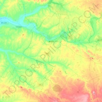
Name: Mora topographic map, elevation, terrain.
Location: Mora, Évora, Portugal (38.80497 -8.27219 39.02693 -7.88979)
Average elevation: 423 ft
Minimum elevation: 75 ft
Maximum elevation: 1,014 ft
Make a donation
Gear up for your next adventure:
As an Amazon Associate, this site earns from qualifying purchases at no extra cost to you.
Other topographic maps
Click on a map to view its topography, its elevation and its terrain.
Moinho de Vento
Portugal > Évora > Évora > Nossa Senhora da Graça do Divor
Average elevation: 1,070 ft
Make a donation
Gear up for your next adventure:
As an Amazon Associate, this site earns from qualifying purchases at no extra cost to you.
Make a donation
Gear up for your next adventure:
As an Amazon Associate, this site earns from qualifying purchases at no extra cost to you.
Make a donation
Gear up for your next adventure:
As an Amazon Associate, this site earns from qualifying purchases at no extra cost to you.
Make a donation
Gear up for your next adventure:
As an Amazon Associate, this site earns from qualifying purchases at no extra cost to you.
Make a donation
Gear up for your next adventure:
As an Amazon Associate, this site earns from qualifying purchases at no extra cost to you.
Aqueduto da Água de Prata
A paisagem que acompanha o aqueduto entre as Muralhas Fernandinas de Évora e as nascentes, num vale próximo da Igreja Paroquial de Nossa Senhora da Graça do Divor (Graça do Divor, Évora), nos campos do Convento São Bento de Castris, apresenta uma diversidade que passa por grandes áreas de pastagens e…
Average elevation: 1,030 ft
Make a donation
Gear up for your next adventure:
As an Amazon Associate, this site earns from qualifying purchases at no extra cost to you.
Alandroal
Portugal > Évora > Alandroal (Nossa Senhora da Conceição), São Brás dos Matos (Mina do Bugalho) e Juromenha (Nossa Senhora do Loreto)
Erguendo-se a 341 m de altitude, Alandroal foi elevada à categoria de vila em 1486 por Carta de Foral concedida pelo rei D. João II.
Average elevation: 1,004 ft
Make a donation
Gear up for your next adventure:
As an Amazon Associate, this site earns from qualifying purchases at no extra cost to you.
São Bartolomeu do Outeiro
Portugal > Évora > São Bartolomeu do Outeiro e Oriola
Average elevation: 928 ft
Make a donation
Gear up for your next adventure:
As an Amazon Associate, this site earns from qualifying purchases at no extra cost to you.
Sabugueiro
Portugal > Évora > Gafanhoeira (São Pedro) e Sabugueiro > Sabugueiro
Average elevation: 761 ft
Make a donation
Gear up for your next adventure:
As an Amazon Associate, this site earns from qualifying purchases at no extra cost to you.
Silveiras
Portugal > Évora > Nossa Senhora da Vila, Nossa Senhora do Bispo e Silveiras
Average elevation: 594 ft