
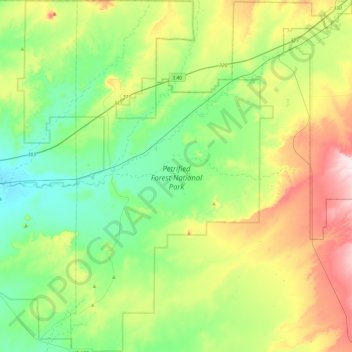
Petrified Forest National Park topographic map
Interactive map
Click on the map to display elevation.
About this map
Name: Petrified Forest National Park topographic map, elevation, terrain.
Average elevation: 5,650 ft
Minimum elevation: 5,220 ft
Maximum elevation: 6,565 ft
Averaging about 5,400 feet (1,600 m) in elevation, the park has a dry windy climate with temperatures that vary from summer highs of about 100 °F (38 °C) to winter lows well below freezing. More than 400 species of plants, dominated by grasses such as bunchgrass, blue grama, and sacaton, are found in the park. Fauna include larger animals such as pronghorns, coyotes, and bobcats, many smaller animals, such as deer mice, snakes, lizards, seven kinds of amphibians, and more than 200 species of birds, some of which are permanent residents and many of which are migratory. About one third of the park is designated wilderness—50,260 acres (79 sq mi; 203 km2).
Other topographic maps
Click on a map to view its topography, its elevation and its terrain.
Fort Defiance
United States > Arizona > Apache County
Fort Defiance, Fort Defiance Agency, Apache County, Arizona, 86504, United States
Average elevation: 7,028 ft
Concho
United States > Arizona > Apache County
Concho, Apache County, Arizona, 85914, United States
Average elevation: 6,050 ft
Nutrioso
United States > Arizona > Apache County
Nutrioso, Apache County, Arizona, 85932, United States
Average elevation: 7,887 ft
Alpine
United States > Arizona > Apache County
Alpine, Apache County, Arizona, 75920, United States
Average elevation: 8,566 ft
McNary
United States > Arizona > Apache County
McNary, Apache County, Arizona, 85930, United States
Average elevation: 7,310 ft
Ganado
United States > Arizona > Apache County
Ganado, Fort Defiance Agency, Apache County, Arizona, United States
Average elevation: 6,532 ft
Dennehotso
United States > Arizona > Apache County
Dennehotso, Apache County, Arizona, 86535, United States
Average elevation: 5,049 ft
Round Rock
United States > Arizona > Apache County
Round Rock, Chinle Agency, Apache County, Arizona, 86547, United States
Average elevation: 5,459 ft
Burnside
United States > Arizona > Apache County
Burnside, Fort Defiance Agency, Apache County, Arizona, United States
Average elevation: 6,417 ft
Tsaile
United States > Arizona > Apache County
Tsaile, Chinle Agency, Apache County, Arizona, United States
Average elevation: 7,080 ft
Houck
United States > Arizona > Apache County
Houck, Fort Defiance Agency, Apache County, Arizona, United States
Average elevation: 6,201 ft
Lukachukai
United States > Arizona > Apache County
Lukachukai, Chinle Agency, Apache County, Arizona, 86507, United States
Average elevation: 6,575 ft
Many Farms
United States > Arizona > Apache County
Many Farms, Chinle Agency, Apache County, Arizona, 86538, United States
Average elevation: 5,331 ft
Rock Point
United States > Arizona > Apache County
Rock Point, Shiprock Agency, Apache County, Arizona, United States
Average elevation: 5,039 ft
Sanders
United States > Arizona > Apache County
Sanders, Apache County, Arizona, 86512, United States
Average elevation: 5,909 ft
Blue Gap
United States > Arizona > Apache County
Blue Gap, Chinle Agency, Apache County, Arizona, 86520, United States
Average elevation: 6,526 ft
Cottonwood
United States > Arizona > Apache County
Cottonwood, Chinle Agency, Apache County, Arizona, United States
Average elevation: 6,145 ft
Cornfields
United States > Arizona > Apache County
Cornfields, Fort Defiance Agency, Apache County, Arizona, United States
Average elevation: 6,168 ft
Del Muerto
United States > Arizona > Apache County
Del Muerto, Chinle Agency, Apache County, Arizona, United States
Average elevation: 6,417 ft
Teec Nos Pos
United States > Arizona > Apache County
Teec Nos Pos, Shiprock Agency, Apache County, Arizona, United States
Average elevation: 5,315 ft
Chinle Agency
United States > Arizona > Apache County
Chinle Agency, Apache County, Arizona, United States
Average elevation: 6,450 ft
Vernon
United States > Arizona > Apache County
Vernon, Apache County, Arizona, 89540, United States
Average elevation: 6,952 ft
Eagar
United States > Arizona > Apache County
Eagar, Apache County, Arizona, 85925, United States
Average elevation: 7,306 ft
Window Rock
United States > Arizona > Apache County
Window Rock, Fort Defiance Agency, Apache County, Arizona, United States
Average elevation: 6,837 ft
Upper Forest Mountain
United States > Arizona > Apache County
Upper Forest Mountain, Chinle Agency, Apache County, Arizona, United States
Average elevation: 7,477 ft
Coyote Springs
United States > Arizona > Apache County
Coyote Springs, Chinle Agency, Apache County, Arizona, United States
Average elevation: 5,719 ft
Chambers
United States > Arizona > Apache County
Chambers, Apache County, Arizona, United States
Average elevation: 5,827 ft
Fort Defiance Agency
United States > Arizona > Apache County
Fort Defiance Agency, Apache County, Arizona, United States
Average elevation: 6,276 ft
Lupton
United States > Arizona > Apache County
Lupton, Fort Defiance Agency, Apache County, Arizona, 86508, United States
Average elevation: 6,371 ft
Window Rock
United States > Arizona > Apache County
Window Rock, Apache County, Arizona, United States
Average elevation: 6,837 ft
Cerro Hueco
United States > Arizona > Apache County
Cerro Hueco, Apache County, Arizona, United States
Average elevation: 6,906 ft
Hawley Lake
United States > Arizona > Apache County > Hawley Lake
Hawley Lake, Apache County, Arizona, United States
Average elevation: 8,327 ft
St. Johns
United States > Arizona > Apache County > St. Johns > St. Johns
St. Johns, Apache County, Arizona, 85936, United States
Average elevation: 5,758 ft
White Hills
United States > Arizona > Apache County
White Hills, Chinle Agency, Apache County, Arizona, United States
Average elevation: 5,909 ft
Greer
United States > Arizona > Apache County
Greer, Apache County, Arizona, 85927, United States
Average elevation: 8,757 ft
White Butte
United States > Arizona > Apache County
White Butte, Chinle Agency, Apache County, Arizona, United States
Average elevation: 7,251 ft
Saint Michaels
United States > Arizona > Apache County
Saint Michaels, Fort Defiance Agency, Apache County, Arizona, 86511, United States
Average elevation: 6,755 ft
Springerville
United States > Arizona > Apache County
Springerville, Apache County, Arizona, United States
Average elevation: 7,054 ft
St. Johns
United States > Arizona > Apache County
St. Johns, Apache County, Arizona, 85936, United States
Average elevation: 5,764 ft
Steamboat
United States > Arizona > Apache County
Steamboat, Fort Defiance Agency, Apache County, Arizona, United States
Average elevation: 6,460 ft
Chinle
United States > Arizona > Apache County
Chinle, Chinle Agency, Apache County, Arizona, United States
Average elevation: 5,627 ft
Red Rock
United States > Arizona > Apache County
Red Rock, Shiprock Agency, Apache County, Arizona, United States
Average elevation: 5,840 ft