
Edinburgh topographic map
Click on the map to display elevation.
Edinburgh
Edinburgh has been popularly called the Athens of the North since the early 19th century. References to Athens, such as Athens of Britain and Modern Athens, had been made as early as the 1760s. The similarities were seen to be topographical but also intellectual. Edinburgh's Castle Rock reminded returning grand tourists of the Athenian Acropolis, as did aspects of the neoclassical architecture and layout of New Town. Both cities had flatter, fertile agricultural land sloping down to a port several miles away (respectively, Leith and Piraeus). Intellectually, the Scottish Enlightenment, with its humanist and rationalist outlook, was influenced by Ancient Greek philosophy. In 1822, artist Hugh William Williams organized an exhibition that showed his paintings of Athens alongside views of Edinburgh, and the idea of a direct parallel between both cities quickly caught the popular imagination. When plans were drawn up in the early 19th century to architecturally develop Calton Hill, the design of the National Monument directly copied Athens' Parthenon. Tom Stoppard's character Archie of Jumpers said, perhaps playing on Reykjavík meaning "smoky bay", that the "Reykjavík of the South" would be more appropriate.
About this map
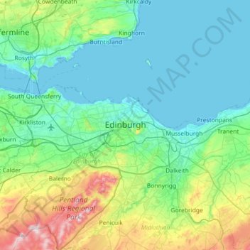
Name: Edinburgh topographic map, elevation, terrain.
Location: Edinburgh, City of Edinburgh, Scotland, United Kingdom (55.79335 -3.34837 56.11335 -3.02837)
Average elevation: 341 ft
Minimum elevation: -10 ft
Maximum elevation: 1,896 ft
Other topographic maps
Click on a map to view its topography, its elevation and its terrain.
Out Skerries
United Kingdom > Scotland > Shetland
Being so close to Norway, the islands were of strategic importance in World War II and were a regular landfall for Norwegian boats carrying escapees from the Nazi occupation. The local coastguard were responsible for the refugees and at one point during the war were issued with a tommy gun, although initially…
Average elevation: 3 ft
Eilean Donan
United Kingdom > Scotland > Highland > Dornie > Totaig
In 1689, King James VII of the House of Stuart was declared to have to forfeit the throne, and the crown was offered to William of Orange, in the so-called "Glorious Revolution". The revolution also established Presbyterianism in Scotland, although the Highlands generally remained Roman Catholic and loyal to…
Average elevation: 269 ft
Ailsa Craig
In a small glen above Ailsa Castle, a small freshwater body known as the Garry Loch is located at an altitude of 247 m (810 ft), with a depth of at least 17 feet.
Average elevation: 46 ft
Àird
United Kingdom > Scotland > Western Isles
There is a dense cluster of lochs across almost the entire island, and almost all of the island is below 20 metres (70 feet) in elevation.
Average elevation: 16 ft
Lerwick
United Kingdom > Scotland > Shetland
Lerwick has transitioned from a subpolar oceanic climate (Cfc) to a maritime climate (Cfb) with cool to cold temperatures all year long. The lack of trees reflects the latter type. This is particularly pronounced by virtue of Lerwick being on the coast of an island, so even extreme temperature records are…
Average elevation: 112 ft
East Ayrshire
East Ayrshire is located on the west coat of Scotland, sharing borders with the following neighbouring council areas; North Ayrshire, South Ayrshire, Dumfries and Galloway, East Renfrewshire and South Lanarkshire. Blackcraig Hill reaches an elevation of 2,298 feet (700 metres), the highest peak in East…
Average elevation: 738 ft