Geolocate

Hebrides topographic map

Click on the map to display elevation.

About this map

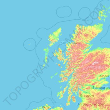
Name: Hebrides topographic map, elevation, terrain.

Location: Hebrides, Scotland, United Kingdom (55.57907 -13.68751 59.13469 -5.42700)

Average elevation: 233 ft

Minimum elevation: 0 ft

Maximum elevation: 4,137 ft

Other topographic maps

Click on a map to view its topography, its elevation and its terrain.

Scottish Highlands

United Kingdom > Scotland > Highland

The Scottish Highlands are renowned for their rugged, mountainous terrain that dominates much of the region. Stretching across the northern and central parts of Scotland, the landscape is shaped by ancient geological forces, including the Caledonian Orogeny, which caused significant tectonic collisions…

Average elevation: 2,976 ft

Edinburgh

United Kingdom > Scotland

Edinburgh has been popularly called the Athens of the North since the early 19th century. References to Athens, such as Athens of Britain and Modern Athens, had been made as early as the 1760s. The similarities were seen to be topographical but also intellectual. Edinburgh's Castle Rock reminded returning…

Average elevation: 341 ft

Rothesay

United Kingdom > Scotland > Argyll and Bute

Average elevation: 125 ft

Gowkshill

United Kingdom > Scotland > Midlothian > Newtongrange

Average elevation: 476 ft

Monifieth

United Kingdom > Scotland > Angus

The name "Monifieth" likely derives from the Gaelic "Moine Feith", "Bogstream of the marsh/moss". Previous suggestions that it comes from "Monadh Fieth" meaning "hill of the deer" make little sense. "Monadh" would mean a large upland mountainous area, which(given that the town is many miles from the highlands)…

Average elevation: 95 ft

Anstruther

United Kingdom > Scotland > Fife

Average elevation: 75 ft

Pitlochry

United Kingdom > Scotland > Perth and Kinross

Average elevation: 906 ft

Portree

United Kingdom > Scotland > Highland

Average elevation: 397 ft

Straiton

United Kingdom > Scotland > South Ayrshire

Average elevation: 610 ft

Kenmore

United Kingdom > Scotland > Perth and Kinross

Average elevation: 758 ft

Wigtown

United Kingdom > Scotland > Dumfries and Galloway

Wigtown Castle was in existence by 1291, on flat land down by the River Bladnoch, (outlines clearly seen on an aerial view), whilst the town and church were on a hill, "an inversion of the usual arrangements". Nothing remains of the castle, although a strong natural site and indication of a large enclosed and…

Average elevation: 59 ft

Braehead Farm

United Kingdom > Scotland > West Lothian > Fauldhouse

Average elevation: 810 ft

Rhu

United Kingdom > Scotland > Argyll and Bute

Average elevation: 220 ft

Hawkstane

United Kingdom > Scotland > Perth and Kinross > Cottown

Average elevation: 82 ft

Eilean Donan

United Kingdom > Scotland > Highland > Dornie > Totaig

In 1689, King James VII of the House of Stuart was declared to have to forfeit the throne, and the crown was offered to William of Orange, in the so-called "Glorious Revolution". The revolution also established Presbyterianism in Scotland, although the Highlands generally remained Roman Catholic and loyal to…

Average elevation: 269 ft

Lochmaddy

United Kingdom > Scotland > Western Isles

Average elevation: 52 ft

Muir of Fowlis

United Kingdom > Scotland > Aberdeenshire

Average elevation: 755 ft

Laide

United Kingdom > Scotland > Highland

Average elevation: 154 ft

Friockheim

United Kingdom > Scotland > Angus

Average elevation: 187 ft

Ayr

United Kingdom > Scotland > South Ayrshire

Average elevation: 59 ft

Bo'ness

United Kingdom > Scotland > Falkirk

Average elevation: 95 ft

Skelmorlie

United Kingdom > Scotland > North Ayrshire

Average elevation: 223 ft

Redpoint

United Kingdom > Scotland > Highland

Average elevation: 121 ft

Forres

United Kingdom > Scotland > Moray

Average elevation: 102 ft

Boddam

United Kingdom > Scotland > Shetland > Dunrossness

Average elevation: 85 ft

Dunbar

United Kingdom > Scotland > East Lothian

Average elevation: 79 ft

Burghead

United Kingdom > Scotland > Moray

Average elevation: 20 ft

Clydebank

United Kingdom > Scotland > West Dunbartonshire

Average elevation: 148 ft

Newburgh

United Kingdom > Scotland > Aberdeenshire

Average elevation: 59 ft

Inver

United Kingdom > Scotland > Perth and Kinross

Average elevation: 528 ft

Fortrose

United Kingdom > Scotland > Highland

Average elevation: 164 ft

Haddington

United Kingdom > Scotland > East Lothian

Average elevation: 256 ft

Salsburgh

United Kingdom > Scotland > North Lanarkshire

Average elevation: 771 ft

Kilmory

United Kingdom > Scotland > Highland

Average elevation: 200 ft

Lochgilphead

United Kingdom > Scotland > Argyll and Bute

Average elevation: 335 ft

Shotts

United Kingdom > Scotland > North Lanarkshire

Average elevation: 758 ft

Elderslie

United Kingdom > Scotland > Renfrewshire

Average elevation: 200 ft

Arbroath

United Kingdom > Scotland > Angus

Average elevation: 79 ft

Newtongrange

United Kingdom > Scotland > Midlothian

Average elevation: 436 ft

Barrmill

United Kingdom > Scotland > North Ayrshire

Average elevation: 328 ft

Sciberscross

United Kingdom > Scotland > Highland

Average elevation: 551 ft

Busby

United Kingdom > Scotland > East Renfrewshire

Average elevation: 341 ft

Macmerry

United Kingdom > Scotland > East Lothian

Average elevation: 299 ft

Torsa

United Kingdom > Scotland > Argyll and Bute > Cuan > Silver Moon

Average elevation: 39 ft

Campbeltown

United Kingdom > Scotland > Argyll and Bute

Average elevation: 276 ft

Coupar Angus

United Kingdom > Scotland > Perth and Kinross

Average elevation: 230 ft

Tigharry

United Kingdom > Scotland > Western Isles

Average elevation: 36 ft

Kinnesswood

United Kingdom > Scotland > Perth and Kinross

Average elevation: 627 ft

Dundee

United Kingdom > Scotland > Dundee City

Dundee sits on the north bank of the Firth of Tay on the eastern, North Sea Coast of Scotland. The city lies 36.1 miles (58 km) NNE of Edinburgh and 360.6 miles (580 km) NNW of London. The built-up area occupies a roughly rectangular shape 8.3 miles (13 km) long by 2.5 miles (4 km) wide, aligned in an east to…

Average elevation: 269 ft

Island

United Kingdom > Scotland > Shetland > Mid Yell

Average elevation: 66 ft

Texa

United Kingdom > Scotland > Argyll and Bute

Average elevation: 3 ft

Ailsa Craig

United Kingdom > Scotland

In a small glen above Ailsa Castle, a small freshwater body known as the Garry Loch is located at an altitude of 247 m (810 ft), with a depth of at least 17 feet.

Average elevation: 46 ft

West Clifton

United Kingdom > Scotland > City of Edinburgh

Average elevation: 305 ft

Lewiston

United Kingdom > Scotland > Highland

Average elevation: 417 ft

Peterculter

United Kingdom > Scotland > Aberdeen City

Average elevation: 200 ft

Fodderty

United Kingdom > Scotland > Highland

Average elevation: 423 ft

Stirling

United Kingdom > Scotland

Average elevation: 797 ft

Kingussie

United Kingdom > Scotland > Highland

Average elevation: 1,109 ft

Livingston

United Kingdom > Scotland > West Lothian

Average elevation: 518 ft

Reef

United Kingdom > Scotland > Western Isles

Average elevation: 59 ft

Forgue

United Kingdom > Scotland > Aberdeenshire

Average elevation: 371 ft

Newtonmore

United Kingdom > Scotland > Highland

Newtonmore is located within the Cairngorms National Park, approximately 3 miles (5 km) southwest of Kingussie and 15 miles (24 km) southwest of Aviemore. It is on the northeastern bank of the River Spey, between the River Calder and the Allt Lairaidh, at an altitude of approximately 250 metres (820 ft).

Average elevation: 928 ft

Stirling

United Kingdom > Scotland

Average elevation: 1,785 ft

Sandness

United Kingdom > Scotland > Shetland

Average elevation: 157 ft

Auchtermuchty

United Kingdom > Scotland > Fife

Average elevation: 354 ft

Salen

United Kingdom > Scotland > Argyll and Bute

Average elevation: 177 ft

Sanquhar

United Kingdom > Scotland > Dumfries and Galloway

Average elevation: 797 ft

Castlelaw

United Kingdom > Scotland > Midlothian

Average elevation: 889 ft

Tornagrain

United Kingdom > Scotland > Highland > Inverness

Average elevation: 151 ft

Scarista

United Kingdom > Scotland > Western Isles

Average elevation: 197 ft

Blacklunans

United Kingdom > Scotland > Perth and Kinross

Average elevation: 1,171 ft

Glenlivet

United Kingdom > Scotland > Moray

Average elevation: 919 ft

Bearsden

United Kingdom > Scotland > East Dunbartonshire

Average elevation: 236 ft

Braemar

United Kingdom > Scotland > Aberdeenshire

Braemar /breɪˈmɑːr/ (listen) is a village in Aberdeenshire, Scotland, around 58 miles (93 km) west of Aberdeen in the Highlands. It is the closest significantly-sized settlement to the upper course of the River Dee sitting at an elevation of 339 metres (1,112 ft).

Average elevation: 1,460 ft

Montrose

United Kingdom > Scotland > Angus

Montrose occupies a position on the North Bank of Montrose Basin at the mouth of the River South Esk on the East Coast of Scotland, 11 miles (18 km) NNE of Arbroath, 19 miles (31 km) SW of Stonehaven, and 7.2 miles (12 km) ESE of Brechin. The town lies 62.2 miles (100 km) NNE of Edinburgh, and 373.2 miles (601…

Average elevation: 72 ft

Peebles

United Kingdom > Scotland > Scottish Borders

Average elevation: 902 ft

Clachan

United Kingdom > Scotland > Argyll and Bute

Average elevation: 246 ft

Brechin

United Kingdom > Scotland > Angus

Average elevation: 233 ft

Darvel

United Kingdom > Scotland > East Ayrshire

Average elevation: 702 ft

Buachaille Etive Mor

United Kingdom > Scotland > Highland

Average elevation: 1,857 ft

Dufftown

United Kingdom > Scotland > Moray

Average elevation: 879 ft

Ullapool

United Kingdom > Scotland > Highland

Average elevation: 492 ft

Tranent

United Kingdom > Scotland > East Lothian

Average elevation: 203 ft

Jedburgh

United Kingdom > Scotland > Scottish Borders

Average elevation: 495 ft

Crathie

United Kingdom > Scotland > Aberdeenshire

Average elevation: 1,178 ft

Cambuslang

United Kingdom > Scotland > South Lanarkshire

Average elevation: 230 ft

Selkirk

United Kingdom > Scotland > Scottish Borders

Average elevation: 741 ft

Stepps

United Kingdom > Scotland > North Lanarkshire

Average elevation: 240 ft

Blantyre

United Kingdom > Scotland > South Lanarkshire

Average elevation: 276 ft

Bilston

United Kingdom > Scotland > Midlothian

Average elevation: 554 ft

Dryden Farm

United Kingdom > Scotland > Midlothian > Loanhead

Average elevation: 472 ft

Cairn Gorm

United Kingdom > Scotland > Highland

Cairn Gorm (Scottish Gaelic: An Càrn Gorm) is a mountain in the Scottish Highlands. It is part of the Cairngorms range and wider Grampian Mountains. With a summit elevation of 1,245 m (4,085 ft) above sea level, Cairn Gorm is classed as a Munro and is the sixth-highest mountain in the British Isles. The high,…

Average elevation: 3,245 ft

Cupar

United Kingdom > Scotland > Fife

Average elevation: 246 ft

Bridgefoot

United Kingdom > Scotland > Angus

Average elevation: 410 ft

Falkirk

United Kingdom > Scotland > Falkirk

Falkirk is located in an area of undulating topography between the Slamannan Plateau and the upper reaches of the Firth of Forth. The area to the north of Falkirk is part of the floodplain of the River Carron. Two tributaries of the River Carron - the East Burn and the West Burn flow through the town and form…

Average elevation: 226 ft

Corse Hill

United Kingdom > Scotland > Aberdeenshire

Average elevation: 1,047 ft

Gear up for your next adventure:

🏕️Tent Footprint - Protect your tent base from wear
🎒Trekking Poles - Sturdy poles for balance and stability on rough terrain
🪶Thermal Camp Blanket - Extra warmth for cold nights
📚USA Hiking Guide Books - Top trail guides and map books
👟Trail Running Shoes - Lightweight shoes for trail runners

As an Amazon Associate, this site earns from qualifying purchases at no extra cost to you.