Crow Wing County topographic map
Interactive map
Click on the map to display elevation.
About this map
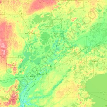
Name: Crow Wing County topographic map, elevation, terrain.
Location: Crow Wing County, Minnesota, United States (46.15592 -94.39572 46.80553 -93.77602)
Average elevation: 1,266 ft
Minimum elevation: 1,138 ft
Maximum elevation: 1,545 ft
Crow Wing County has two state forests, the Crow Wing State Forest and the Emily State Forest. The Cuyuna Lakes State Trail lies in the Upper Mississippi River Basin. The topography is gently rolling to flat, mostly wooded and heavily dotted with waters and wetlands. It is home to an abundance of wildlife, including white-tailed deer, cottontail rabbit, snowshoe hare, raccoon, red fox, gray fox, coyote, mink, muskrat, squirrels, beaver, occasional American black bear, Bald eagle, osprey and many other waterfowl.
Other topographic maps
Click on a map to view its topography, its elevation and its terrain.
Minneapolis
United States > Minnesota > Hennepin County
Minneapolis, Hennepin County, Minnesota, United States
Average elevation: 886 ft
Duluth
United States > Minnesota > Saint Louis County
Duluth, Saint Louis County, Minnesota, United States
Average elevation: 938 ft
Rochester
United States > Minnesota > Olmsted County
Rochester, Olmsted County, Minnesota, United States
Average elevation: 1,161 ft
Saint Paul
United States > Minnesota > Ramsey County
Saint Paul, Ramsey County, Minnesota, United States
Average elevation: 879 ft
Minneapolis
United States > Minnesota > Hennepin County > Minneapolis
Minneapolis, Hennepin County, Minnesota, 55488, United States
Average elevation: 889 ft
Bloomington
United States > Minnesota > Hennepin County
Bloomington, Hennepin County, Minnesota, United States
Average elevation: 837 ft
Mankato
United States > Minnesota > Blue Earth County
Mankato, Blue Earth County, Minnesota, 56001, United States
Average elevation: 935 ft
Bodum
United States > Minnesota > Isanti County
Bodum, Isanti Township, Isanti County, Minnesota, 55008, United States
Average elevation: 965 ft
Wyanett
United States > Minnesota > Isanti County
Wyanett, Wyanett Township, Isanti County, Minnesota, United States
Average elevation: 961 ft
West Point
United States > Minnesota > Isanti County
West Point, Spencer Brook Township, Isanti County, Minnesota, United States
Average elevation: 942 ft
Weber
United States > Minnesota > Isanti County
Weber, North Branch Township, Isanti County, Minnesota, United States
Average elevation: 925 ft
Walbo
United States > Minnesota > Isanti County
Walbo, Springvale Township, Isanti County, Minnesota, United States
Average elevation: 938 ft
Stanley
United States > Minnesota > Isanti County
Stanley, Isanti Township, Isanti County, Minnesota, United States
Average elevation: 961 ft
Stanchfield Corner
United States > Minnesota > Isanti County
Stanchfield Corner, Stanchfield Township, Isanti County, Minnesota, 55080, United States
Average elevation: 942 ft
Springvale
United States > Minnesota > Isanti County
Springvale, Springvale Township, Isanti County, Minnesota, United States
Average elevation: 945 ft
Spring Lake
United States > Minnesota > Isanti County
Spring Lake, North Branch Township, Isanti County, Minnesota, United States
Average elevation: 938 ft
Spencer Brook
United States > Minnesota > Isanti County
Spencer Brook, Spencer Brook Township, Isanti County, Minnesota, United States
Average elevation: 948 ft
Pine Brook
United States > Minnesota > Isanti County
Pine Brook, Springvale Township, Isanti County, Minnesota, United States
Average elevation: 955 ft
Oxlip
United States > Minnesota > Isanti County
Oxlip, Bradford Township, Isanti County, Minnesota, United States
Average elevation: 945 ft
Grandy
United States > Minnesota > Isanti County
Grandy, Cambridge Township, Isanti County, Minnesota, 55029, United States
Average elevation: 935 ft
Elm Park
United States > Minnesota > Isanti County
Elm Park, Maple Ridge Township, Isanti County, Minnesota, United States
Average elevation: 951 ft
Edgewood
United States > Minnesota > Isanti County
Edgewood, Isanti Township, Isanti County, Minnesota, 55008, United States
Average elevation: 948 ft
Day
United States > Minnesota > Isanti County
Day, Maple Ridge Township, Isanti County, Minnesota, United States
Average elevation: 991 ft
Dalbo
United States > Minnesota > Isanti County
Dalbo, Dalbo Township, Isanti County, Minnesota, 55017, United States
Average elevation: 971 ft
Crown
United States > Minnesota > Isanti County
Crown, Stanford Township, Isanti County, Minnesota, United States
Average elevation: 968 ft
Carmody
United States > Minnesota > Isanti County
Carmody, Dalbo Township, Isanti County, Minnesota, 55017, United States
Average elevation: 981 ft
Blomford
United States > Minnesota > Isanti County
Blomford, Isanti Township, Isanti County, Minnesota, United States
Average elevation: 951 ft
Andree
United States > Minnesota > Isanti County
Andree, Stanchfield Township, Isanti County, Minnesota, 55006, United States
Average elevation: 955 ft
Stanchfield
United States > Minnesota > Isanti County
Stanchfield, Stanchfield Township, Isanti County, Minnesota, 55080, United States
Average elevation: 942 ft
Isanti
United States > Minnesota > Isanti County
Isanti, Isanti County, Minnesota, United States
Average elevation: 935 ft
Bradford
United States > Minnesota > Isanti County
Bradford, Bradford Township, Isanti County, Minnesota, United States
Average elevation: 942 ft
Athens
United States > Minnesota > Isanti County
Athens, Athens Township, Isanti County, Minnesota, 55040, United States
Average elevation: 932 ft
West St. Paul
United States > Minnesota > Dakota County
West St. Paul, Dakota County, Minnesota, 55118, United States
Average elevation: 965 ft
Olmsted County
Olmsted County, Minnesota, United States
Average elevation: 1,161 ft
Maple Grove
United States > Minnesota > Hennepin County
Maple Grove, Hennepin County, Minnesota, United States
Average elevation: 912 ft
St. Vincent
United States > Minnesota > Kittson County
St. Vincent, Kittson County, Minnesota, 56755, United States
Average elevation: 791 ft
Eagan
United States > Minnesota > Dakota County
Eagan, Dakota County, Minnesota, United States
Average elevation: 876 ft
Wayzata
United States > Minnesota > Hennepin County
Wayzata, Hennepin County, Minnesota, United States
Average elevation: 955 ft
Tonka Bay
United States > Minnesota > Hennepin County
Tonka Bay, Hennepin County, Minnesota, United States
Average elevation: 938 ft
Minnetonka Beach
United States > Minnesota > Hennepin County
Minnetonka Beach, Hennepin County, Minnesota, United States
Average elevation: 932 ft
Eitzen
United States > Minnesota > Houston County
Eitzen, Houston County, Minnesota, United States
Average elevation: 1,122 ft
La Crescent
United States > Minnesota > Houston County
La Crescent, Houston County, Minnesota, 55947, United States
Average elevation: 758 ft
Emmons
United States > Minnesota > Freeborn County
Emmons, Freeborn County, Minnesota, United States
Average elevation: 1,273 ft
Independence
United States > Minnesota > Hennepin County
Independence, Hennepin County, Minnesota, 55359, United States
Average elevation: 978 ft
Loretto
United States > Minnesota > Hennepin County
Loretto, Hennepin County, Minnesota, United States
Average elevation: 1,014 ft
Maple Plain
United States > Minnesota > Hennepin County
Maple Plain, Hennepin County, Minnesota, United States
Average elevation: 997 ft
Bee
United States > Minnesota > Houston County
Bee, Houston County, Minnesota, United States
Average elevation: 1,063 ft
River Junction
United States > Minnesota > Houston County > La Crescent
River Junction, La Crescent, Houston County, Minnesota, 55947, United States
Average elevation: 764 ft
Corcoran
United States > Minnesota > Hennepin County
Corcoran, Hennepin County, Minnesota, United States
Average elevation: 958 ft
Greenwood
United States > Minnesota > Hennepin County
Greenwood, Hennepin County, Minnesota, United States
Average elevation: 948 ft