
Llanera topographic map
Interactive map
Click on the map to display elevation.
About this map
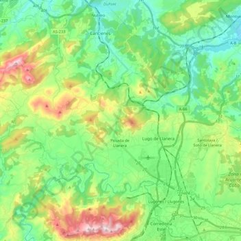
Name: Llanera topographic map, elevation, terrain.
Location: Llanera, Asturias, Spain (43.40782 -5.96855 43.50110 -5.75620)
Average elevation: 646 ft
Minimum elevation: 39 ft
Maximum elevation: 2,051 ft
Other topographic maps
Click on a map to view its topography, its elevation and its terrain.
Arriondas / Les Arriondes
Spain > Asturias > Parres > Arriondas / Les Arriondes
Average elevation: 614 ft
Bulnes de Arriba (El Castillo)
Spain > Asturias > Cabrales > Bulnes de Arriba (El Castillo)
Average elevation: 3,734 ft