
Bessans topographic map
Interactive map
Click on the map to display elevation.
Bessans
Located on the Haute-Maurienne plateau, at an altitude of 1750 meters, the area is known for its sporting activities. Bessans is located in a valley, ideal for Nordic skiing. Following the collapse of the mountain downstream from Bessans (between 10000 and 3000 years BC), an ice-dammed lake formed. The successive sedimentary deposits have created the plateau on which Bessans is situated. The physical characteristics of the site are reinforced by an early and high-quality snow from November to April, and by sunny weather. These allow the team French Nordic skiing and Biathlon teams, as well as those of other nations to train in Bessans
About this map
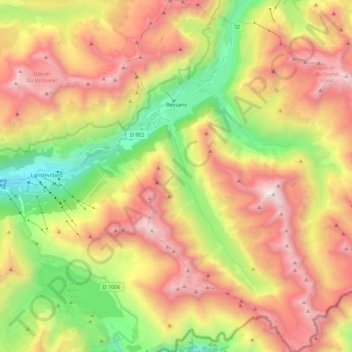
Name: Bessans topographic map, elevation, terrain.
Average elevation: 8,307 ft
Minimum elevation: 4,603 ft
Maximum elevation: 12,241 ft
Other topographic maps
Click on a map to view its topography, its elevation and its terrain.
Mollard Durand
France > Auvergne-Rhône-Alpes > Savoy > Saint-Martin-de-la-Porte
Average elevation: 3,445 ft
Le Charvet
France > Auvergne-Rhône-Alpes > Savoy > Bourg-Saint-Maurice > Arc 1800
Average elevation: 5,417 ft
Les Ménuires
France > Auvergne-Rhône-Alpes > Savoy
The resort was founded in 1964 and has an altitude range of 1,850 m (6,070 ft).
Average elevation: 6,768 ft
La Chiserette
France > Auvergne-Rhône-Alpes > Savoy > Champagny-en-Vanoise
Average elevation: 6,329 ft
Dou des Ponts
France > Auvergne-Rhône-Alpes > Savoy > Pralognan-la-Vanoise
Average elevation: 6,243 ft
Le Laisonnay d'En Bas
France > Auvergne-Rhône-Alpes > Savoy > Champagny-en-Vanoise
Average elevation: 7,021 ft
La Chenolaz
France > Auvergne-Rhône-Alpes > Savoy > Saint-Pierre-d'Albigny
Average elevation: 2,195 ft
Le Désert d'Entremont
France > Auvergne-Rhône-Alpes > Savoy > Entremont-le-Vieux
Average elevation: 3,809 ft
Le Grand Couloir
France > Auvergne-Rhône-Alpes > Savoy > Pralognan-la-Vanoise
Average elevation: 6,155 ft
La Ville des Glaciers
France > Auvergne-Rhône-Alpes > Savoy > Bourg-Saint-Maurice
Average elevation: 7,152 ft