
San Bernardino National Forest topographic map
Interactive map
Click on the map to display elevation.
San Bernardino National Forest
The San Bernardino National Forest is a United States National Forest in Southern California encompassing 823,816 acres (3,333.87 km2) of which 677,982 acres (2,743.70 km2) are federal. The forest is made up of two main divisions, the eastern portion of the San Gabriel Mountains and the San Bernardino Mountains on the easternmost of the Transverse Ranges, and the San Jacinto and Santa Rosa Mountains on the northernmost of the Peninsular Ranges. Elevations range from 2,000 to 11,499 feet (600 to 3505 m). The forest includes seven wilderness areas: San Gorgonio, Cucamonga, San Jacinto, South Fork, Santa Rosa, Cahuilla Mountain and Bighorn Mountain. Forest headquarters are located in the city of San Bernardino. There are district offices in Lytle Creek, Idyllwild, and Fawnskin.
About this map
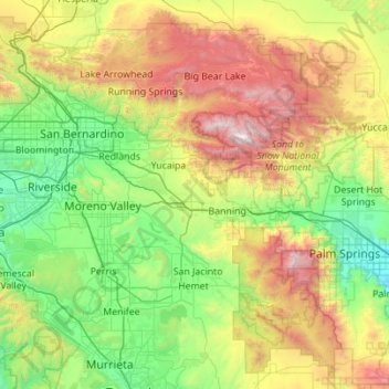
Name: San Bernardino National Forest topographic map, elevation, terrain.
Average elevation: 3,310 ft
Minimum elevation: 233 ft
Maximum elevation: 11,440 ft
Riverside County trails, hiking, mountain biking, running and outdoor activities
Other topographic maps
Click on a map to view its topography, its elevation and its terrain.
Idyllwild-Pine Cove
United States > California > Riverside County
"Mile-high Idyllwild" is a mountain resort about one-mile (1,600 m) in altitude. Idyllwild is flanked by two large rock formations, Tahquitz Peak and Suicide Rock (also known as Lily Rock), which are famous in Southern California rock-climbing circles. It offers no skiing, so "the Hill" has been minimally…
Average elevation: 5,728 ft
Menifee
United States > California > Riverside County
Menifee is a city in Riverside County, California, United States, and part of the Los Angeles Combined Statistical Area. The city is centrally located in Southern California in the Menifee Valley. It is almost 15 miles (24 km) north of Temecula and just north of Murrieta. Menifee is roughly 46 square miles…
Average elevation: 1,496 ft
El Cerrito
United States > California > Riverside County
According to the United States Census Bureau, the city has a total area of 3.7 square miles (9.6 km2), all of it land. The city ranges in elevation from 20 to 934 feet, with an average elevation of 69 feet (21 m).
Average elevation: 961 ft
Agua Caliente Park
United States > California > Riverside County > Cathedral City
Average elevation: 397 ft
Mountain Center
United States > California > Riverside County
It lies centered on the junction of State Route 74 and State Route 243 in the southern division of San Bernardino National Forest. Mountain Center lies just north of Lake Hemet, midway between Hemet and Palm Desert, just south of the town of Idyllwild, and it is southeast of the city of Riverside, the county…
Average elevation: 4,843 ft
San Gorgonio Pass
United States > California > Riverside County
The San Gorgonio Pass, or Banning Pass, is a 2,600 ft (790 m) elevation gap on the rim of the Great Basin between the San Bernardino Mountains to the north and the San Jacinto Mountains to the south. The pass was formed by the San Andreas Fault, a major transform fault between the Pacific plate and the North…
Average elevation: 1,614 ft
Highgrove
United States > California > Riverside County
The city of Riverside, California has plans to annex Highgrove in the near future. Currently at Spring Mountain Ranch community, Avalon, Cambria, and Sonoma (all opening by February 2022) are the three, newest largest master-planned communities being built at the Highgrove eastside area. Soon, Compass and…
Average elevation: 1,037 ft
Arlington Station
United States > California > Riverside County > Riverside
Arlington Station (formerly, Arlington) is a former unincorporated community, now annexed to Riverside in Riverside County, California. It lies at an elevation of 817 feet (249 m). Arlington Station is located on the Atchison, Topeka and Santa Fe Railroad, 6 miles (9.7 km) southwest of downtown Riverside.
Average elevation: 827 ft
Sunnymead Ranch Lake
United States > California > Riverside County > Moreno Valley
Average elevation: 1,886 ft
Colorado River
United States > California > Riverside County
The entire eastern boundary of the Colorado River Basin runs along the North American Continental Divide and is defined largely by the Rocky Mountains and the Rio Grande Basin. The Wind River Range in Wyoming marks the northern extent of the basin, and is separated from the Colorado Rockies by the endorheic…
Average elevation: 305 ft
Bogart County Park
United States > California > Riverside County > Highland Springs
Average elevation: 3,192 ft
Pine Cove
United States > California > Riverside County > Idyllwild-Pine Cove
Average elevation: 5,876 ft
Cahuilla Hills
United States > California > Riverside County > Palm Desert
Average elevation: 1,211 ft
Bannockburn Village
United States > California > Riverside County > Riverside > Bannockburn Village
Average elevation: 1,102 ft
Pinyon Pines
United States > California > Riverside County
It is located in a small valley between the San Jacinto Mountains and Santa Rosa Mountains, north of State Route 74. It takes its name from the Pinyon pine (Pinus monophylla) trees native to the area. Pinyon Pines sits at an elevation of approximately 4000 feet.
Average elevation: 4,186 ft
Beaumont
United States > California > Riverside County > Beaumont > Beaumont
Average elevation: 2,582 ft
Moreno Valley
United States > California > Riverside County > Moreno Valley
Average elevation: 1,621 ft
Garnet
United States > California > Riverside County > Palm Springs > Garnet
Average elevation: 735 ft