
Door County topographic map
Interactive map
Click on the map to display elevation.
Door County
The 102-foot-high (31 m) Brussels Hill (44°45′06″N 87°35′27″W / 44.75166°N 87.59093°W / 44.75166; -87.59093 (Brussels Hill), elevation 851 feet [259 m]) is the highest point in the county. The nearby Red Hill Woods is the largest remaining maple–beech forest in the area.
About this map
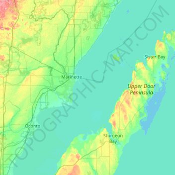
Name: Door County topographic map, elevation, terrain.
Location: Door County, Wisconsin, United States (44.67496 -87.73686 45.42985 -86.76408)
Average elevation: 627 ft
Minimum elevation: 564 ft
Maximum elevation: 1,033 ft
Wisconsin trails, hiking, mountain biking, running and outdoor activities
Other topographic maps
Click on a map to view its topography, its elevation and its terrain.
Rib Mountain State Park
United States > Wisconsin > Marathon County > Wausau
Average elevation: 1,332 ft
Sheboygan Marsh 2 WP 319 Dam
United States > Wisconsin > Sheboygan County > Town of Russell
Average elevation: 932 ft
Observatory Hill State Natural Area
United States > Wisconsin > Marquette County
Average elevation: 860 ft
McAllister
United States > Wisconsin > Marinette County
McAllister is located at the intersection of Wisconsin Highway 180 and County Highway JJ 11.5 miles (18.5 km) east-southeast of Wausaukee at an elevation of 692 feet (211 m). It is connected by road to Wausaukee to the west, Packard to the north, Wagner to the south, and Wallace, Michigan, to the east via a…
Average elevation: 689 ft
Wilderness Lake
United States > Wisconsin > Bayfield County > Town of Drummond
Average elevation: 1,283 ft
Milwaukee River Floodplain Forest State Natural Area
United States > Wisconsin > Washington County
Average elevation: 955 ft
Marinette County Beech Forest State Natural Area
United States > Wisconsin > Marinette County
Average elevation: 1,217 ft
Isthmus Path Prairie Garden
United States > Wisconsin > Dane County > Madison
Average elevation: 860 ft
Yellowstone Lake State Park
United States > Wisconsin > Lafayette County > Blanchardville > Town of Fayette
Average elevation: 945 ft
Lake Adelade
United States > Wisconsin > Vilas County > Town of Winchester
Average elevation: 1,667 ft
Village of West Salem
United States > Wisconsin > La Crosse County > West Salem
Average elevation: 741 ft
Black River Falls
United States > Wisconsin > Jackson County > Black River Falls
Average elevation: 866 ft
Menomonee Falls
United States > Wisconsin > Waukesha County > Menomonee Falls
Average elevation: 853 ft
Pleasant Prairie
United States > Wisconsin > Kenosha County > Pleasant Prairie
Average elevation: 715 ft
McAllister
United States > Wisconsin > Marinette County > Town of Wagner
McAllister is located at the intersection of Wisconsin Highway 180 and County Highway JJ 11.5 miles (18.5 km) east-southeast of Wausaukee at an elevation of 692 feet (211 m). It is connected by road to Wausaukee to the west, Packard to the north, Wagner to the south, and Wallace, Michigan, to the east via a…
Average elevation: 689 ft