
Make a donation
Gear up for your next adventure:
As an Amazon Associate, this site earns from qualifying purchases at no extra cost to you.
Avoyelles Parish topographic map
Click on the map to display elevation.
Make a donation
Gear up for your next adventure:
As an Amazon Associate, this site earns from qualifying purchases at no extra cost to you.
About this map
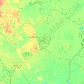
Name: Avoyelles Parish topographic map, elevation, terrain.
Location: Avoyelles Parish, Louisiana, United States (30.84765 -92.28114 31.34395 -91.67784)
Average elevation: 52 ft
Minimum elevation: 16 ft
Maximum elevation: 128 ft
Louisiana trails, hiking, mountain biking, running and outdoor activities
Make a donation
Gear up for your next adventure:
As an Amazon Associate, this site earns from qualifying purchases at no extra cost to you.
Other topographic maps
Click on a map to view its topography, its elevation and its terrain.
Evangeline Hermitage Estates
United States > Louisiana > East Baton Rouge Parish
Average elevation: 26 ft
Lakeview
United States > Louisiana > Orleans Parish > New Orleans
Lakeview is located at 30°00′24″N 90°06′28″W / 30.00667°N 90.10778°W / 30.00667; -90.10778 and has an elevation of 0 feet (0.0 m). According to the United States Census Bureau, the district has a total area of 1.61 square miles (4.2 km2). 1.61 square miles (4.2 km2) of which is land and…
Average elevation: 7 ft
Make a donation
Gear up for your next adventure:
As an Amazon Associate, this site earns from qualifying purchases at no extra cost to you.
Make a donation
Gear up for your next adventure:
As an Amazon Associate, this site earns from qualifying purchases at no extra cost to you.
Lake Sherwood Acres
United States > Louisiana > East Baton Rouge Parish > Baton Rouge
Average elevation: 46 ft
Make a donation
Gear up for your next adventure:
As an Amazon Associate, this site earns from qualifying purchases at no extra cost to you.
Marwede Place
United States > Louisiana > East Baton Rouge Parish > Baton Rouge
Average elevation: 56 ft
Make a donation
Gear up for your next adventure:
As an Amazon Associate, this site earns from qualifying purchases at no extra cost to you.
Make a donation
Gear up for your next adventure:
As an Amazon Associate, this site earns from qualifying purchases at no extra cost to you.
Make a donation
Gear up for your next adventure:
As an Amazon Associate, this site earns from qualifying purchases at no extra cost to you.
New Orleans
United States > Louisiana > Orleans Parish
Founded in 1718 by French colonists, New Orleans was once the territorial capital of French Louisiana before becoming part of the United States in the Louisiana Purchase of 1803. New Orleans in 1840 was the third most populous city in the United States, and it was the largest city in the American South from…
Average elevation: 3 ft
Make a donation
Gear up for your next adventure:
As an Amazon Associate, this site earns from qualifying purchases at no extra cost to you.
Algiers Point
United States > Louisiana > Orleans Parish > New Orleans > Algiers
Average elevation: 10 ft
Make a donation
Gear up for your next adventure:
As an Amazon Associate, this site earns from qualifying purchases at no extra cost to you.
Make a donation
Gear up for your next adventure:
As an Amazon Associate, this site earns from qualifying purchases at no extra cost to you.
Make a donation
Gear up for your next adventure:
As an Amazon Associate, this site earns from qualifying purchases at no extra cost to you.
South Baton Rouge
United States > Louisiana > East Baton Rouge Parish > Baton Rouge
Average elevation: 43 ft
Mimosa Baseball and Tennis park
United States > Louisiana > St. Charles Parish > Luling > Mimosa Park
Average elevation: 10 ft
Make a donation
Gear up for your next adventure:
As an Amazon Associate, this site earns from qualifying purchases at no extra cost to you.
Liberty Farms
United States > Louisiana > East Baton Rouge Parish > Baton Rouge
Average elevation: 69 ft
Make a donation
Gear up for your next adventure:
As an Amazon Associate, this site earns from qualifying purchases at no extra cost to you.
Make a donation
Gear up for your next adventure:
As an Amazon Associate, this site earns from qualifying purchases at no extra cost to you.
Make a donation
Gear up for your next adventure:
As an Amazon Associate, this site earns from qualifying purchases at no extra cost to you.
Make a donation
Gear up for your next adventure:
As an Amazon Associate, this site earns from qualifying purchases at no extra cost to you.
Make a donation
Gear up for your next adventure:
As an Amazon Associate, this site earns from qualifying purchases at no extra cost to you.
Mississippi River
United States > Louisiana > West Feliciana Parish
The uppermost lock and dam on the Upper Mississippi River is the Upper St. Anthony Falls Lock and Dam in Minneapolis. Above the dam, the river's elevation is 799 feet (244 m). Below the dam, the river's elevation is 750 feet (230 m). This 49-foot (15 m) drop is the largest of all the Mississippi River locks…
Average elevation: 43 ft
Make a donation
Gear up for your next adventure:
As an Amazon Associate, this site earns from qualifying purchases at no extra cost to you.
Holiday Acres
United States > Louisiana > East Baton Rouge Parish > Baton Rouge
Average elevation: 72 ft
Make a donation
Gear up for your next adventure:
As an Amazon Associate, this site earns from qualifying purchases at no extra cost to you.
Prescott Place
United States > Louisiana > East Baton Rouge Parish > Baton Rouge
Average elevation: 66 ft
Tensas River National Wildlife Refuge
United States > Louisiana > Tensas Parish
Average elevation: 75 ft
Make a donation
Gear up for your next adventure:
As an Amazon Associate, this site earns from qualifying purchases at no extra cost to you.
Sherwood Oaks
United States > Louisiana > East Baton Rouge Parish > Baton Rouge
Average elevation: 46 ft
Bossier City
United States > Louisiana > Bossier Parish
Bossier City is located at 32°31′4″N 93°41′29″W / 32.51778°N 93.69139°W / 32.51778; -93.69139 (32.517651, −93.691397) within the Ark-La-Tex and has an elevation of 174 feet (53.0 m) above sea level. The city lies primarily on the banks of the Red River, and has a largely flat topography…
Average elevation: 180 ft
Make a donation
Gear up for your next adventure:
As an Amazon Associate, this site earns from qualifying purchases at no extra cost to you.
Make a donation
Gear up for your next adventure:
As an Amazon Associate, this site earns from qualifying purchases at no extra cost to you.
Make a donation
Gear up for your next adventure:
As an Amazon Associate, this site earns from qualifying purchases at no extra cost to you.
Covington
United States > Louisiana > St. Tammany Parish > Covington > Covington
Average elevation: 30 ft
Lower Garden District
United States > Louisiana > Orleans Parish > New Orleans > Lower Garden District
Lower Garden District is located at 29°56′02″N 90°04′12″W / 29.93389°N 90.07000°W / 29.93389; -90.07000 and has an elevation of 6 feet (1.8 m). According to the United States Census Bureau, the district has a total area of 1.16 square miles (3.0 km2), 0.95 square miles (2.5 km2) of which…
Average elevation: 10 ft
Make a donation
Gear up for your next adventure:
As an Amazon Associate, this site earns from qualifying purchases at no extra cost to you.
Make a donation
Gear up for your next adventure:
As an Amazon Associate, this site earns from qualifying purchases at no extra cost to you.
Faubourg Marigny
United States > Louisiana > New Orleans > Faubourg Marigny
The Faubourg Marigny is located at 29°57′53″N 90°03′19″W / 29.96472°N 90.05528°W / 29.96472; -90.05528 and has an elevation of 1 foot (0.3 m). According to the United States Census Bureau, the district has a total area of 0.33 square miles (0.9 km2). 0.31 square miles (0.8 km2) of which is…
Average elevation: 7 ft
Make a donation
Gear up for your next adventure:
As an Amazon Associate, this site earns from qualifying purchases at no extra cost to you.