
Calumet County topographic map
Interactive map
Click on the map to display elevation.
Calumet County
According to the U.S. Census Bureau, the county has a total area of 397 square miles (1,030 km2), of which 318 square miles (820 km2) is land and 79 square miles (200 km2) (20%) is water. It is the fifth-smallest county in Wisconsin by land area and fourth-smallest by total area. The west boundary is largely in Lake Winnebago. The Niagara Escarpment runs north–south several miles east of the western boundary. The topography has been greatly influenced by glaciation.
About this map
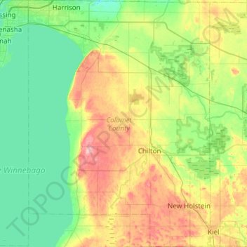
Name: Calumet County topographic map, elevation, terrain.
Location: Calumet County, Wisconsin, United States (43.89145 -88.40443 44.24410 -88.04162)
Average elevation: 843 ft
Minimum elevation: 712 ft
Maximum elevation: 1,142 ft
Wisconsin trails, hiking, mountain biking, running and outdoor activities
Other topographic maps
Click on a map to view its topography, its elevation and its terrain.
Madison
United States > Wisconsin > Dane County
The city is sometimes described as The City of Four Lakes, comprising the four successive lakes of the Yahara River: Lake Mendota ("Fourth Lake"), Lake Monona ("Third Lake"), Lake Waubesa ("Second Lake") and Lake Kegonsa ("First Lake"), although Waubesa and Kegonsa are not actually in Madison, but just south…
Average elevation: 948 ft
Lynn
United States > Wisconsin > Clark County
The history of Lynn, Wisconsin is deeply rooted in the early settlement and development of Clark County. Topics covered in the history of Clark County, Wisconsin, include topography, Indians, early government, early settlement, politics, lumbering, transportation, agriculture, education, the press, the courts,…
Average elevation: 1,165 ft
Northern Wisconsin State Fairgrounds
United States > Wisconsin > Chippewa County > Chippewa Falls
Average elevation: 915 ft
Cleghorn
United States > Wisconsin > Eau Claire County > Town of Pleasant Valley
Average elevation: 1,007 ft
Kickapoo River State Wildlife Area
United States > Wisconsin > Crawford County > Bell Center
Average elevation: 820 ft
Grafton Centennial Park
United States > Wisconsin > Ozaukee County > Grafton
Average elevation: 761 ft
Mississippi River
United States > Wisconsin > Grant County > Dubuque
The uppermost lock and dam on the Upper Mississippi River is the Upper St. Anthony Falls Lock and Dam in Minneapolis. Above the dam, the river's elevation is 799 feet (244 m). Below the dam, the river's elevation is 750 feet (230 m). This 49-foot (15 m) drop is the largest of all the Mississippi River locks…
Average elevation: 666 ft
Mount Hellen
United States > Wisconsin > Saint Croix County > Town of Saint Joseph
Average elevation: 925 ft
Johnstown Center
United States > Wisconsin > Rock County > Town of Johnstown
Average elevation: 951 ft