
Molson topographic map
Interactive map
Click on the map to display elevation.
About this map
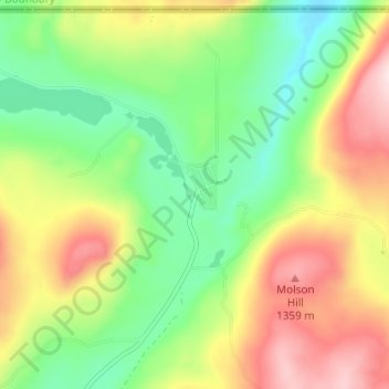
Name: Molson topographic map, elevation, terrain.
Location: Molson, Okanogan County, Washington, United States (48.96102 -119.22060 49.00102 -119.18060)
Average elevation: 3,957 ft
Minimum elevation: 3,474 ft
Maximum elevation: 4,619 ft
Okanogan County trails, hiking, mountain biking, running and outdoor activities
Other topographic maps
Click on a map to view its topography, its elevation and its terrain.
Grand Coulee Dam
United States > Washington > Okanogan County
After power shortages in the Northwest during the 1960s, it was determined the six remaining planned pumps be pump-generators. When energy demand is high, the pump-generators can generate electricity with water from the Banks Lake feeder canal adjacent to the dam at a higher elevation. By 1973, the…
Average elevation: 1,388 ft
Chopaka Lake
United States > Washington > Okanogan County
Chopaka Lake is a lake in Okanogan County, Washington. It covers an area of approximately 150 acres (0.6 km2), is over 70 ft (21 m) deep at its deepest point, and is 2,910 ft (886 m) in elevation. The lake's name is that of a legendary Okanogan hunter who was transformed to stone by Coyote. It serves as an…
Average elevation: 3,386 ft
Winthrop
United States > Washington > Okanogan County
Winthrop lies at the confluence of the Methow and Chewuch rivers in the Methow Valley. The town is in the eastern foothills of the Cascade Mountains at an elevation of 1,760 feet (540 m). The Okanogan–Wenatchee National Forest and state-managed Methow Wildlife Area surround the Methow Valley.
Average elevation: 1,860 ft