
Glendale topographic map
Interactive map
Click on the map to display elevation.
Glendale
Infinity Park is an event sports and entertainment complex adjacent to the Glendale municipal buildings and courthouse. The nearly 16 acres of Infinity Park are located between Cherry Street and Birch Street, and between East Kentucky Avenue and East Mississippi Avenue, and include an event center, stadium, park, sports center and high-altitude training center.
About this map
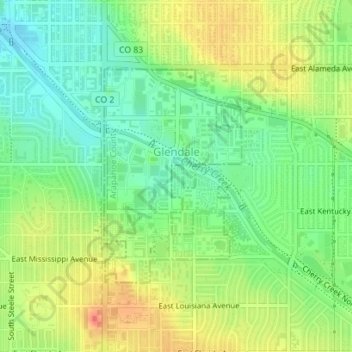
Name: Glendale topographic map, elevation, terrain.
Location: Glendale, Arapahoe County, Colorado, 80246, United States (39.69475 -104.94075 39.71111 -104.92700)
Average elevation: 5,390 ft
Minimum elevation: 5,315 ft
Maximum elevation: 5,479 ft
Arapahoe County trails, hiking, mountain biking, running and outdoor activities
Other topographic maps
Click on a map to view its topography, its elevation and its terrain.
Blackrock Lake
United States > Colorado > Arapahoe County > Littleton > Wolhurst
Average elevation: 5,410 ft
Arapahoe County Fairgrounds and Regional Park
United States > Colorado > Arapahoe County > Aurora
Average elevation: 5,850 ft
Littleton
United States > Colorado > Arapahoe County > Littleton > Littleton
Littleton is located at 39°35′59″N 105°0′39″W / 39.59972°N 105.01083°W / 39.59972; -105.01083 (39.599691, −105.010929) at an elevation of 5,351 feet (1,631 m). Located in central Colorado at the junction of U.S. Route 85 and Colorado State Highway 470, the city is 9 miles (14 km) south…
Average elevation: 5,433 ft
Cherry Creek State Park
United States > Colorado > Arapahoe County > Greenwood Village
Average elevation: 5,620 ft
Greenwood Village
United States > Colorado > Arapahoe County > Greenwood Village > Greenwood Village
Average elevation: 5,525 ft