
Winter Hill topographic map
Interactive map
Click on the map to display elevation.
Winter Hill
Paths to the summit lead from Belmont (in Blackburn with Darwen), Rivington (in Chorley borough), and Horwich and Blackrod (in Bolton borough). The summit can also be reached via a short walk from the top of a road pass 1 1⁄4 miles (2 km) west of Belmont. The hill is a prominent feature on the skyline for most of the borough of Chorley and further afield. Winter Hill's topographic prominence results in it being classified as a Marilyn. The trig point on its summit marks the highest point in Blackburn with Darwen whereas the highest point in the Metropolitan Borough of Bolton is 440 yards (400 m) away on its south east slope at 1,467 feet (447 m) above sea level.
About this map
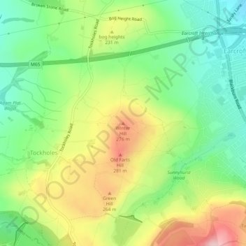
Name: Winter Hill topographic map, elevation, terrain.
Average elevation: 673 ft
Minimum elevation: 410 ft
Maximum elevation: 1,040 ft
Other topographic maps
Click on a map to view its topography, its elevation and its terrain.
River Severn
The River Severn (Welsh: Afon Hafren, pronounced [ˈavɔn ˈhavrɛn]), at 220 miles (354 km) long, is the longest river in Great Britain. It is also the river with the most voluminous flow of water by far in all of England and Wales, with an average flow rate of 107 m3/s (3,800 cu ft/s) at Apperley,…
Average elevation: 551 ft
Belthorn Reservoir (disused)
United Kingdom > England > Lancashire > Hyndburn > Oswaldtwistle
Average elevation: 955 ft
Gorilla Circus Regents Park Flying Trapeze School
United Kingdom > England > London > Camden Town
Average elevation: 135 ft
The Weald
Neither the thin infertile sands of the High Weald or the wet sticky clays of the Low Weald are suited to intensive arable farming and the topography of the area often increases the difficulties. There are limited areas of fertile greensand which can be used for intensive vegetable growing, as in the valley of…
Average elevation: 135 ft
Cooper's Lake
United Kingdom > England > Derbyshire > South Derbyshire > Weston-on-Trent
Average elevation: 154 ft
Burnley
United Kingdom > England > Lancashire
The town lies in a natural three-forked valley at the confluence of the River Brun and the River Calder, surrounded by open fields, with wild moorland at higher altitudes. To the west of Burnley lie the towns of Padiham, Accrington and Blackburn, with Nelson and Colne to the north. The centre of the town…
Average elevation: 810 ft
Hertfordshire
Elevations are higher in the north and west, reaching more than 800 feet (240 m) in the Chilterns near Tring. The county centres on the headwaters and upper valleys of the rivers Lea and the Colne; both flow south and each is accompanied by a canal. Hertfordshire's undeveloped land is mainly agricultural and…
Average elevation: 269 ft
Downham Market
United Kingdom > England > Norfolk > King's Lynn and West Norfolk
Average elevation: 66 ft
Lostock Gralam
United Kingdom > England > Cheshire West and Chester > Lostock Gralam
Average elevation: 108 ft
West Yorkshire
Wakefield's Parish Church was raised to cathedral status in 1888 and after the elevation of Wakefield to diocese, Wakefield Council immediately sought city status and this was granted in July 1888. However the Industrial Revolution, which changed West and South Yorkshire significantly, led to the growth of…
Average elevation: 564 ft
Cinderford
United Kingdom > England > Gloucestershire > Forest of Dean > Littledean
Average elevation: 568 ft