Geolocate

Harris County topographic map

Interactive map

Click on the map to display elevation.

About this map

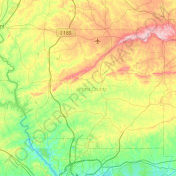
Name: Harris County topographic map, elevation, terrain.

Location: Harris County, Georgia, United States (32.58313 -85.18423 32.87249 -84.68288)

Average elevation: 669 ft

Minimum elevation: 315 ft

Maximum elevation: 1,358 ft

Georgia trails, hiking, mountain biking, running and outdoor activities

Other topographic maps

Click on a map to view its topography, its elevation and its terrain.

Athens

United States > Georgia > Athens

Average elevation: 725 ft

Augusta

United States > Georgia > Augusta

As with the rest of the state, Augusta has a humid subtropical climate (Köppen Cfa), with short, mild winters, very hot, humid summers, and a wide diurnal temperature variation throughout much of the year, despite its low elevation and moisture. The monthly daily average temperature ranges from 45.4 °F (7.4…

Average elevation: 295 ft

Atlanta

United States > Georgia > Fulton County

Atlanta (/ætˈlæntə/ at-LAN-tə) is the capital and most populous city of the U.S. state of Georgia. It is the seat of Fulton County, the most populous county in Georgia. With a population of 498,715 living within the city limits, it is the eighth most populous city in the Southeast and 38th most populous…

Average elevation: 935 ft

Whitehall

United States > Georgia > Clarke County > Athens

Average elevation: 673 ft

Skidaway Island

United States > Georgia > Chatham County

Average elevation: 10 ft

Stone Mountain

United States > Georgia > DeKalb County

The park is owned by the state of Georgia and is currently managed by Herschend Family Entertainment. At its summit, the elevation is 1,686 feet (514 m) above sea level and 825 feet (251 m) above the surrounding area. Stone Mountain is well known for not only its geology, but also the enormous rock relief on…

Average elevation: 981 ft

Vinings

United States > Georgia > Cobb County

Vinings features a varied topography characterized by rolling hills and lush, wooded areas that provide a picturesque backdrop to the community. The area is nestled alongside the Chattahoochee River, which contributes to the gentle slopes and valleys that define the landscape. Elevations in Vinings typically…

Average elevation: 922 ft

Gun Club Park

United States > Georgia > Fulton County > Atlanta

Average elevation: 883 ft

White City

United States > Georgia > Cherokee County

Average elevation: 1,152 ft

Missionary Ridge

United States > Georgia > Walker County

Average elevation: 1,106 ft

North Canton

United States > Georgia > Cherokee County > Canton

Average elevation: 958 ft

Rabun Gap

United States > Georgia > Rabun County

Average elevation: 2,241 ft

Rocky Face

United States > Georgia > Whitfield County

Average elevation: 912 ft

Marsh Creek

United States > Georgia > Gwinnett County

Average elevation: 1,024 ft

Ranger

United States > Georgia > Gordon County

Average elevation: 869 ft

Cartecay

United States > Georgia > Gilmer County

Average elevation: 1,657 ft

Trudie

United States > Georgia > Brantley County

Average elevation: 46 ft

Owltown

United States > Georgia > Union County

Average elevation: 2,224 ft

Alcovy Mountain

United States > Georgia > Walton County

Alcovy Mountain is a monadnock in the U.S. state of Georgia similar to Kennesaw Mountain in the city of Marietta. It is located in Walton County four miles south of the city of Monroe. With a summit elevation of 1,128 ft (344 m), the mountain is the highest point in Walton County, and is the southeastern-most…

Average elevation: 745 ft

Lax

United States > Georgia > Coffee County

Average elevation: 279 ft

Sea Island

United States > Georgia > Glynn County

Average elevation: 7 ft

Brasstown Bald

United States > Georgia > Towns County

Average elevation: 3,809 ft

Lands End

United States > Georgia > Camden County > St. Marys

Average elevation: 7 ft

Blood Mountain

United States > Georgia > Union County

Blood Mountain is the highest peak on the Georgia section of the Appalachian Trail and the sixth-tallest mountain in Georgia, with an elevation of 4,458 feet (1,359 m). It is located on the border of Lumpkin County with Union County and is within the boundaries of the Chattahoochee National Forest and the…

Average elevation: 3,438 ft

Mauk

United States > Georgia > Taylor County

Average elevation: 719 ft

Cutcane

United States > Georgia > Fannin County

Average elevation: 1,808 ft

Maul Hammock Prairie

United States > Georgia > Ware County

Average elevation: 121 ft

Meeks Park

United States > Georgia > Union County

Average elevation: 1,847 ft

Hopecastle Forest

United States > Georgia > Paulding County

Average elevation: 1,040 ft

Mount Herman

United States > Georgia > Chatham County > Savannah

Average elevation: 20 ft

Flintstone

United States > Georgia > Walker County

Average elevation: 846 ft

Doll Mountain

United States > Georgia > Gilmer County

Average elevation: 1,243 ft

Woodcraft

United States > Georgia > Meriwether County

Average elevation: 817 ft

Lake Lure Dam

United States > Georgia > Bacon County > Alma

Average elevation: 194 ft

Brook Run Park

United States > Georgia > DeKalb County > Dunwoody

Average elevation: 1,001 ft

Greenbrier

United States > Georgia > Richmond County > Augusta

Average elevation: 312 ft

Gaines Court

United States > Georgia > Richmond County > Augusta

Average elevation: 223 ft

Forsyth Park

United States > Georgia > Chatham County > Savannah

Average elevation: 39 ft

Rockingham

United States > Georgia > Bacon County

Average elevation: 184 ft

Batesville

United States > Georgia > Habersham County

Average elevation: 1,752 ft

Don Carter State Park

United States > Georgia > Hall County

Average elevation: 1,161 ft

Fleming

United States > Georgia > Liberty County

Average elevation: 16 ft

Jackson Lake

United States > Georgia > Brooks County

Average elevation: 184 ft

Hog Mountain

United States > Georgia > Gwinnett County

Average elevation: 1,106 ft

Pine Valley

United States > Georgia > Cook County

Average elevation: 220 ft

Pirkle Woods

United States > Georgia > Forsyth County > Cumming

Average elevation: 1,224 ft

Pembroke

United States > Georgia > Bryan County

Average elevation: 85 ft

Santaluca

United States > Georgia > Gilmer County

Average elevation: 1,663 ft

Ballew Mill

United States > Georgia > Fannin County

Average elevation: 1,827 ft

Jasper City Park

United States > Georgia > Pickens County > Jasper

Average elevation: 1,398 ft

Westwood

United States > Georgia > Dougherty County > Albany

Average elevation: 223 ft

Skidaway Island

United States > Georgia > Chatham County

Average elevation: 26 ft

Clem

United States > Georgia > Carroll County

Average elevation: 1,106 ft

Montgomery Lake

United States > Georgia > Telfair County

Average elevation: 131 ft

Dasher

United States > Georgia > Lowndes County

Average elevation: 167 ft

Sapelo Island

United States > Georgia > McIntosh County

Average elevation: 7 ft

Lake Rabun

United States > Georgia > Rabun County

Average elevation: 1,972 ft

Geneva

United States > Georgia > Talbot County

Average elevation: 538 ft

Argyle

United States > Georgia > Clinch County

Average elevation: 161 ft

Marshallville

United States > Georgia > Macon County

Average elevation: 479 ft

Hood Pond

United States > Georgia > White County > Leo

Average elevation: 1,417 ft

Iron City

United States > Georgia > Seminole County

Average elevation: 144 ft

Harlem

United States > Georgia > Columbia County

Average elevation: 486 ft

Newington

United States > Georgia > Screven County

Average elevation: 135 ft

Hickory Hills

United States > Georgia > Gwinnett County > Sugar Hill

Average elevation: 1,086 ft

De Soto

United States > Georgia > Sumter County

Average elevation: 308 ft

Nicholasville

United States > Georgia > Walton County

Average elevation: 879 ft

Georgetown

United States > Georgia > Quitman County

Average elevation: 243 ft

Du Pont

United States > Georgia > Clinch County

Average elevation: 180 ft

Rocky Ford

United States > Georgia > Screven County

Average elevation: 131 ft

Brinson

United States > Georgia > Decatur County

Average elevation: 118 ft

Cecil

United States > Georgia > Cook County

Average elevation: 226 ft

Bronwood

United States > Georgia > Terrell County

Average elevation: 358 ft

Oak Park

United States > Georgia > Emanuel County

Average elevation: 213 ft

Lenox

United States > Georgia > Cook County

Average elevation: 272 ft

Omega

United States > Georgia > Tift County

Average elevation: 312 ft

Cusseta

United States > Georgia > Chattahoochee County

Average elevation: 469 ft

Glynco

United States > Georgia > Glynn County > Brunswick

Average elevation: 26 ft

Omaha

United States > Georgia > Stewart County

Average elevation: 256 ft

Gaston Park

United States > Georgia > Whitfield County > Dalton

Average elevation: 751 ft

Walnut Mountain

United States > Georgia > Gilmer County

Average elevation: 1,896 ft

Windsor Forest

United States > Georgia > Richmond County > Augusta

Average elevation: 217 ft

Walnut Grove

United States > Georgia > Walker County

Average elevation: 823 ft

Foxlake

United States > Georgia > Bulloch County > Statesboro

Average elevation: 223 ft

Aska

United States > Georgia > Fannin County

Average elevation: 2,064 ft