
Bucks County topographic map
Interactive map
Click on the map to display elevation.
Bucks County
According to the Trewartha climate classification system, the Piedmont (United States) section of Bucks County, which is located roughly northwest of U.S. Route 1, has a Temperate Continental Climate with hot and slightly humid summers, cold winters and year-around precipitation (Dcao). Dcao climates are characterized by at least one month having an average mean temperature ≤ 32.0 °F (0 °C), four to seven months with an average mean temperature ≥ 50.0 °F (10 °C), at least one month with an average mean temperature ≥ 72.0 °F (22 °C) and no significant precipitation difference between seasons. According to the Köppen climate classification system, the climate is a hot-summer, wet all year, humid continental climate (Dfa). During the summer months in the Piedmont, episodes of extreme heat and humidity can occur with heat index values > 102 °F (39 °C). The average wettest month is July which corresponds with the annual peak in thunderstorm activity. During the winter months, episodes of extreme cold and wind can occur with wind chill values < −16 °F (−27 °C). The plant hardiness zone at Haycock Mountain, elevation 968 ft (295 m), is 6b with an average annual extreme minimum air temperature of −4.6 °F (−20 °C). The average seasonal (Nov-Apr) snowfall total is between 26 and 36 inches (66 and 91 cm) depending on elevation and distance from the Atlantic Ocean. The average snowiest month is February which correlates with the annual peak in nor'easter activity. Some areas of the Piedmont farther south and along the river below New Hope are in hardiness zone 7a, as is the Atlantic Coastal Plain region of Bucks.
About this map
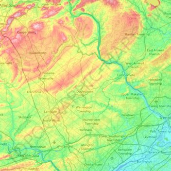
Name: Bucks County topographic map, elevation, terrain.
Location: Bucks County, Pennsylvania, United States (40.04980 -75.48393 40.60872 -74.72111)
Average elevation: 322 ft
Minimum elevation: -7 ft
Maximum elevation: 1,024 ft
Pennsylvania trails, hiking, mountain biking, running and outdoor activities
Other topographic maps
Click on a map to view its topography, its elevation and its terrain.
East Texas
United States > Pennsylvania > Lehigh County > Lower Macungie Township
Average elevation: 413 ft
Dingmans Ferry
United States > Pennsylvania > Pike County > Delaware Township
Average elevation: 630 ft
Hanover Junction
United States > Pennsylvania > York County > North Codorus Township
Average elevation: 614 ft
Fiddle Lake
United States > Pennsylvania > Susquehanna County > Ararat Township
Average elevation: 1,998 ft
Barronvale
United States > Pennsylvania > Somerset County > Middlecreek Township
Average elevation: 1,982 ft
Pocono Lake
United States > Pennsylvania > Monroe County > Tobyhanna Township
Average elevation: 1,781 ft
East York
United States > Pennsylvania > York County > Springettsbury Township
Average elevation: 469 ft
Hillside
United States > Pennsylvania > Lehigh County > South Whitehall Township
Average elevation: 499 ft
South Mountain
United States > Pennsylvania > Lehigh County > Upper Saucon
Unlike Blue Mountain to its north, South Mountain does not follow a straight geographic line. The mountain ranges in elevation between 500 and 1,300 feet (150 and 400 m) above sea level. The ridge is made of metamorphic rocks and gneiss, which date to the Precambrian era and range from about 570 million to…
Average elevation: 502 ft
Caledonia State Park
United States > Pennsylvania > Franklin County > Greene Township
Average elevation: 1,204 ft
Smithville
United States > Pennsylvania > Lancaster County > Providence Township
Average elevation: 459 ft
Griffin
United States > Pennsylvania > Fayette County > Nicholson Township
Average elevation: 1,040 ft
North Edinburg
United States > Pennsylvania > Lawrence County > Mahoning Township
Average elevation: 915 ft
Lake Carey
United States > Pennsylvania > Wyoming County > Lemon Township > Lemon > Lake Carey
Average elevation: 1,060 ft
Victory Hills
United States > Pennsylvania > Washington County > Carroll Township
Average elevation: 1,004 ft
Glen Summit
United States > Pennsylvania > Luzerne County > Fairview Township
Average elevation: 1,768 ft
Helen Furnace
United States > Pennsylvania > Clarion County > Highland Township
Average elevation: 1,447 ft
Zimmerman
United States > Pennsylvania > Somerset County > Somerset Township
Average elevation: 2,142 ft
Mount Nebo Park
United States > Pennsylvania > Monroe County > East Stroudsburg > Twin Falls
Average elevation: 607 ft
Elkdale
United States > Pennsylvania > Susquehanna County > Clifford Township
Average elevation: 1,519 ft
Monroe Heights
United States > Pennsylvania > Allegheny County > Monroeville
Average elevation: 1,083 ft
Allison Park
United States > Pennsylvania > Allegheny County > Hampton Township
Average elevation: 1,063 ft
Dalmatia
United States > Pennsylvania > Northumberland County > Lower Mahanoy Township
Average elevation: 564 ft
York Mountain
United States > Pennsylvania > Warren County > Brokenstraw Township
Average elevation: 1,640 ft
Reinholds
United States > Pennsylvania > Lancaster County > West Cocalico Township
Average elevation: 522 ft
South Strabane
United States > Pennsylvania > Washington County > South Strabane Township
Average elevation: 1,237 ft
Stevens
United States > Pennsylvania > Lancaster County > West Cocalico Township
Average elevation: 397 ft
Strawberry Mansion
United States > Pennsylvania > Philadelphia County > Philadelphia
Average elevation: 102 ft
Forest City Station
United States > Pennsylvania > Wayne County > Clinton Township
Average elevation: 1,742 ft
Langhorne Gardens
United States > Pennsylvania > Bucks County > Middletown Township
Average elevation: 148 ft
Chadds Ford Township
United States > Pennsylvania > Delaware County > Chadds Ford Township
Average elevation: 331 ft
Muncy Valley
United States > Pennsylvania > Sullivan County > Davidson Township
Average elevation: 1,240 ft
Morganville
United States > Pennsylvania > Montgomery County > Upper Moreland Township > Willow Grove
Average elevation: 266 ft
Elk Grove
United States > Pennsylvania > Columbia County > Sugarloaf Township
Average elevation: 1,752 ft
South Mountain
United States > Pennsylvania > Lehigh County > Upper Saucon
Unlike Blue Mountain to its north, South Mountain does not follow a straight geographic line. The mountain ranges in elevation between 500 and 1,300 feet (150 and 400 m) above sea level. The ridge is made of metamorphic rocks and gneiss, which date to the Precambrian era and range from about 570 million to…
Average elevation: 502 ft
Pleasureville
United States > Pennsylvania > York County > Springettsbury Township
Average elevation: 476 ft
Twin Lakes Park
United States > Pennsylvania > Westmoreland County > Hempfield Township > Luxor > Georges Station
Average elevation: 1,204 ft
Linden
United States > Pennsylvania > Washington County > North Strabane Township
Average elevation: 1,086 ft
Lakeside
United States > Pennsylvania > Susquehanna County > New Milford Township
Average elevation: 1,568 ft
Irving
United States > Pennsylvania > Schuylkill County > Pine Grove Township
Average elevation: 653 ft
Circleville
United States > Pennsylvania > Westmoreland County > North Huntingdon Township
Average elevation: 1,093 ft
Baptism Creek Spring
United States > Pennsylvania > Chester County > North Coventry Township
Average elevation: 748 ft
Coopersville
United States > Pennsylvania > Lancaster County > Sadsbury Township
Average elevation: 600 ft
Observatory Hill
United States > Pennsylvania > Allegheny County > Pittsburgh
Average elevation: 1,047 ft
Baumgardner
United States > Pennsylvania > Lancaster County > Pequea Township
Average elevation: 413 ft
Woodhouse
United States > Pennsylvania > Susquehanna County > Dimock Township
Average elevation: 1,365 ft
11th and Pike Playground
United States > Pennsylvania > Berks County > Reading
Average elevation: 433 ft
Roaring Brook
United States > Pennsylvania > Luzerne County > Hunlock Township
Average elevation: 1,106 ft
Nottingham County Park
United States > Pennsylvania > Chester County > West Nottingham Township
Average elevation: 449 ft
Mount Zion
United States > Pennsylvania > Cumberland County > South Middleton Township
Average elevation: 587 ft
Marble Hall
United States > Pennsylvania > Montgomery County > Whitemarsh Township
Average elevation: 210 ft
Mustard
United States > Pennsylvania > Allegheny County > Elizabeth Township
Average elevation: 1,017 ft
Parkers Glen
United States > Pennsylvania > Pike County > Shohola Township
Average elevation: 1,007 ft
Allegheny River Lock and Dam No. 2
United States > Pennsylvania > Allegheny County > O'Hara Township
Average elevation: 879 ft
Longwood Gardens
United States > Pennsylvania > Chester County > East Marlborough Township
Average elevation: 410 ft
Franklinville
United States > Pennsylvania > Montgomery County > Whitpain Township
Average elevation: 308 ft
Williamsburg
United States > Pennsylvania > Armstrong County > East Franklin Township
Average elevation: 1,047 ft
Gladwyne
United States > Pennsylvania > Montgomery County > Lower Merion Township
Average elevation: 302 ft
Blue Mountain
United States > Pennsylvania > Schuylkill County > Washington Township
The ridge of Blue Mountain runs for 150 miles (240 km) through Pennsylvania, reaching an elevation of 2,270 feet (690 m) above sea level just north of the Pennsylvania Turnpike, near the borough of Newburg. Most of the ridgecrest, however, only reaches between 1,400 and 1,700 feet (430 and 520 m) in elevation.…
Average elevation: 741 ft
Stoneybrooke Woods
United States > Pennsylvania > Allegheny County > Cheswick
Average elevation: 928 ft
Blue Ridge
United States > Pennsylvania > Bucks County > Bristol Township > Levittown
Average elevation: 52 ft
Highland Park Reservoir No. 2
United States > Pennsylvania > Allegheny County > Pittsburgh
Average elevation: 902 ft
Buttonwood
United States > Pennsylvania > Lycoming County > Jackson Township
Average elevation: 1,788 ft
Stevens Point
United States > Pennsylvania > Susquehanna County > Harmony Township
Average elevation: 1,424 ft
Southampton
United States > Pennsylvania > Bucks County > Upper Southampton Township
Average elevation: 246 ft
Ashmead Village
United States > Pennsylvania > Montgomery County > Cheltenham Township > Cheltenham
Average elevation: 167 ft
Madisonville
United States > Pennsylvania > Lackawanna County > Madison Township
Average elevation: 1,680 ft