
Laurentides topographic map
Interactive map
Click on the map to display elevation.
About this map
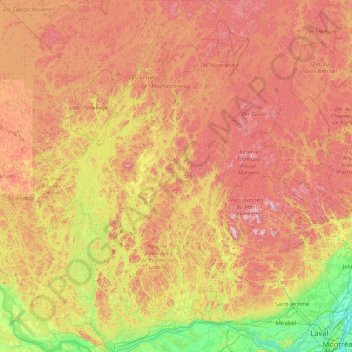
Name: Laurentides topographic map, elevation, terrain.
Location: Laurentides, Quebec, Canada (45.44990 -76.14926 47.76458 -73.73015)
Average elevation: 1,096 ft
Minimum elevation: 10 ft
Maximum elevation: 2,900 ft
Other topographic maps
Click on a map to view its topography, its elevation and its terrain.
Mount Royal
Canada > Quebec > Urban agglomeration of Montreal > Montreal
The hill is part of the Monteregian Hills situated between the Laurentians and the Appalachian Mountains. It gave its Latin name, Mons Regius, to the Monteregian chain. The hill consists of three peaks: Colline de la Croix (or Mont Royal proper) at 233 m (764 ft), Colline d'Outremont (or Mount Murray, in the…
Average elevation: 364 ft
Lac Parles-en-Pas
Canada > Quebec > La Vallée-de-l'Or > Senneterre (ville)
Average elevation: 1,713 ft
Saint Helen's Island
Canada > Quebec > Urban agglomeration of Montreal > Montreal
Average elevation: 49 ft
Tête-à-la-Baleine
Canada > Quebec > Le Golfe-du-Saint-Laurent > Côte-Nord-du-Golfe-du-Saint-Laurent
Average elevation: 79 ft
Magdalen Islands
Canada > Quebec > Urban agglomeration of Les Îles-de-la-Madeleine
Average elevation: 3 ft
Baie-Rouge
Canada > Quebec > Le Golfe-du-Saint-Laurent > Gros-Mécatina > La Tabatière
Average elevation: 39 ft
Mont Raoul-Blanchard
Canada > Quebec > La Côte-de-Beaupré > Lac-Jacques-Cartier
Average elevation: 3,222 ft
Labrador Peninsula
Canada > Quebec > Kativik > Rivière-Koksoak > Caniapiscau
Average elevation: 1,903 ft
Mont Victor-Tremblay
Canada > Quebec > Le Fjord-du-Saguenay > Saint-David-de-Falardeau
Average elevation: 2,054 ft
Parc Léon-Provancher
Canada > Quebec > Urban agglomeration of Montreal > Montreal
Average elevation: 174 ft
Saint-Michel-de-Wentworth
Canada > Quebec > Les Pays-d'en-Haut > Wentworth-Nord
Average elevation: 1,050 ft
Havre-aux-Maisons
Canada > Quebec > Urban agglomeration of Les Îles-de-la-Madeleine > Les Îles-de-la-Madeleine
Average elevation: 49 ft
Labrador Peninsula
Canada > Quebec > Kativik > Rivière-Koksoak > Caniapiscau
Average elevation: 1,903 ft
Colline de l'Abri
Canada > Quebec > Urban agglomeration of Montreal > Montreal
Average elevation: 394 ft
Gault Nature Reserve
Canada > Quebec > La Vallée-du-Richelieu > Mont-Saint-Hilaire
Average elevation: 620 ft
Rivière-la-Madeleine
Canada > Quebec > La Haute-Gaspésie > Sainte-Madeleine-de-la-Rivière-Madeleine
Average elevation: 151 ft
Lac du Bois Franc
Canada > Quebec > Témiscamingue > Les Lacs-du-Témiscamingue
Average elevation: 1,306 ft
Scouts Canada - Lake Lovering Scouts Reserve
Canada > Quebec > Memphrémagog > Magog
Average elevation: 853 ft
Madeleine-Centre
Canada > Quebec > La Haute-Gaspésie > Sainte-Madeleine-de-la-Rivière-Madeleine
Average elevation: 236 ft
Labrador Peninsula
Canada > Quebec > Kativik > Rivière-Koksoak > Caniapiscau
Average elevation: 1,903 ft
Saint-Louis-de-Masham
Canada > Quebec > Les Collines-de-l'Outaouais > La Pêche
Average elevation: 610 ft
Lac de la Montagne Brûlée
Canada > Quebec > Urban agglomeration of La Tuque > Lac-Édouard
Average elevation: 1,434 ft
Lac d'Argent
Canada > Quebec > La Côte-de-Beaupré > Saint-Ferréol-les-Neiges
Average elevation: 1,165 ft
Saint-Marc-du-Lac-Long
Canada > Quebec > Témiscouata > Saint-Marc-du-Lac-Long
Average elevation: 846 ft