
Make a donation
Gear up for your next adventure:
As an Amazon Associate, this site earns from qualifying purchases at no extra cost to you.
Hudson Bay topographic map
Click on the map to display elevation.
Make a donation
Gear up for your next adventure:
As an Amazon Associate, this site earns from qualifying purchases at no extra cost to you.
Hudson Bay
From the large quantity of published geologic data that has been collected as the result of hydrocarbon exploration, academic research, and related geologic mapping, a detailed history of the Hudson Bay basin has been reconstructed. During the majority of the Cambrian Period, this basin did not exist. Rather, this part of the Canadian Shield area was still topographically high and emergent. It was only during the later part of the Cambrian that the rising sea level of the Sauk marine transgression slowly submerged it. During the Ordovician, this part of the Canadian Shield continued to be submerged by rising sea levels except for a brief middle Ordovician marine regression. Only starting in the Late Ordovician and continuing into the Silurian did the gradual regional subsidence of this part of the Canadian Shield form the Hudson Bay basin. The formation of this basin resulted in the accumulation of black bituminous oil shale and evaporite deposits within its centre, thick basin-margin limestone and dolomite, and the development of extensive reefs that ringed the basin margins that were tectonically uplifted as the basin subsided. During Middle Silurian times, subsidence ceased and this basin was uplifted. It generated an emergent arch, on which reefs grew, that divided the basin into eastern and western sub-basins. During the Devonian Period, this basin filled with terrestrial red beds that interfinger with marine limestone and dolomites. Before deposition was terminated by marine regression, Upper Devonian black bituminous shale accumulated in the south-east of the basin.
Make a donation
Gear up for your next adventure:
As an Amazon Associate, this site earns from qualifying purchases at no extra cost to you.
About this map
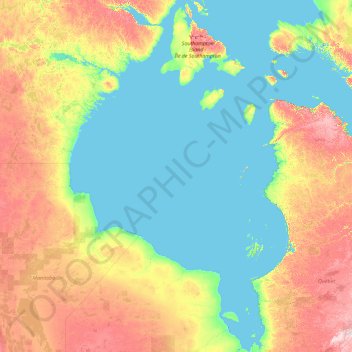
Name: Hudson Bay topographic map, elevation, terrain.
Location: Hudson Bay, Canada (54.63208 -94.85700 64.11375 -76.62038)
Average elevation: 115 ft
Minimum elevation: -3 ft
Maximum elevation: 1,138 ft
Make a donation
Gear up for your next adventure:
As an Amazon Associate, this site earns from qualifying purchases at no extra cost to you.
Other topographic maps
Click on a map to view its topography, its elevation and its terrain.
Toronto
Despite its deep ravines, Toronto is not remarkably hilly, but its elevation does increase steadily away from the lake. Elevation differences range from 76.5 metres (251 ft) above sea level at the Lake Ontario shore to 209 m (686 ft) ASL near the York University grounds in the city's north end at the…
Average elevation: 371 ft
Make a donation
Gear up for your next adventure:
As an Amazon Associate, this site earns from qualifying purchases at no extra cost to you.
Black Mountain (South Summit)
Canada > British Columbia > Metro Vancouver Regional District > West Vancouver
Average elevation: 3,071 ft
Mayor Island
Canada > British Columbia > Regional District of Mount Waddington > Area A (Seymour Inlet/Knight Inlet)
Average elevation: 16 ft
Make a donation
Gear up for your next adventure:
As an Amazon Associate, this site earns from qualifying purchases at no extra cost to you.
Medicine Lake
Canada > Alberta > Improvement District No. 12
Wildlife is surprisingly abundant along this high altitude lake. Grizzly bear, black bear, mule deer, caribou, wolves, moose and mountain sheep are some of the larger mammals that frequent the lake area during the summer season. Bald eagles, and osprey also frequent the area and live off the fish populations.
Average elevation: 5,515 ft
Slate Islands
Canada > Ontario > Kenora District > Unorganized Kenora District
Average elevation: 1,056 ft
Make a donation
Gear up for your next adventure:
As an Amazon Associate, this site earns from qualifying purchases at no extra cost to you.
Make a donation
Gear up for your next adventure:
As an Amazon Associate, this site earns from qualifying purchases at no extra cost to you.
El Capitan Mountain
Canada > British Columbia > Cowichan Valley Regional District > Area I (Youbou / Meade Creek)
Average elevation: 3,297 ft
Make a donation
Gear up for your next adventure:
As an Amazon Associate, this site earns from qualifying purchases at no extra cost to you.
Kootenay National Park
Canada > British Columbia > Regional District of East Kootenay
Kootenay National Park is a national park of Canada in southeastern British Columbia. The park consists of 1,406 km2 (543 sq mi) of the Canadian Rockies, including parts of the Kootenay and Park mountain ranges, the Kootenay River and the entirety of the Vermilion River. While the Vermilion River is completely…
Average elevation: 6,010 ft
Seymour Arm
Canada > British Columbia > Columbia-Shuswap Regional District > Area F (Scotch Creek/Seymour Arm)
Average elevation: 1,250 ft
Wimborne
Canada > Alberta > Kneehill County
Wimborne is a hamlet in southern Alberta, Canada within Kneehill County. It is located approximately 58 km (36 mi) southeast of Red Deer. It has an elevation of 975 m (3,199 ft).
Average elevation: 3,156 ft
Make a donation
Gear up for your next adventure:
As an Amazon Associate, this site earns from qualifying purchases at no extra cost to you.
Saint Andrews
Canada > New Brunswick > Charlotte County > Town of Saint Andrews
Average elevation: 23 ft
Dawsons Landing
Canada > British Columbia > Central Coast Regional District > Area A (Ocean Falls/Outer Coast)
Average elevation: 679 ft
Make a donation
Gear up for your next adventure:
As an Amazon Associate, this site earns from qualifying purchases at no extra cost to you.
Pinder Peak
Canada > British Columbia > Regional District of Mount Waddington > Area D (Nimpkish Valley/Cormorant Island)
Average elevation: 2,861 ft
Mount Hermann
Canada > British Columbia > Peace River Regional District > Tumbler Ridge
Average elevation: 4,721 ft
South Hazelton
Canada > British Columbia > Regional District of Kitimat-Stikine > Area B (Suskwa/Kitwanga/Kispiox)
Average elevation: 912 ft
Make a donation
Gear up for your next adventure:
As an Amazon Associate, this site earns from qualifying purchases at no extra cost to you.
Kendrick Point
Canada > British Columbia > North Coast Regional District > Area E (Moresby Island)
Average elevation: 131 ft
Eagle Mountain
Canada > British Columbia > Fraser Valley Regional District > Abbotsford
Average elevation: 420 ft
Manitouwadge
Canada > Ontario > Thunder Bay District > Manitouwadge Township
Average elevation: 1,184 ft
Make a donation
Gear up for your next adventure:
As an Amazon Associate, this site earns from qualifying purchases at no extra cost to you.
Make a donation
Gear up for your next adventure:
As an Amazon Associate, this site earns from qualifying purchases at no extra cost to you.
Steamboat
Canada > British Columbia > Northern Rockies Regional Municipality
Average elevation: 2,595 ft
Pittston
Canada > Ontario > Leeds and Grenville Counties > Edwardsburgh/Cardinal
Average elevation: 269 ft
Make a donation
Gear up for your next adventure:
As an Amazon Associate, this site earns from qualifying purchases at no extra cost to you.
Princton Heights Park
Canada > Nova Scotia > Municipality of Colchester > Salmon River
Average elevation: 194 ft
Mount Vernon
Canada > British Columbia > Cowichan Valley Regional District > Area F (Cowichan Lake South / Skutz Falls)
Average elevation: 2,041 ft
Make a donation
Gear up for your next adventure:
As an Amazon Associate, this site earns from qualifying purchases at no extra cost to you.
Carbon Peak
Canada > British Columbia > Peace River Regional District > Area E (Moberly Lake/Sukunka Valley)
Average elevation: 4,662 ft
Make a donation
Gear up for your next adventure:
As an Amazon Associate, this site earns from qualifying purchases at no extra cost to you.
Upper Fraser
Canada > British Columbia > Regional District of Fraser-Fort George > Area F (Willow River/Upper Fraser)
Average elevation: 2,123 ft
The Copilot
Canada > British Columbia > Squamish-Lillooet Regional District > Area D (Elaho/Garibaldi)
Average elevation: 4,816 ft
Make a donation
Gear up for your next adventure:
As an Amazon Associate, this site earns from qualifying purchases at no extra cost to you.
Make a donation
Gear up for your next adventure:
As an Amazon Associate, this site earns from qualifying purchases at no extra cost to you.
Cultus Lake
Canada > British Columbia > Fraser Valley Regional District > Area H (Cultus Lake/Columbia Valley) > Cultus Lake
Average elevation: 627 ft
Echo Lake
Canada > Ontario > Timiskaming District > Unorganized West Timiskaming
Average elevation: 1,112 ft
Make a donation
Gear up for your next adventure:
As an Amazon Associate, this site earns from qualifying purchases at no extra cost to you.
Kingsvale
Canada > British Columbia > Thompson-Nicola Regional District > Area N (Beautiful Nicola Valley - South)
Average elevation: 3,045 ft
Ellery Lake
Canada > Ontario > Cochrane District > Unorganized North Cochrane
Average elevation: 1,148 ft
Make a donation
Gear up for your next adventure:
As an Amazon Associate, this site earns from qualifying purchases at no extra cost to you.
Van Somer Point
Canada > British Columbia > Peace River Regional District > Area B (Finlay Valley/Beatton Valley)
Average elevation: 2,198 ft
Make a donation
Gear up for your next adventure:
As an Amazon Associate, this site earns from qualifying purchases at no extra cost to you.
Honeymoon Island
Canada > British Columbia > Regional District of Bulkley-Nechako > Area C (Stuart Lake/Omineca Valley)
Average elevation: 2,828 ft
Lushes Bight
Canada > Newfoundland and Labrador > Lushes Bight-Beaumont-Beaumont North
Average elevation: 82 ft
Make a donation
Gear up for your next adventure:
As an Amazon Associate, this site earns from qualifying purchases at no extra cost to you.
Make a donation
Gear up for your next adventure:
As an Amazon Associate, this site earns from qualifying purchases at no extra cost to you.
Sonora Park
Canada > British Columbia > Regional District of Central Okanagan > Kelowna
Average elevation: 1,371 ft
Make a donation
Gear up for your next adventure:
As an Amazon Associate, this site earns from qualifying purchases at no extra cost to you.
Morewood
Canada > Ontario > Stormont, Dundas and Glengarry Counties > North Dundas
Average elevation: 253 ft
Make a donation
Gear up for your next adventure:
As an Amazon Associate, this site earns from qualifying purchases at no extra cost to you.
Fauquier
Canada > Ontario > Cochrane District > Fauquier-Strickland Township
Average elevation: 738 ft
Banff
Canada > Alberta > Banff > Banff
Banff is a town within Banff National Park in Alberta, Canada. It is located in Alberta's Rockies along the Trans-Canada Highway, approximately 126 km (78 mi) west of Calgary and 58 km (36 mi) east of Lake Louise. At 1,400 to 1,630 m (4,590 to 5,350 ft) above sea level, Banff is the community with the second…
Average elevation: 5,299 ft
Make a donation
Gear up for your next adventure:
As an Amazon Associate, this site earns from qualifying purchases at no extra cost to you.
Sesekinika
Canada > Ontario > Timiskaming District > Unorganized West Timiskaming
Average elevation: 1,050 ft
Arden Islet
Canada > British Columbia > Capital Regional District > Juan de Fuca Electoral Area
Average elevation: 164 ft
Make a donation
Gear up for your next adventure:
As an Amazon Associate, this site earns from qualifying purchases at no extra cost to you.
Denarta Park
Canada > British Columbia > Regional District of Kitimat-Stikine > Area C (Butedale/Kitlope/Kitsumkalum)
Average elevation: 509 ft
Make a donation
Gear up for your next adventure:
As an Amazon Associate, this site earns from qualifying purchases at no extra cost to you.