
Burleigh County topographic map
Interactive map
Click on the map to display elevation.
About this map
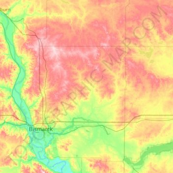
Name: Burleigh County topographic map, elevation, terrain.
Location: Burleigh County, North Dakota, United States (46.63163 -100.95960 47.32719 -100.07768)
Average elevation: 1,877 ft
Minimum elevation: 1,608 ft
Maximum elevation: 2,264 ft
North Dakota trails, hiking, mountain biking, running and outdoor activities
Other topographic maps
Click on a map to view its topography, its elevation and its terrain.
White Horse Hill National Game Preserve
United States > North Dakota > Benson County > Fort Totten
Average elevation: 1,545 ft
Arvilla
United States > North Dakota > Grand Forks County
Arvilla (also Orange) is an unincorporated community in central Grand Forks County, North Dakota, United States. It lies along U.S. Route 2, west of the city of Grand Forks, the county seat of Grand Forks County. Its elevation is 1,004 feet (306 m). The community was first named Orange for Orange County, New…
Average elevation: 1,010 ft
Mekinock
United States > North Dakota > Grand Forks County
Mekinock is an unincorporated community in eastern Grand Forks County, North Dakota, United States. It lies northwest of the city of Grand Forks, the county seat of Grand Forks County. Mekinock's elevation is 860 feet (262 m). It has a post office with the ZIP code 58258.
Average elevation: 860 ft
Grand Forks
United States > North Dakota > Grand Forks County > Grand Forks
Grand Forks is 74 miles (119 km) north of the Fargo-Moorhead area and 145 miles (233 km) south of Winnipeg, Manitoba. Grand Forks is on the western bank of the Red River of the North in an area known as the Red River Valley. The term "forks" refers to the forking of the Red River with the Red Lake River near…
Average elevation: 846 ft