
Roan Mountain topographic map
Interactive map
Click on the map to display elevation.
About this map
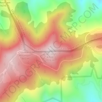
Name: Roan Mountain topographic map, elevation, terrain.
Location: Roan Mountain, Carter County, Tennessee, United States (36.10451 -82.12212 36.10461 -82.12202)
Average elevation: 5,420 ft
Minimum elevation: 4,383 ft
Maximum elevation: 6,247 ft
Tennessee trails, hiking, mountain biking, running and outdoor activities
Other topographic maps
Click on a map to view its topography, its elevation and its terrain.
Monteagle
United States > Tennessee > Grundy County
The town straddles a narrow stretch of the Cumberland Plateau known colloquially as "Monteagle Mountain". This stretch of the plateau is approximately 2 miles (3 km) wide, with steep drop-offs to the northwest and southeast. Monteagle lies at an elevation of just under 2,000 feet (610 m) above sea level. By…
Average elevation: 1,598 ft
Townsend
United States > Tennessee > Blount County
Just to the north and west of Townsend, the Foothills Parkway is a national parkway that traverses Chilhowee Mountain and offers multiple scenic overlooks at high elevations, with views of the Smokies to the south and the Tennessee Valley and Cumberland Plateau to the north and west. As of 2016, road…
Average elevation: 1,234 ft
McMinnville
United States > Tennessee > Warren County
According to the United States Census Bureau, the city has a total area of 10.0 square miles (26 km2), all land. McMinnville lies at an elevation of 968 feet (295 m), as it sits along the Eastern Highland Rim near the base of the Cumberland Plateau. The city is drained primarily by the Barren Fork, a tributary…
Average elevation: 991 ft
Greene County
According to the U.S. Census Bureau, the county has a total area of 624 square miles (1,620 km2), of which 622 square miles (1,610 km2) is land and 2.0 square miles (5.2 km2) (0.3%) is water. Most of Greene County is located within the Ridge-and-Valley Appalachians, a range characterized by long, narrow ridges…
Average elevation: 1,611 ft
West Tennessee
West Tennessee is located almost entirely within the Mississippi Embayment, part of the Gulf Coastal Plain. Because of this, the terrain is flatter than the eastern parts of the state. Areas along the Mississippi River are located within the Mississippi Alluvial Plain, which is primarily a floodplain with many…
Average elevation: 417 ft
Tennesse Riverwalk
United States > Tennessee > Hamilton County > Chattanooga
Average elevation: 679 ft
Bays Mountain
United States > Tennessee > Hawkins County
The southern segment of Bays Mountain is relatively low in elevation (up to about 1,300 feet (396.2 m)). In some places it essentially merges with the surrounding plains, especially where it is bisected by the French Broad River and the Nolichucky River. The northern segment of Bays Mountain reaches higher…
Average elevation: 1,375 ft
Douglas Dam
United States > Tennessee > Sevier County
The Douglas Project required the construction of ten smaller, earthen saddle dams to fill in gaps along the adjacent ridgeline and permit a higher water elevation than would otherwise be possible. Most of these saddle dams are located in the hills southeast of the main dam. One protects downtown Dandridge,…
Average elevation: 1,024 ft
Sevier Park
United States > Tennessee > Davidson County > Nashville-Davidson
Average elevation: 568 ft
Raccoon Mountain Pumped Station Dam
United States > Tennessee > Marion County > Chattanooga
Average elevation: 1,362 ft
Big Ridge State Park
United States > Tennessee > Union County
Big Ridge State Park is located in the Appalachian Ridge-and-Valley range, which is characterized by narrow elongate ridges flanked by fertile stream valleys. The park's topography is dominated by three such ridge systems running roughly parallel to one another, the two northernmost of which are bisected by…
Average elevation: 1,155 ft
Lake Tullahoma
United States > Tennessee > Coffee County > Tullahoma > Lake Tullahoma Estates
Average elevation: 1,056 ft
Old Hickory Lake
United States > Tennessee > Wilson County > Mount Juliet
Old Hickory Lake is a mainstream storage impoundment on the Cumberland River operated by the U.S. Army Corps of Engineers. The reservoir contains 22,500 acres (91 km2) at an elevation of 445 feet (above sea level) and extends 97.3 river miles. Water level fluctuations are minimal with minimum pool elevation at…
Average elevation: 561 ft
Tennessee Ridge
United States > Tennessee > Houston County
Tennessee Ridge is located at 36°19′15″N 87°45′47″W / 36.32083°N 87.76306°W / 36.32083; -87.76306 (36.320797, -87.763012), at an elevation of 742 feet above sea level.
Average elevation: 669 ft
Roan Mountain State Park
United States > Tennessee > Carter County > Roan Mountain
Roan Mountain State Park hosts a variety of outdoor activities including hiking, mountain biking, camping, cross-country skiing (during snowy, winter months), fishing, and swimming. A heated swimming pool is open from Memorial Day to mid-August. At an elevation of 2,972 feet (906 m), the outdoor swimming pool…
Average elevation: 3,241 ft
Chickamauga Lake
United States > Tennessee > Hamilton County > Soddy-Daisy
Average elevation: 1,099 ft
Henry Horton State Park
United States > Tennessee > Marshall County > Chapel Hill
Average elevation: 679 ft
Fort Loudoun
United States > Tennessee > Monroe County > Vonore > Fort Loudon
Average elevation: 846 ft
South Pittsburg
United States > Tennessee > Marion County
South Pittsburg is located at 35°0′30″N 85°42′38″W / 35.00833°N 85.71056°W / 35.00833; -85.71056 (35.008342, -85.710645). The city is situated in the southwestern Sequatchie Valley between the Cumberland Plateau on the west and the Tennessee River (Guntersville Lake) on the east. Two steep…
Average elevation: 892 ft
Lockeland Springs Park
United States > Tennessee > Davidson County > Nashville-Davidson
Average elevation: 489 ft