
Sea of Galilee topographic map
Interactive map
Click on the map to display elevation.
Sea of Galilee
After five years of drought as of 2018, Sea of Galilee is expected to get to the black line. The black elevation line is the lowest depth from which irreversible damage begins and no water can be pumped out any more. Israel Oceanographic and Limnological Research describes it as "The black line marks −214.87 m, the lowest-ever level reached since 1926 when the water level record began. According to the water authority, the Kinneret water level must not decline below this level."
About this map
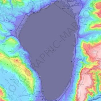
Name: Sea of Galilee topographic map, elevation, terrain.
Location: Sea of Galilee, Kinneret Subdistrict, North District, Israel (32.70551 35.51622 32.89644 35.64978)
Average elevation: -220 ft
Minimum elevation: -719 ft
Maximum elevation: 1,211 ft
Other topographic maps
Click on a map to view its topography, its elevation and its terrain.
Golan Heights
Israel > North District > Golan Regional Council
The Golan Heights is a basaltic plateau in southwestern Syria, extending about 44 miles (71 km) from north to south and about 27 miles (43 km) from east to west at its widest point, covering approximately 444 square miles (1,150 square km). The terrain is characterized by its hilly and elevated nature, with an…
Average elevation: 1,749 ft
Karmiel
Karmiel is located on the Acre–Safed road, on the northern edge of the Lower Galilee. It lies in the Beit HaKerem Valley and its elevation is 330 m (1,082.68 ft). The Hilazon Stream passes slightly to the south of Karmiel. Its tributaries, the Shezor and Shagor Streams pass through Karmiel on the east and…
Average elevation: 791 ft
2236 Mt. Hermon
Israel > North District > Golan Regional Council
Mount Hermon (Arabic: جبل الشيخ or جبل حرمون / ALA-LC: Jabal al-Shaykh ('Mountain of the Sheikh') or Jabal Haramun; Hebrew: הַר חֶרְמוֹן, Har Ḥermōn) is a mountain cluster constituting the southern end of the Anti-Lebanon mountain range. Its summit straddles the border between…
Average elevation: 6,614 ft
Nazareth
Israel > North District > Nazareth
As of the early 1990s, no city plans drafted by Nazareth Municipality have been approved by the government (both the British Mandate and later Israel) since 1942. This has left many people in Nazareth who vote in the city's municipal elections and receive services from its municipality effectively outside of…
Average elevation: 495 ft
Nazareth
Israel > North District > Nazareth
As of the early 1990s, no city plans drafted by Nazareth Municipality have been approved by the government (both the British Mandate and later Israel) since 1942. This has left many people in Nazareth who vote in the city's municipal elections and receive services from its municipality effectively outside of…
Average elevation: 1,178 ft
Mishmar HaEmek
Israel > North District > Megido Regional Council > Mishmar HaEmek
Average elevation: 410 ft
Deganya Alef
Israel > North District > Emek HaYarden Regional Council > Deganya Alef
Average elevation: -659 ft
Tiberias
Tiberias is located on the shore of the Sea of Galilee and the western slopes of the Jordan Rift Valley overlooking the lake, in the elevation range of −200 to 200 metres (−660–660 feet). Tiberias has a climate that borders a Hot-summer Mediterranean climate (koppen Csa) and a Hot Semi-arid climate…
Average elevation: -7 ft