
Wise County topographic map
Click on the map to display elevation.
Wise County
Wise County lies in north-central Texas where the Grand Prairie and Western Cross Timbers meet, giving the county a varied but generally low-relief upland character. Its surface is a mix of flat to gently undulating central terrain and more broken, hilly country toward the west, with clayey soils, limestone and sandy layers shaping a landscape of prairies, oak woodlands, grazing land, and farmland. The county stands at an average elevation of about 800 feet (244 m), with local high ground rising above 1,200 feet (366 m) in the west and lower drainage corridors descending eastward toward Denton County and the Trinity River system. Much of the land is drained by the West Fork of the Trinity River, while creeks and reservoirs such as Lake Bridgeport occupy broader valleys, softening the plateau-like surface with shallow basins and stream-cut relief. Overall, Wise County presents a transitional North Texas topography: open prairie surfaces, wooded Cross Timbers ridges, rolling divides, and modest but noticeable elevation gradients from the higher western uplands toward the lower eastern plains.
About this map
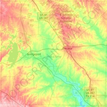
Name: Wise County topographic map, elevation, terrain.
Location: Wise County, Texas, United States (32.99168 -97.92153 33.43394 -97.38295)
Average elevation: 892 ft
Minimum elevation: 643 ft
Maximum elevation: 1,260 ft
Texas trails, hiking, mountain biking, running and outdoor activities
Other topographic maps
Click on a map to view its topography, its elevation and its terrain.
Georgetown
United States > Texas > Georgetown
The city is located on the northeastern edge of Texas Hill Country. Portions of Georgetown are located on either side of the Balcones Escarpment, a fault line in which the areas roughly east of IH-35 are flat and characterized by having black, fertile soils of the Blackland Prairie, and the west side of the…
Average elevation: 719 ft
Inks Lake State Park
United States > Texas > Burnet County > Burnet
Conservation Pool Elevation usually stays around 888.22 ft. msl; however, this lake does fluctuate about 1 foot annually. Inks lake water clarity can be seen as clear to slightly stained mostly throughout the year. It tends to have higher turbidity during the rainy season due to excessive amounts of runoff.
Average elevation: 965 ft
Roosevelt
United States > Texas > Lubbock County
Roosevelt is an unincorporated community in Lubbock County, Texas, United States. It sits at an elevation of 3136 feet (956 m). The community is part of the Lubbock Metropolitan Statistical Area. It mainly consists of Roosevelt High school. There is also a Baptist church here.
Average elevation: 3,140 ft
Enchanted Rock
United States > Texas > Llano County
Enchanted Rock is a pink granite mountain located in the Llano Uplift about 17 miles (27 km) north of Fredericksburg, Texas and 24 miles (39 km) south of Llano, Texas, United States. Enchanted Rock State Natural Area, which includes Enchanted Rock and surrounding land, spans the border between Gillespie and…
Average elevation: 1,486 ft
Padre Island National Seashore
United States > Texas > Kenedy County > Corpus Christi
Average elevation: 16 ft
Choke Canyon State Park - Calliham Unit
United States > Texas > McMullen County > Calliham
Average elevation: 220 ft