
Cypress Lake topographic map
Interactive map
Click on the map to display elevation.
About this map
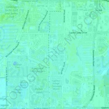
Name: Cypress Lake topographic map, elevation, terrain.
Location: Cypress Lake, Lee County, Florida, 33919, United States (26.52033 -81.91874 26.55692 -81.88512)
Average elevation: 13 ft
Minimum elevation: 0 ft
Maximum elevation: 30 ft
Lee County trails, hiking, mountain biking, running and outdoor activities
Other topographic maps
Click on a map to view its topography, its elevation and its terrain.
Spring Creek Village
United States > Florida > Lee County > Bonita Springs > Pelican Landing
Average elevation: 13 ft
Riverbend Golf and River Club
United States > Florida > Lee County > North Fort Myers
Average elevation: 10 ft
Bonita National Golf & Country Club
United States > Florida > Lee County > Bonita Springs
Average elevation: 16 ft
Highland Woods Golf & Country Club
United States > Florida > Lee County > Bonita Springs
Average elevation: 16 ft
Palm Frond Condominiums
United States > Florida > Lee County > North Fort Myers
Average elevation: 10 ft
Habitat for Humanity Housing
United States > Florida > Lee County > North Fort Myers
Average elevation: 10 ft
Coconut Shores
United States > Florida > Lee County > The Colony Golf & Bay Club
Average elevation: 20 ft
Carmel at Vanderbilt Lakes
United States > Florida > Lee County > Bonita Springs
Average elevation: 16 ft
Swan Lake Travel Trailer Park
United States > Florida > Lee County > North Fort Myers
Average elevation: 20 ft
Worthington Country Club
United States > Florida > Lee County > Bonita Springs
Average elevation: 20 ft
Shangri-La Mobile Home Park
United States > Florida > Lee County > Saint James City
Average elevation: 3 ft
Caloosahatchee River
United States > Florida > Lee County
Until late in the 19th century, the Caloosahatchee River was fed by a series of lakes starting from Lake Hicpochee, and including Lettuce Lake, Bonnet Lake and Flirt Lake. A waterfall and set of rapids at the lower end of Flirt Lake marked the beginning of the river. The rapids were close to 1 mile (1.6 km)…
Average elevation: 26 ft
Herons Glen Golf and Country Club
United States > Florida > Lee County > Herons Glen Golf and Country Club
Average elevation: 26 ft
Saint James Mobile Home Park
United States > Florida > Lee County > Saint James City
Average elevation: 3 ft
Calusa Land Trust and Nature Preserve of Pine Island
United States > Florida > Lee County > Cape Coral
Average elevation: 3 ft
Caloosa Mobile Home Village
United States > Florida > Lee County > North Fort Myers
Average elevation: 7 ft
Six Lakes Country Club
United States > Florida > Lee County > North Fort Myers > Six Lakes Country Club
Average elevation: 16 ft
Residences at Coconut Point
United States > Florida > Lee County > Shadow Wood
Average elevation: 20 ft
Pioneer Village RV Resort & Resort Community
United States > Florida > Lee County > North Fort Myers
Average elevation: 13 ft
Rapallo at Coconut Point
United States > Florida > Lee County > Shadow Wood > Rapallo at Coconut Point
Average elevation: 20 ft
Estero Bay Preserve State Park
United States > Florida > Lee County > Fort Myers Beach
Average elevation: 7 ft