
Make a donation
Gear up for your next adventure:
As an Amazon Associate, this site earns from qualifying purchases at no extra cost to you.
Sicily topographic map
Click on the map to display elevation.
Make a donation
Gear up for your next adventure:
As an Amazon Associate, this site earns from qualifying purchases at no extra cost to you.
Sicily
According to the Regional Agency for Waste and Water, on 10 August 1999, the weather station of Catenanuova (EN) recorded a maximum temperature of 48.5 °C (119 °F). The official European record – measured by minimum/maximum thermometers – is held by Athens, Greece, which reported a maximum of 48.0 °C (118 °F) in 1977. Total precipitation is highly variable, generally increasing with elevation. In general, the southern and southeast coast receives the least rainfall (less than 50 cm (20 in)), and the northern and northeastern highlands the most (over 100 cm (39 in)).
Make a donation
Gear up for your next adventure:
As an Amazon Associate, this site earns from qualifying purchases at no extra cost to you.
About this map
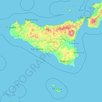
Name: Sicily topographic map, elevation, terrain.
Location: Sicily, Italy (35.49295 11.92586 38.81766 15.65308)
Average elevation: 305 ft
Minimum elevation: -3 ft
Maximum elevation: 10,558 ft
Make a donation
Gear up for your next adventure:
As an Amazon Associate, this site earns from qualifying purchases at no extra cost to you.
Other topographic maps
Click on a map to view its topography, its elevation and its terrain.
Matterhorn
Italy > Aosta Valley > Valtournenche
In 1999, the summit height was precisely determined to be at 4,477.54 m (14,690 ft) above sea level by using Global Positioning System technology as part of the TOWER Project (Top of the World Elevations Remeasurement) and to an accuracy of less than one centimetre, which allows future changes to be tracked.
Average elevation: 10,810 ft
Tai di Cadore
Italy > Veneto > Belluno > Pieve di Cadore > Pieve di Cadore
Average elevation: 3,074 ft
Le Breuil - Cervinia
The ski area is very large and guarantees good snow quality during the season, being at a high altitude (2,050 m to 3,500 m).
Average elevation: 7,795 ft
Make a donation
Gear up for your next adventure:
As an Amazon Associate, this site earns from qualifying purchases at no extra cost to you.
Mount Vesuvius
Italy > Campania > Naples > Trecase
The volcano's slopes are scarred by lava flows, while the rest are heavily vegetated, with scrub and forests at higher altitudes and vineyards lower down.
Average elevation: 2,828 ft
Mount Etna
During the first 1500 years AD, many eruptions went unrecorded (or records have been lost); among the more significant are: (1) an eruption in about 1030 AD near Monte Ilice on the lower southeast flank, which produced a lava flow that travelled about 10 km, reaching the sea north of Acireale; the villages of…
Average elevation: 3,796 ft
San Martino / San Martin
Italy > Friuli – Venezia Giulia > Pordenone / Pordenon > Erto e Casso / Nert e Cjas > Erto / Nert
Average elevation: 3,593 ft
Make a donation
Gear up for your next adventure:
As an Amazon Associate, this site earns from qualifying purchases at no extra cost to you.
Monte Cassino
Italy > Lazio > Frosinone > Cassino
Monte Cassino (today usually spelled Montecassino) is a rocky hill about 130 kilometres (80 mi) southeast of Rome, in the Latin Valley, Italy, 2 kilometres (1+1⁄4 mi) west of Cassino and at an elevation of 520 m (1,710 ft). Site of the Roman town of Casinum, it is widely known for its abbey, the first house…
Average elevation: 758 ft
Make a donation
Gear up for your next adventure:
As an Amazon Associate, this site earns from qualifying purchases at no extra cost to you.
Semonzo del Grappa
Italy > Veneto > Province of Treviso > Borso del Grappa
Average elevation: 1,119 ft
Naples
Italy > Campania > Napoli > Naples
The city is situated on the Gulf of Naples, on the western coast of southern Italy; it rises from sea level to an elevation of 450 metres (1,480 ft). The small rivers which formerly crossed the centre of the city have since been covered over by construction. It lies between two notable volcanic regions, Mount…
Average elevation: 190 ft
Make a donation
Gear up for your next adventure:
As an Amazon Associate, this site earns from qualifying purchases at no extra cost to you.
Rome
Italy > Lazio > Roma Capitale
Although the city centre is about 24 km (15 mi) inland from the Tyrrhenian Sea, the city territory extends to the shore, where the south-western district of Ostia is located. The altitude of the central part of Rome ranges from 13 m (43 ft) above sea level (at the base of the Pantheon) to 139 m (456 ft) above…
Average elevation: 256 ft
Apennine Mountains
A separate branch, the Apuan Alps, goes southwest, bordering the coast south of La Spezia. Whether they are to be considered part of the Apennines is a matter of opinion; certainly, they are part of the Apennine System. Topographically only the valley of the River Serchio, which running parallel to the coast…
Average elevation: 5,692 ft
Castelletta I
Italy > Marche > Macerata > Civitanova Marche > Civitanova Alta
Average elevation: 135 ft
Make a donation
Gear up for your next adventure:
As an Amazon Associate, this site earns from qualifying purchases at no extra cost to you.
Rentsch - Rencio
Italy > Trentino – Alto Adige/Südtirol > South Tyrol > Bolzano
Average elevation: 1,808 ft
Etna
Italy > Sicily > Catania > Zafferana Etnea
Eruptions of Etna follow multiple patterns. Most occur at the summit, where there are five distinct craters: the Northeast Crater, the Voragine, the Bocca Nuova, and two at the Southeast Crater Complex. Other eruptions occur on the flanks, which have more than 300 vents ranging in size from small holes in the…
Average elevation: 9,764 ft
Make a donation
Gear up for your next adventure:
As an Amazon Associate, this site earns from qualifying purchases at no extra cost to you.
Make a donation
Gear up for your next adventure:
As an Amazon Associate, this site earns from qualifying purchases at no extra cost to you.
Cascina Norbiato
Italy > Veneto > Province of Padua > Villafranca Padovana > Taggì di Sotto
Average elevation: 56 ft
Make a donation
Gear up for your next adventure:
As an Amazon Associate, this site earns from qualifying purchases at no extra cost to you.
Trafoi
Italy > Trentino – Alto Adige/Südtirol > South Tyrol > Stilfs - Stelvio
Average elevation: 6,719 ft
Make a donation
Gear up for your next adventure:
As an Amazon Associate, this site earns from qualifying purchases at no extra cost to you.
Make a donation
Gear up for your next adventure:
As an Amazon Associate, this site earns from qualifying purchases at no extra cost to you.
Masdone
Italy > Emilia-Romagna > Parma > Lesignano de' Bagni > Lesignano de' Bagni
Average elevation: 827 ft
Make a donation
Gear up for your next adventure:
As an Amazon Associate, this site earns from qualifying purchases at no extra cost to you.
Make a donation
Gear up for your next adventure:
As an Amazon Associate, this site earns from qualifying purchases at no extra cost to you.
Treppo Carnico / Trep di Cjargne
Italy > Friuli – Venezia Giulia > Udine / Udin / Videm > Treppo Ligosullo / Trep Liussûl
Average elevation: 3,196 ft
Make a donation
Gear up for your next adventure:
As an Amazon Associate, this site earns from qualifying purchases at no extra cost to you.
Coll - Colle
Italy > Trentino – Alto Adige/Südtirol > South Tyrol > St. Magdalena - Santa Maddalena
Average elevation: 4,590 ft
Make a donation
Gear up for your next adventure:
As an Amazon Associate, this site earns from qualifying purchases at no extra cost to you.
Make a donation
Gear up for your next adventure:
As an Amazon Associate, this site earns from qualifying purchases at no extra cost to you.
Mottarone
Italy > Piedmont > Verbano-Cusio-Ossola > Stresa
Mottarone is a mountain in the Western Alps of Piedmont, north-western Italy, with an elevation of 1,492 metres (4,895 ft). It is located between the provinces of Verbano-Cusio-Ossola and Novara.
Average elevation: 3,862 ft
Make a donation
Gear up for your next adventure:
As an Amazon Associate, this site earns from qualifying purchases at no extra cost to you.
Gsieser Tal - Valle di Casies
Italy > Trentino – Alto Adige/Südtirol > South Tyrol > Gsies - Valle di Casies
Average elevation: 6,463 ft
Make a donation
Gear up for your next adventure:
As an Amazon Associate, this site earns from qualifying purchases at no extra cost to you.
Make a donation
Gear up for your next adventure:
As an Amazon Associate, this site earns from qualifying purchases at no extra cost to you.
Make a donation
Gear up for your next adventure:
As an Amazon Associate, this site earns from qualifying purchases at no extra cost to you.
Make a donation
Gear up for your next adventure:
As an Amazon Associate, this site earns from qualifying purchases at no extra cost to you.
Monviso
Italy > Piedmont > Cuneo > Pontechianale
Monte Viso is the location of a neolithic jadeite quarry, at an elevation of 2000 to 2400 metres. Its productivity peaked around 5000 BC. The jadeite was used to make cult axes, which are found all over western Europe. One such ceremonial axe head was found as far away as a small hill called Tristia in Western…
Average elevation: 9,793 ft
Make a donation
Gear up for your next adventure:
As an Amazon Associate, this site earns from qualifying purchases at no extra cost to you.
Make a donation
Gear up for your next adventure:
As an Amazon Associate, this site earns from qualifying purchases at no extra cost to you.
Gran Paradiso
Italy > Aosta Valley > Valsavarenche
The peak is the 7th highest mountain in the Graian Alps, with an elevation of 4,061 m. In the SOIUSA (International Standardized Mountain Subdivision of the Alps) the mountain belongs to an alpine subsection called "North-Eastern Graian Alps" (It:Alpi del Gran Paradiso; Fr:Alpes du Grand-Paradis) and also…
Average elevation: 11,348 ft
Canale
Italy > Trentino – Alto Adige/Südtirol > Provincia di Trento > Tenno > Ville Del Monte
Average elevation: 2,326 ft
Make a donation
Gear up for your next adventure:
As an Amazon Associate, this site earns from qualifying purchases at no extra cost to you.
Villa d'Este
Italy > Lazio > Roma Capitale > Tivoli
Tivoli had been a popular summer residence since ancient Roman times due to its altitude, cooler temperatures and its proximity to the Villa Hadriana, the summer residence of the Emperor Hadrian I. The position of Governor of Tivoli came with an official residence located in a former convent of the Benedictine…
Average elevation: 666 ft
Make a donation
Gear up for your next adventure:
As an Amazon Associate, this site earns from qualifying purchases at no extra cost to you.
Caverna delle Arene Candide
Italy > Liguria > Savona > Finale Ligure > Finalborgo
Average elevation: 226 ft
Make a donation
Gear up for your next adventure:
As an Amazon Associate, this site earns from qualifying purchases at no extra cost to you.