
Lake Winnebago topographic map
Interactive map
Click on the map to display elevation.
Lake Winnebago
A system of seventeen locks connects Lake Winnebago to Lake Michigan at Green Bay, an elevation drop of about 150 feet (45 m). This lock system is located along the lower Fox River and starts at the northwest corner of Lake Winnebago in the city of Menasha and ends at the mouth of Green Bay. One of the locks, the Rapid Croche Lock, is permanently sealed as a barrier to prevent the movement of sea lamprey upstream, and only three of the remaining locks were being maintained. Lock reconstruction is underway and is being supervised by the Fox River Navigation Authority.
About this map
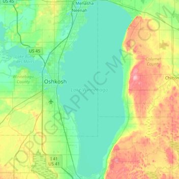
Name: Lake Winnebago topographic map, elevation, terrain.
Location: Lake Winnebago, Fond du Lac County, Wisconsin, United States (43.79319 -88.53757 44.20928 -88.29406)
Average elevation: 833 ft
Minimum elevation: 725 ft
Maximum elevation: 1,142 ft
Wisconsin trails, hiking, mountain biking, running and outdoor activities
Other topographic maps
Click on a map to view its topography, its elevation and its terrain.
Madison
United States > Wisconsin > Dane County
The city is sometimes described as The City of Four Lakes, comprising the four successive lakes of the Yahara River: Lake Mendota ("Fourth Lake"), Lake Monona ("Third Lake"), Lake Waubesa ("Second Lake") and Lake Kegonsa ("First Lake"), although Waubesa and Kegonsa are not actually in Madison, but just south…
Average elevation: 948 ft
Lynn
United States > Wisconsin > Clark County
The history of Lynn, Wisconsin is deeply rooted in the early settlement and development of Clark County. Topics covered in the history of Clark County, Wisconsin, include topography, Indians, early government, early settlement, politics, lumbering, transportation, agriculture, education, the press, the courts,…
Average elevation: 1,165 ft
Northern Wisconsin State Fairgrounds
United States > Wisconsin > Chippewa County > Chippewa Falls
Average elevation: 915 ft
Cleghorn
United States > Wisconsin > Eau Claire County > Town of Pleasant Valley
Average elevation: 1,007 ft
Kickapoo River State Wildlife Area
United States > Wisconsin > Crawford County > Bell Center
Average elevation: 820 ft
Grafton Centennial Park
United States > Wisconsin > Ozaukee County > Grafton
Average elevation: 761 ft
Mississippi River
United States > Wisconsin > Grant County > Dubuque
The uppermost lock and dam on the Upper Mississippi River is the Upper St. Anthony Falls Lock and Dam in Minneapolis. Above the dam, the river's elevation is 799 feet (244 m). Below the dam, the river's elevation is 750 feet (230 m). This 49-foot (15 m) drop is the largest of all the Mississippi River locks…
Average elevation: 666 ft
Mount Hellen
United States > Wisconsin > Saint Croix County > Town of Saint Joseph
Average elevation: 925 ft
Johnstown Center
United States > Wisconsin > Rock County > Town of Johnstown
Average elevation: 951 ft