
Ozette Lake topographic map
Interactive map
Click on the map to display elevation.
About this map
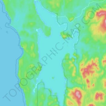
Name: Ozette Lake topographic map, elevation, terrain.
Location: Ozette Lake, Clallam County, Washington, United States (48.03670 -124.66950 48.15325 -124.59600)
Average elevation: 144 ft
Minimum elevation: -16 ft
Maximum elevation: 830 ft
Washington trails, hiking, mountain biking, running and outdoor activities
Other topographic maps
Click on a map to view its topography, its elevation and its terrain.
Snoqualmie Pass
United States > Washington > King County
Due to its elevation, Snoqualmie Pass experiences significantly lower temperatures than Seattle, and receives much more precipitation, much of it being snow. Snoqualmie Pass has a humid continental climate (Koppen: Dsb bordering Csb) with cold, very wet and snowy winters, and mild to warm, relatively dry…
Average elevation: 3,438 ft
Aberdeen
United States > Washington > Grays Harbor County > Aberdeen
Aberdeen is at the eastern end of Grays Harbor, near the mouth of the Chehalis River and southwest of the Olympic Mountains. Grays Harbor is notable as the northernmost ria on North America's Pacific Coast because it has remained free of glaciers throughout the Quaternary due to unfavorable topography and warm…
Average elevation: 217 ft
Mount Si
United States > Washington > King County
The peak can be accessed by two trails. The Old Mount Si trail is accessed by the Little Si parking lot and the Boulder Garden Loop. It is 0.6 miles (0.97 km) shorter, 270 feet (82 m) steeper in elevation gain, and less crowded than the main trail. The Mount Si trail is accessed by the Mount Si parking lot.
Average elevation: 2,582 ft
Hyak
United States > Washington > Kittitas County
Hyak is located two miles (3 km) east of the summit of Snoqulamie Pass at an elevation of 2,600 feet (790 m). It is 16 miles (26 km) northwest of Easton and is part of the Easton school district.
Average elevation: 2,976 ft
Liberty Bell Mountain
United States > Washington > Chelan County
It is a well-known peak in Washington, although it lacks high prominence and elevation. It is well known for having high-quality alpine climbing, with a short approach since the completion of The Washington Pass Highway. A mixture of high-quality granite and difficult rock has made it a very popular weekend…
Average elevation: 6,017 ft
Wind River Arboretum
United States > Washington > Skamania County > Hemlock
Average elevation: 1,309 ft
Ebey's Landing National Historical Reserve
United States > Washington > Island County
Average elevation: 82 ft
Manitou Beach Park
United States > Washington > Kitsap County > Bainbridge Island
Average elevation: 89 ft
Ellensburg
United States > Washington > Kittitas County > Ellensburg > Ellensburg
Average elevation: 1,591 ft
Fritz Hedges Waterway Park
United States > Washington > King County > Seattle
Average elevation: 105 ft