
Oven Creek topographic map
Interactive map
Click on the map to display elevation.
About this map
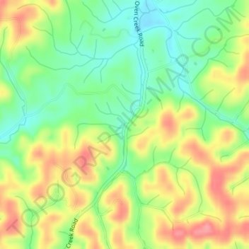
Name: Oven Creek topographic map, elevation, terrain.
Location: Oven Creek, Cocke County, Tennessee, 37868, United States (36.03654 -83.08230 36.03697 -83.08201)
Average elevation: 1,286 ft
Minimum elevation: 1,152 ft
Maximum elevation: 1,444 ft
Tennessee trails, hiking, mountain biking, running and outdoor activities
Other topographic maps
Click on a map to view its topography, its elevation and its terrain.
Monteagle
United States > Tennessee > Grundy County
The town straddles a narrow stretch of the Cumberland Plateau known colloquially as "Monteagle Mountain". This stretch of the plateau is approximately 2 miles (3 km) wide, with steep drop-offs to the northwest and southeast. Monteagle lies at an elevation of just under 2,000 feet (610 m) above sea level. By…
Average elevation: 1,598 ft
Townsend
United States > Tennessee > Blount County
Just to the north and west of Townsend, the Foothills Parkway is a national parkway that traverses Chilhowee Mountain and offers multiple scenic overlooks at high elevations, with views of the Smokies to the south and the Tennessee Valley and Cumberland Plateau to the north and west. As of 2016, road…
Average elevation: 1,234 ft
Elizabethton
United States > Tennessee > Carter County > Elizabethton > Elizabethton
The elevation at Elizabethton Municipal Airport is 1,593 feet (486 m) ASL (the highest point of elevation in Carter County is at Roan Mountain with an elevation of 6,285 feet (1,916 m) ASL), and the airport is located on the eastern side of the city along State Highway 91 Stoney Creek Exit. Elizabethton is…
Average elevation: 1,729 ft
McMinnville
United States > Tennessee > Warren County
According to the United States Census Bureau, the city has a total area of 10.0 square miles (26 km2), all land. McMinnville lies at an elevation of 968 feet (295 m), as it sits along the Eastern Highland Rim near the base of the Cumberland Plateau. The city is drained primarily by the Barren Fork, a tributary…
Average elevation: 991 ft
Greene County
According to the U.S. Census Bureau, the county has a total area of 624 square miles (1,620 km2), of which 622 square miles (1,610 km2) is land and 2.0 square miles (5.2 km2) (0.3%) is water. Most of Greene County is located within the Ridge-and-Valley Appalachians, a range characterized by long, narrow ridges…
Average elevation: 1,611 ft
Morrison Springs
United States > Tennessee > Hamilton County > Chattanooga > Red Bank
Average elevation: 1,073 ft
West Tennessee
West Tennessee is located almost entirely within the Mississippi Embayment, part of the Gulf Coastal Plain. Because of this, the terrain is flatter than the eastern parts of the state. Areas along the Mississippi River are located within the Mississippi Alluvial Plain, which is primarily a floodplain with many…
Average elevation: 417 ft
Glenwood
United States > Tennessee > Hamilton County > Chattanooga > Ridgeside
Average elevation: 751 ft
Eastdale
United States > Tennessee > Hamilton County > Chattanooga > Ridgeside
Average elevation: 778 ft
Whites Creek
United States > Tennessee > Davidson County > Nashville-Davidson
Average elevation: 591 ft
Alpine Heights
United States > Tennessee > Hamilton County > Chattanooga > Red Bank
Average elevation: 817 ft
Colewood Acres
United States > Tennessee > Davidson County > Nashville-Davidson
Average elevation: 604 ft
Spring Valley
United States > Tennessee > Hamilton County > Chattanooga > Red Bank
Average elevation: 1,047 ft
Staffordtown
United States > Tennessee > Polk County > Copperhill
Staffordtown is situated in the scenic Appalachian region, characterized by its rugged terrain and lush forests. The area is marked by steep hills and rolling valleys that define the landscape, with elevations ranging from around 1,500 to 3,000 feet above sea level. The surrounding mountains, part of the…
Average elevation: 1,568 ft