
Death Valley Playa topographic map
Interactive map
Click on the map to display elevation.
About this map
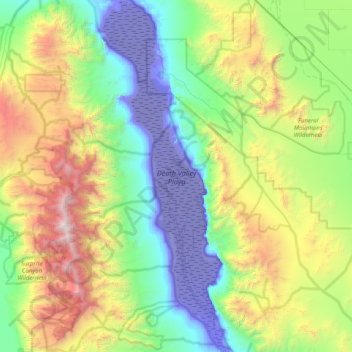
Name: Death Valley Playa topographic map, elevation, terrain.
Location: Death Valley Playa, Inyo County, California, United States (35.93852 -117.00568 36.58476 -116.71460)
Average elevation: 2,881 ft
Minimum elevation: -272 ft
Maximum elevation: 10,974 ft
Inyo County trails, hiking, mountain biking, running and outdoor activities
Other topographic maps
Click on a map to view its topography, its elevation and its terrain.
Round Valley
United States > California > Inyo County
Round Valley is a census-designated place (CDP) in Inyo County, California, United States. Round Valley is located 7.5 miles (12 km) northeast of Mount Tom, at an elevation of 4692 feet (1430 m). The population was 435 at the 2010 census, up from 278 at the 2000 census.
Average elevation: 4,892 ft
Charleston View
United States > California > Inyo County
Charleston View, formally known as Calvada Springs, is an unincorporated community in Inyo County, California. It lies at an elevation of 2621 feet (799 m). The Charleston View CDP had a population of 45 in the 2020 census
Average elevation: 2,631 ft
Big Pine
United States > California > Inyo County
Big Pine (formerly Bigpine) is a census-designated place (CDP) in Inyo County, California, United States. Big Pine is located approximately 15 miles (24 km) south-southeast of Bishop, at an elevation of 3,989 feet (1,216 m). The population was 1,756 at the 2010 census, up from 1,350 at the 2000 census. The Big…
Average elevation: 4,042 ft
Independence
United States > California > Inyo County
Independence is a census-designated place in Inyo County, California. Independence is located 41 miles (66 km) south-southeast of Bishop, at an elevation of 3930 feet (1198 m). It is the county seat of Inyo County, California. The population of this census-designated place was 669 at the 2010 census, up from…
Average elevation: 3,970 ft
Alabama Hills
United States > California > Inyo County
Alabama Hills is an unincorporated community in the Alabama Hills, in Inyo County, California.[1] It lies at an elevation of 4534 feet (1382 m).[1] The community was named after the CSS Alabama.[2]
Average elevation: 4,682 ft