
Savannah River topographic map
Interactive map
Click on the map to display elevation.
About this map
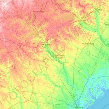
Name: Savannah River topographic map, elevation, terrain.
Location: Savannah River, South Carolina, United States (32.03466 -82.85581 34.44390 -80.84834)
Average elevation: 285 ft
Minimum elevation: -13 ft
Maximum elevation: 958 ft
South Carolina trails, hiking, mountain biking, running and outdoor activities
Other topographic maps
Click on a map to view its topography, its elevation and its terrain.
Royal Pines Country Club Estates
United States > South Carolina > Beaufort County
Average elevation: 23 ft
South Carolina Noname 12005 D-0209 Dam
United States > South Carolina > Chester County > Mountain Lakes
Average elevation: 489 ft
Evergreen Place
United States > South Carolina > Greenville County > Greenville
Average elevation: 945 ft
Kalmia Place
United States > South Carolina > Darlington County > Hartsville
Average elevation: 220 ft
Leesville
United States > South Carolina > Lexington County > Batesburg-Leesville
Average elevation: 623 ft
Battle of Camden National Historic Landmark
United States > South Carolina > Kershaw County > Flat Rock
Average elevation: 341 ft
Sassafras Mountain
United States > South Carolina > Pickens County
The Pisgah Quadrangle topographical map, revised 1904–1905, shows the long abandoned Sassafras Gap Road to be the preferred route through to Rosman, N.C. and Brevard, N.C. at the end of the 19th century and that the existing Highway 178 was then a secondary road. This abandoned road is a short distance from…
Average elevation: 2,936 ft
Naval Nuclear Power Training Command
United States > South Carolina > Berkeley County > Goose Creek
Average elevation: 16 ft
Palmetto Dunes
United States > South Carolina > Beaufort County > Hilton Head Island
Average elevation: 10 ft
Morningside
United States > South Carolina > Greenville County > Wade Hampton
Average elevation: 984 ft
Forest I At Harbison
United States > South Carolina > Richland County > Columbia
Average elevation: 285 ft
Hobcaw Point
United States > South Carolina > Charleston County > Mount Pleasant
Average elevation: 13 ft
Dawson Park
United States > South Carolina > Pickens County > Clemson > Briarwood
Average elevation: 764 ft
Wachesaw Landing
United States > South Carolina > Georgetown County > Murrells Inlet
Average elevation: 13 ft