
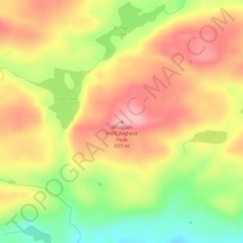
Misquah Hills, highest Peak topographic map
Interactive map
Click on the map to display elevation.
About this map
Name: Misquah Hills, highest Peak topographic map, elevation, terrain.
Average elevation: 2,051 ft
Minimum elevation: 1,798 ft
Maximum elevation: 2,244 ft
Minnesota trails, hiking, mountain biking, running and outdoor activities
Other topographic maps
Click on a map to view its topography, its elevation and its terrain.
Big Bog State Recreation Area
United States > Minnesota > Beltrami County > Waskish
Average elevation: 1,178 ft
Rock County
Rock County is located at the southwestern corner of Minnesota. Its western border shares a boundary with the eastern border of South Dakota, while its southern border is adjacent to the northern border of Iowa. The county is characterized by the flow of the Rock River, which runs southward through its east…
Average elevation: 1,539 ft
Upper Mississippi River National Wildlife & Fish Refuge - Weaver Landing
United States > Minnesota > Wabasha County > Weaver
Average elevation: 705 ft
Murray County
The county terrain consists of low rolling hills, dotted with lakes and ponds, with all available area devoted to agriculture. The terrain slopes to the south and east. However, its highest elevation occurs on Buffalo Ridge, a promontory extending about two miles along the crest of the Coteau des Prairies in…
Average elevation: 1,591 ft
Red Wing
United States > Minnesota > Goodhue County
According to the United States Census Bureau, the city has an area of 41.19 square miles (106.68 km2), of which 34.60 square miles (89.61 km2) is land and 6.59 square miles (17.07 km2) is water. The city is at the northern edge of the Driftless Area of karst topography.
Average elevation: 863 ft
Wilmont
United States > Minnesota > Nobles County
According to the United States Census Bureau, the city has a total area of 1.14 square miles (2.95 km2), all land. By elevation, Wilmont is the highest incorporated community in Nobles County.
Average elevation: 1,729 ft
Hazeltine Lake
United States > Minnesota > Carver County > Chaska > Hazeltine
Average elevation: 945 ft
West Battle Lake
United States > Minnesota > Otter Tail County > Battle Lake
Average elevation: 1,352 ft
Gervais Lake Beach
United States > Minnesota > Ramsey County > Little Canada
Average elevation: 896 ft
Kittson County
Kittson County was once part of glacial Lake Agassiz. Evidence of this prehistoric lake can still be seen in the county's topography. Remnants of McCauleyville Beach can be found in the eastern part of the county, an area of sandy soil and sand ridges. Other evidence of the glacier and Lake Agassiz is the…
Average elevation: 902 ft
Hills
United States > Minnesota > Rock County
According to the United States Census Bureau, the city has a total area of 0.54 square miles (1.40 km2); 0.53 square miles (1.37 km2) is land and 0.01 square miles (0.03 km2) is water. The landscape is flat with some gently rolling hills; however, the town's name does not derive from a particular topographical…
Average elevation: 1,460 ft
Boundary Waters Canoe Area Wilderness
United States > Minnesota > Lake County
Average elevation: 1,388 ft