
Sky Pond topographic map
Interactive map
Click on the map to display elevation.
About this map
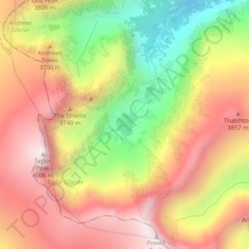
Name: Sky Pond topographic map, elevation, terrain.
Location: Sky Pond, Larimer County, Colorado, United States (40.27676 -105.67047 40.27915 -105.66732)
Average elevation: 11,847 ft
Minimum elevation: 10,203 ft
Maximum elevation: 13,173 ft
Larimer County trails, hiking, mountain biking, running and outdoor activities
Other topographic maps
Click on a map to view its topography, its elevation and its terrain.
Estes Park
United States > Colorado > Larimer County
Estes Park sits at an elevation of 7,522 feet (2,293 m) on the front range of the Rocky Mountains at the eastern entrance of the Rocky Mountain National Park. Its location is 40°22′22″N 105°31′09″W / 40.372856°N 105.519136°W / 40.372856; -105.519136. Its north, south and east extremities…
Average elevation: 7,904 ft
Hallett Peak
United States > Colorado > Larimer County
According to the Köppen climate classification system, Hallett Peak is located in an alpine subarctic climate zone with cold, snowy winters, and cool to warm summers. Due to its altitude, it receives precipitation all year, as snow in winter and as thunderstorms in summer, with a dry period in late spring.
Average elevation: 11,736 ft
Stanley Heights Subdivision
United States > Colorado > Larimer County > Estes Park
Average elevation: 7,694 ft
Lake Estes
United States > Colorado > Larimer County > Estes Park > Stanley Heights Subdivision
Average elevation: 7,605 ft
Estes Park
United States > Colorado > Larimer County
Estes Park sits at an elevation of 7,522 feet (2,293 m) on the front range of the Rocky Mountains at the eastern entrance of the Rocky Mountain National Park. Its location is 40°22′22″N 105°31′09″W / 40.372856°N 105.519136°W / 40.372856; -105.519136. Its north, south and east extremities…
Average elevation: 8,343 ft
Fossil Creek Park
United States > Colorado > Larimer County > Fort Collins
Average elevation: 4,957 ft
Estes Park
United States > Colorado > Larimer County > Estes Park > Estes Park
Average elevation: 8,074 ft
Browns Corner
United States > Colorado > Larimer County > Loveland > Browns Corner
Average elevation: 4,980 ft