
Aspen Grove topographic map
Interactive map
Click on the map to display elevation.
About this map
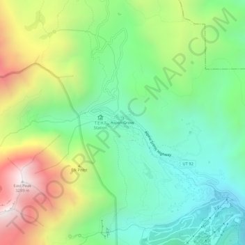
Name: Aspen Grove topographic map, elevation, terrain.
Location: Aspen Grove, Utah County, Utah, United States (40.38414 -111.62151 40.42414 -111.58151)
Average elevation: 7,736 ft
Minimum elevation: 6,089 ft
Maximum elevation: 10,764 ft
Utah County trails, hiking, mountain biking, running and outdoor activities
Other topographic maps
Click on a map to view its topography, its elevation and its terrain.
Utah Lake
United States > Utah > Utah County
Utah Lake is a shallow freshwater lake in the center of Utah County, Utah, United States. It lies in Utah Valley, surrounded by the Provo-Orem metropolitan area. The lake's only river outlet, the Jordan River, is a tributary of the Great Salt Lake. Evaporation accounts for 42% of the lake's outflow, which…
Average elevation: 4,961 ft
Saratoga Springs Park
United States > Utah > Utah County > Saratoga Springs > Saratoga Resort
Average elevation: 4,511 ft
Lone Peak Wilderness
United States > Utah > Utah County > Alpine
The Lone Peak Wilderness provides a spectacular backdrop for the growing urban areas along the Wasatch Front and is dominated by rugged terrain, narrow canyons and high peaks, including the Pfeifferhorn, commonly referred to as Little Matterhorn Peak, at 11,326 feet (3,452 m) and Lone Peak at 11,253 feet…
Average elevation: 7,766 ft