
Make a donation
Gear up for your next adventure:
As an Amazon Associate, this site earns from qualifying purchases at no extra cost to you.
Jake's Rocks topographic map
Click on the map to display elevation.
Make a donation
Gear up for your next adventure:
As an Amazon Associate, this site earns from qualifying purchases at no extra cost to you.
About this map
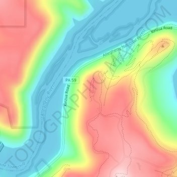
Name: Jake's Rocks topographic map, elevation, terrain.
Average elevation: 1,657 ft
Minimum elevation: 1,309 ft
Maximum elevation: 2,136 ft
Pennsylvania trails, hiking, mountain biking, running and outdoor activities
Make a donation
Gear up for your next adventure:
As an Amazon Associate, this site earns from qualifying purchases at no extra cost to you.
Other topographic maps
Click on a map to view its topography, its elevation and its terrain.
Somerset
United States > Pennsylvania > Somerset County
Somerset has the ninth-highest elevation of towns in Pennsylvania, at 2,190 feet (670 m) above sea level. Somerset County is in Appalachia.
Average elevation: 2,172 ft
Export
United States > Pennsylvania > Westmoreland County
Export is characterized by a varied terrain that reflects its location in the Allegheny Plateau region. The borough sits at an average elevation of around 1,122 feet (342 meters) and features rolling hills and valleys typical of southwestern Pennsylvania's topography. The surrounding landscape is marked by…
Average elevation: 1,122 ft
Lake Ontelaunee Dam
United States > Pennsylvania > Berks County > Ontelaunee Township
Average elevation: 325 ft
Chestnut Hill
United States > Pennsylvania > Philadelphia County > Philadelphia
The village of Chestnut Hill was part of the German Township laid out by Francis Daniel Pastorius and came to include the settlements originally known as Sommerhausen and Crefeld, as well as part of Cresheim. It served as a gateway between Philadelphia and the nearby farmlands. During the American…
Average elevation: 318 ft
Make a donation
Gear up for your next adventure:
As an Amazon Associate, this site earns from qualifying purchases at no extra cost to you.
Make a donation
Gear up for your next adventure:
As an Amazon Associate, this site earns from qualifying purchases at no extra cost to you.
Make a donation
Gear up for your next adventure:
As an Amazon Associate, this site earns from qualifying purchases at no extra cost to you.
Sanatoga
United States > Pennsylvania > Montgomery County > Lower Pottsgrove Township > Sanatoga
Average elevation: 279 ft
Make a donation
Gear up for your next adventure:
As an Amazon Associate, this site earns from qualifying purchases at no extra cost to you.
Make a donation
Gear up for your next adventure:
As an Amazon Associate, this site earns from qualifying purchases at no extra cost to you.
Make a donation
Gear up for your next adventure:
As an Amazon Associate, this site earns from qualifying purchases at no extra cost to you.
Make a donation
Gear up for your next adventure:
As an Amazon Associate, this site earns from qualifying purchases at no extra cost to you.
Connellsville Township
United States > Pennsylvania > Fayette County
Connellsville Township is in northern Fayette County and is bordered to the south and west by the Youghiogheny River, the city of Connellsville, and the borough of South Connellsville. Elevations range from 862 feet (263 m) above sea level in the northwestern corner of the township along the Youghiogheny at…
Average elevation: 1,470 ft
Make a donation
Gear up for your next adventure:
As an Amazon Associate, this site earns from qualifying purchases at no extra cost to you.
Make a donation
Gear up for your next adventure:
As an Amazon Associate, this site earns from qualifying purchases at no extra cost to you.
Nittany Valley
United States > Pennsylvania > Clinton County > Porter Township
Nittany Valley is in the western part of the Ridge and Valley province of the Appalachian Mountains. During the Appalachian orogeny, the sedimentary rock layers folded up into the Nittany Arch anticline. The arch was an ancient Himalayan scale mountain that towered above what is now the valley. The oldest rock…
Average elevation: 1,188 ft
Blue Mountain
United States > Pennsylvania > Schuylkill County > West Penn Township
The ridge of Blue Mountain runs for 150 miles (240 km) through Pennsylvania, reaching an elevation of 2,270 feet (690 m) above sea level just north of the Pennsylvania Turnpike, near the borough of Newburg. Most of the ridgecrest, however, only reaches between 1,400 and 1,700 feet (430 and 520 m) in elevation.…
Average elevation: 823 ft
Make a donation
Gear up for your next adventure:
As an Amazon Associate, this site earns from qualifying purchases at no extra cost to you.
Make a donation
Gear up for your next adventure:
As an Amazon Associate, this site earns from qualifying purchases at no extra cost to you.
Port Trevorton
United States > Pennsylvania > Snyder County > Union Township
Average elevation: 531 ft
Make a donation
Gear up for your next adventure:
As an Amazon Associate, this site earns from qualifying purchases at no extra cost to you.
Moosic Lakes
United States > Pennsylvania > Lackawanna County > Jefferson Township
Average elevation: 2,024 ft
Make a donation
Gear up for your next adventure:
As an Amazon Associate, this site earns from qualifying purchases at no extra cost to you.
Lake Wesauking
United States > Pennsylvania > Bradford County > Wysox Township
Average elevation: 1,165 ft
Make a donation
Gear up for your next adventure:
As an Amazon Associate, this site earns from qualifying purchases at no extra cost to you.
Bald Eagle State Park
United States > Pennsylvania > Centre County
Foster Joseph Sayers Reservoir is a 1,730-acre (700 ha) reservoir that was built in 1971 by the U.S. Army Corps of Engineers as part of a flood control project on the Susquehanna River basin. The lake was created by damming Bald Eagle Creek. It stretches upstream for 8 miles (12.87 km) and has 23 miles (37.01…
Average elevation: 951 ft
Make a donation
Gear up for your next adventure:
As an Amazon Associate, this site earns from qualifying purchases at no extra cost to you.
Make a donation
Gear up for your next adventure:
As an Amazon Associate, this site earns from qualifying purchases at no extra cost to you.
Indian Rocks
United States > Pennsylvania > Lancaster County > East Cocalico Township
Average elevation: 528 ft
Make a donation
Gear up for your next adventure:
As an Amazon Associate, this site earns from qualifying purchases at no extra cost to you.
Wyncote
United States > Pennsylvania > Montgomery County > Cheltenham Township > Glenside > Wyncote
Average elevation: 285 ft
Crabtree Creek
United States > Pennsylvania > Westmoreland County > Salem Township > Crabtree
Average elevation: 1,119 ft
Make a donation
Gear up for your next adventure:
As an Amazon Associate, this site earns from qualifying purchases at no extra cost to you.
Make a donation
Gear up for your next adventure:
As an Amazon Associate, this site earns from qualifying purchases at no extra cost to you.
Rosegarden
United States > Pennsylvania > Cumberland County > Upper Allen Township
Average elevation: 469 ft
Make a donation
Gear up for your next adventure:
As an Amazon Associate, this site earns from qualifying purchases at no extra cost to you.
William Penn State Forest
United States > Pennsylvania > Chester County > West Nottingham Township
Average elevation: 476 ft
Make a donation
Gear up for your next adventure:
As an Amazon Associate, this site earns from qualifying purchases at no extra cost to you.
Make a donation
Gear up for your next adventure:
As an Amazon Associate, this site earns from qualifying purchases at no extra cost to you.
Make a donation
Gear up for your next adventure:
As an Amazon Associate, this site earns from qualifying purchases at no extra cost to you.
Make a donation
Gear up for your next adventure:
As an Amazon Associate, this site earns from qualifying purchases at no extra cost to you.
Englewood
United States > Pennsylvania > Schuylkill County > Butler Township
Average elevation: 1,470 ft
Susquehanna State Park
United States > Pennsylvania > Lycoming County > Williamsport
Average elevation: 676 ft
Make a donation
Gear up for your next adventure:
As an Amazon Associate, this site earns from qualifying purchases at no extra cost to you.