
Make a donation
Gear up for your next adventure:
As an Amazon Associate, this site earns from qualifying purchases at no extra cost to you.
Sixberry Lake topographic map
Click on the map to display elevation.
Make a donation
Gear up for your next adventure:
As an Amazon Associate, this site earns from qualifying purchases at no extra cost to you.
About this map
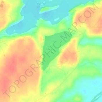
Name: Sixberry Lake topographic map, elevation, terrain.
Location: Sixberry Lake, Jefferson County, New York, United States (44.27346 -75.77967 44.28416 -75.76812)
Average elevation: 381 ft
Minimum elevation: 289 ft
Maximum elevation: 469 ft
New York trails, hiking, mountain biking, running and outdoor activities
Make a donation
Gear up for your next adventure:
As an Amazon Associate, this site earns from qualifying purchases at no extra cost to you.
Other topographic maps
Click on a map to view its topography, its elevation and its terrain.
Catskill Park
New York's wilderness areas must be composed of 10,000 acres (4,000 ha; 40 km2) of contiguous land, twice the federal standard. Land is to be left as "untrammeled by man" and as close to its natural state as possible, offering outstanding opportunities for solitude. No artificially-powered devices are…
Average elevation: 1,644 ft
Troy
United States > New York > Rensselaer County
The western edge of the city is flat along the river, and then steeply slopes to higher terrain to the east. The average elevation is 50 feet, with the highest elevation being 500 feet in the eastern part of the city. The city is longer than it is wide, with the southern part wider than the northern section of…
Average elevation: 449 ft
East Hampton
United States > New York > Suffolk County > East Hampton > Village of East Hampton
Average elevation: 39 ft
Make a donation
Gear up for your next adventure:
As an Amazon Associate, this site earns from qualifying purchases at no extra cost to you.
Watertown
United States > New York > Jefferson County
Watertown is around 60 miles (97 kilometers) northwest of Syracuse, 20 miles (32 kilometers) south of the Thousand Islands and 328 miles (530 kilometers) northwest of New York City. According to the United States Census Bureau, the city has a total area of 9.3 square miles (24 km2), of which 9.0 square miles…
Average elevation: 643 ft
Washington Heights
United States > New York > New York
Because of their abrupt, hilly topography, pedestrian navigation in Upper Manhattan is facilitated by many step streets. The longest of these in Washington Heights, at approximately 130 stairs and with an elevation gain of approximately 65 feet, connects Fort Washington Avenue and Overlook Terrace at 187th…
Average elevation: 82 ft
Saratoga Springs
United States > New York > Saratoga County > Saratoga Springs
Average elevation: 528 ft
Make a donation
Gear up for your next adventure:
As an Amazon Associate, this site earns from qualifying purchases at no extra cost to you.
Manhattan Island
United States > New York > New York
Marble Hill is one example of how Manhattan's land has been considerably altered by human intervention. The borough has seen substantial land reclamation along its waterfronts since Dutch colonial times, and much of the natural variation in its topography has been evened out.
Average elevation: 56 ft
Harriman State Park
United States > New York > Orange County > Town of Tuxedo
Average elevation: 719 ft
Make a donation
Gear up for your next adventure:
As an Amazon Associate, this site earns from qualifying purchases at no extra cost to you.
Make a donation
Gear up for your next adventure:
As an Amazon Associate, this site earns from qualifying purchases at no extra cost to you.
Oneonta
United States > New York > Otsego County > City of Oneonta > Oneonta
Average elevation: 1,467 ft
Village of New Paltz
United States > New York > Ulster County > Town of New Paltz
Average elevation: 276 ft
Make a donation
Gear up for your next adventure:
As an Amazon Associate, this site earns from qualifying purchases at no extra cost to you.
City of Oswego
United States > New York > Oswego County
Oswego is located on the southeastern shore of Lake Ontario at the mouth of the Oswego River, approximately 35 miles north of Syracuse and 69 miles east of Rochester. The elevation is 298 feet above sea level. The nearest city is Fulton, located south of Oswego and north of Syracuse.
Average elevation: 285 ft
Make a donation
Gear up for your next adventure:
As an Amazon Associate, this site earns from qualifying purchases at no extra cost to you.
Port Jefferson Station
United States > New York > Suffolk County > Town of Brookhaven
Average elevation: 157 ft
French Mountain
United States > New York > Warren County > Town of Queensbury
Average elevation: 1,040 ft
Genesee River
Only a small creek (Irondequoit Creek) flows in what is left of this large paleogeologic valley. The area of the lower river was also affected. Since the earth rebounded from the melting glaciers more rapidly in Canada than in New York, water from Lake Ontario was spilled over New York due to its lower…
Average elevation: 1,302 ft
Make a donation
Gear up for your next adventure:
As an Amazon Associate, this site earns from qualifying purchases at no extra cost to you.
Village of Warwick
United States > New York > Orange County > Town of Warwick
Average elevation: 614 ft
Great Sacandaga Lake
United States > New York > Fulton County > Town of Hadley
Average elevation: 1,214 ft
Make a donation
Gear up for your next adventure:
As an Amazon Associate, this site earns from qualifying purchases at no extra cost to you.
Highbridge Park
United States > New York > New York County > New York
The north and south wings respectively contain the women's and men's locker rooms and are nearly identical. Both have nine windows separated by eight brick pilasters. The stone capitals of the pilasters line up with the lintels of the windows. Ramps lead from the extreme ends of each wing. The ground slopes…
Average elevation: 98 ft
Riveredge Trailer Park
United States > New York > Westchester County > Town of Cortlandt > Verplanck
Average elevation: 46 ft
Make a donation
Gear up for your next adventure:
As an Amazon Associate, this site earns from qualifying purchases at no extra cost to you.
Make a donation
Gear up for your next adventure:
As an Amazon Associate, this site earns from qualifying purchases at no extra cost to you.
Make a donation
Gear up for your next adventure:
As an Amazon Associate, this site earns from qualifying purchases at no extra cost to you.
Canadarago Lake
United States > New York > Otsego County > Town of Richfield
It is geologically related to the Finger Lakes, as they were both carved by glaciers, but is not counted among them. One difference is that Canadarago Lake is situated at a higher elevation (1,266 feet [386 m]) than the Finger Lakes (approximately 400 feet [122 m]). Another difference is the Finger Lakes are…
Average elevation: 1,453 ft
East Williamson
United States > New York > Wayne County > Town of Williamson
Average elevation: 436 ft
Make a donation
Gear up for your next adventure:
As an Amazon Associate, this site earns from qualifying purchases at no extra cost to you.
Big Bear Mountain
United States > New York > Warren County > Town of Johnsburg
Average elevation: 2,021 ft
Make a donation
Gear up for your next adventure:
As an Amazon Associate, this site earns from qualifying purchases at no extra cost to you.
Make a donation
Gear up for your next adventure:
As an Amazon Associate, this site earns from qualifying purchases at no extra cost to you.
Robinson Corners
United States > New York > Otsego County > Town of Edmeston
Average elevation: 1,398 ft
Storm King State Park
United States > New York > Orange County > Town of Cornwall > Village of Cornwall-on-Hudson
Average elevation: 640 ft
Make a donation
Gear up for your next adventure:
As an Amazon Associate, this site earns from qualifying purchases at no extra cost to you.
Pecksville
United States > New York > Dutchess County > Town of East Fishkill
Average elevation: 899 ft
Make a donation
Gear up for your next adventure:
As an Amazon Associate, this site earns from qualifying purchases at no extra cost to you.
Rotterdam Junction
United States > New York > Schenectady County > Town of Rotterdam
Average elevation: 531 ft
Titicus Reservoir
United States > New York > Westchester County > Town of North Salem > Salem Center
Average elevation: 420 ft
Make a donation
Gear up for your next adventure:
As an Amazon Associate, this site earns from qualifying purchases at no extra cost to you.
Millers Corners
United States > New York > Rensselaer County > Town of Nassau
Average elevation: 689 ft
Make a donation
Gear up for your next adventure:
As an Amazon Associate, this site earns from qualifying purchases at no extra cost to you.
Stoodley Corners
United States > New York > Schenectady County > East Glenville
Average elevation: 351 ft
Make a donation
Gear up for your next adventure:
As an Amazon Associate, this site earns from qualifying purchases at no extra cost to you.
Harbor Island Park
United States > New York > Westchester County > Town of Mamaroneck > Orienta
Average elevation: 33 ft
Town of Edmeston
United States > New York > Otsego County
The elevation of the town varies by approximately 800 feet (240 m): from just under 1,100 feet (340 m) above sea level at the Unadilla River in the southwestern corner of the town, to just over 1,900 feet (580 m) at peaks near Taylor Hill and Summit Lake in the northeastern corner.
Average elevation: 1,447 ft
Make a donation
Gear up for your next adventure:
As an Amazon Associate, this site earns from qualifying purchases at no extra cost to you.
Lake Huntington
United States > New York > Sullivan County > Town of Cochecton
Average elevation: 1,250 ft
Make a donation
Gear up for your next adventure:
As an Amazon Associate, this site earns from qualifying purchases at no extra cost to you.
Isle of San Souci
United States > New York > Westchester County > City of New Rochelle
Average elevation: 23 ft
Village of Speculator
United States > New York > Hamilton County > Town of Lake Pleasant
Speculator Mountain, with an altitude of 2,966 feet (904 m), is south of the village.
Average elevation: 2,126 ft
Make a donation
Gear up for your next adventure:
As an Amazon Associate, this site earns from qualifying purchases at no extra cost to you.
Make a donation
Gear up for your next adventure:
As an Amazon Associate, this site earns from qualifying purchases at no extra cost to you.
West Stephentown
United States > New York > Rensselaer County > Town of Stephentown
Average elevation: 1,306 ft
Make a donation
Gear up for your next adventure:
As an Amazon Associate, this site earns from qualifying purchases at no extra cost to you.
Grovenor Corners
United States > New York > Schoharie County > Town of Carlisle
Average elevation: 1,099 ft
Make a donation
Gear up for your next adventure:
As an Amazon Associate, this site earns from qualifying purchases at no extra cost to you.