Genesee River topographic map
Interactive map
Click on the map to display elevation.
About this map
![Genesee River topographic map, elevation, terrain](/pub/maps/relation/fgkl/flpwb3/thumbnail.jpg)
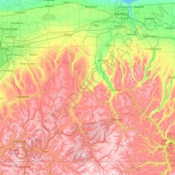
Name: Genesee River topographic map, elevation, terrain.
Location: Genesee River, New York, United States (41.88866 -78.16955 43.26328 -77.59842)
Average elevation: 1,302 ft
Minimum elevation: 240 ft
Maximum elevation: 2,589 ft
Only a small creek (Irondequoit Creek) flows in what is left of this large paleogeologic valley. The area of the lower river was also affected. Since the earth rebounded from the melting glaciers more rapidly in Canada than in New York, water from Lake Ontario was spilled over New York due to its lower elevation. During this time, the original outlet of the Genesee River, Irondequoit Bay, was flooded out, creating the current bay. As these waters later retreated, glacial debris caused the river to be rerouted to the west along its current path.
Other topographic maps
Click on a map to view its topography, its elevation and its terrain.
![Manhattan topographic map, elevation, terrain](/pub/maps/relation/f5mt/4gpg3q/icon.jpg)
Manhattan
United States > New York > New York County > New York
Manhattan, New York County, New York, United States
Average elevation: 52 ft
![Lake George topographic map, elevation, terrain](/pub/maps/relation/c257/vpltj/icon.jpg)
Lake George
United States > New York > Warren County > Town of Bolton
Lake George, Town of Bolton, Warren County, New York, United States
Average elevation: 810 ft
![Adirondack Park topographic map, elevation, terrain](/pub/maps/relation/psrr/fbqm4s/icon.jpg)
Adirondack Park
Adirondack Park, New York, United States
Average elevation: 1,217 ft
![Buffalo topographic map, elevation, terrain](/pub/maps/relation/1j3q/l3mgp/icon.jpg)
Buffalo
United States > New York > Erie County
Buffalo, Erie County, New York, United States
Average elevation: 607 ft
![Staten Island topographic map, elevation, terrain](/pub/maps/relation/dgkl/51gxf3/icon.jpg)
Staten Island
United States > New York > New York
Staten Island, Richmond County, New York, United States
Average elevation: 30 ft
![City of Ithaca topographic map, elevation, terrain](/pub/maps/relation/93tf/mhv51/icon.jpg)
City of Ithaca
United States > New York > Tompkins County
City of Ithaca, Tompkins County, New York, United States
Average elevation: 640 ft
![Montauk topographic map, elevation, terrain](/pub/maps/relation/s2tp/tnzcz/icon.jpg)
Montauk
United States > New York > Suffolk County > Town of East Hampton
Montauk, Town of East Hampton, Suffolk County, New York, 11954, United States
Average elevation: 7 ft
![City of Syracuse topographic map, elevation, terrain](/pub/maps/relation/7hzs/smngt/icon.jpg)
City of Syracuse
United States > New York > Onondaga County
City of Syracuse, Onondaga County, New York, United States
Average elevation: 564 ft
![Finger Lakes National Forest topographic map, elevation, terrain](/pub/maps/relation/xtzs/jpx3s8/icon.jpg)
Finger Lakes National Forest
United States > New York > Schuyler County > Town of Hector
Finger Lakes National Forest, Town of Hector, Schuyler County, New York, 14818, United States
Average elevation: 1,168 ft
![Manhattan Island topographic map, elevation, terrain](/pub/maps/relation/7z4s/h9p351/icon.jpg)
Manhattan Island
United States > New York > New York
Manhattan Island, New York, United States
Average elevation: 56 ft
![Putnam County topographic map, elevation, terrain](/pub/maps/relation/j1t6/szxjs8/icon.jpg)
Putnam County
Putnam County, New York, United States
Average elevation: 554 ft
![Tompkins County topographic map, elevation, terrain](/pub/maps/relation/9j18/d2bckl/icon.jpg)
Tompkins County
Tompkins County, New York, United States
Average elevation: 1,237 ft
![East Windsor topographic map, elevation, terrain](/pub/maps/node/1hcz/dzv8d14/icon.jpg)
East Windsor
United States > New York > Broome County
East Windsor, Town of Windsor, Broome County, New York, 13826, United States
Average elevation: 1,240 ft
![Dutchess County topographic map, elevation, terrain](/pub/maps/relation/f9mt/84bpz4/icon.jpg)
Dutchess County
Dutchess County, New York, United States
Average elevation: 587 ft
![Westchester County topographic map, elevation, terrain](/pub/maps/relation/7b14/9tzv57/icon.jpg)
Westchester County
Westchester County, New York, United States
Average elevation: 312 ft
![East Hampton topographic map, elevation, terrain](/pub/maps/node/vtm2/v7ldttj/icon.jpg)
East Hampton
United States > New York > Suffolk County > East Hampton > Village of East Hampton
East Hampton, Village of East Hampton, Suffolk County, New York, 11937, United States
Average elevation: 39 ft
![Village of New Paltz topographic map, elevation, terrain](/pub/maps/relation/s8mt/j5z5k/icon.jpg)
Village of New Paltz
United States > New York > Ulster County > Town of New Paltz
Village of New Paltz, Town of New Paltz, Ulster County, New York, 12561, United States
Average elevation: 276 ft
![City of Kingston topographic map, elevation, terrain](/pub/maps/relation/hr51/fsm1h/icon.jpg)
City of Kingston
United States > New York > Ulster County
City of Kingston, Ulster County, New York, 12401, United States
Average elevation: 171 ft
![Cortland County topographic map, elevation, terrain](/pub/maps/relation/xqb3/frgq4s/icon.jpg)
Cortland County
Cortland County, New York, United States
Average elevation: 1,486 ft
![Town of Danby topographic map, elevation, terrain](/pub/maps/relation/pr3q/g45818/icon.jpg)
Town of Danby
United States > New York > Tompkins County
Town of Danby, Tompkins County, New York, United States
Average elevation: 1,325 ft
![East Ithaca topographic map, elevation, terrain](/pub/maps/relation/lt14/97l4s/icon.jpg)
East Ithaca
United States > New York > Tompkins County > Town of Ithaca
East Ithaca, Town of Ithaca, Tompkins County, New York, United States
Average elevation: 925 ft
![North Church Corner topographic map, elevation, terrain](/pub/maps/node/784s/jml495k/icon.jpg)
North Church Corner
United States > New York > Oswego County > Town of Mexico
North Church Corner, Town of Mexico, Oswego County, New York, 13114, United States
Average elevation: 308 ft
![Village of Phelps topographic map, elevation, terrain](/pub/maps/relation/hprr/76xs8/icon.jpg)
Village of Phelps
United States > New York > Ontario County
Village of Phelps, Town of Phelps, Ontario County, New York, United States
Average elevation: 535 ft
![San Remo topographic map, elevation, terrain](/pub/maps/node/xrzs/lzb1cgp/icon.jpg)
San Remo
United States > New York > Suffolk County > Smithtown
San Remo, Smithtown, Town of Smithtown, Suffolk County, New York, 11754, United States
Average elevation: 95 ft
![Clinton, NY topographic map, elevation, terrain](/pub/maps/way/dv4s/spq5zf3/icon.jpg)
Clinton, NY
United States > New York > Oneida County > Town of Kirkland > Village of Clinton
Clinton, NY, Village of Clinton, Town of Kirkland, Oneida County, New York, United States
Average elevation: 623 ft
![Quarryville topographic map, elevation, terrain](/pub/maps/node/z2nx/625v39m/icon.jpg)
Quarryville
United States > New York > Ulster County > Town of Saugerties
Quarryville, Town of Saugerties, Ulster County, New York, 12477, United States
Average elevation: 325 ft
![Town of Huntington topographic map, elevation, terrain](/pub/maps/relation/hr3q/n58jt6/icon.jpg)
Town of Huntington
United States > New York > Suffolk County
Town of Huntington, Suffolk County, New York, United States
Average elevation: 98 ft
![Town of Vestal topographic map, elevation, terrain](/pub/maps/relation/fvkl/xr6xtf/icon.jpg)
Town of Vestal
United States > New York > Broome County
Town of Vestal, Broome County, New York, United States
Average elevation: 1,220 ft
![Town of Catskill topographic map, elevation, terrain](/pub/maps/relation/gg57/pdb951/icon.jpg)
Town of Catskill
United States > New York > Greene County
Town of Catskill, Greene County, New York, United States
Average elevation: 194 ft
![Upper West Side topographic map, elevation, terrain](/pub/maps/relation/7j14/62frmt/icon.jpg)
Upper West Side
United States > New York > New York
Upper West Side, Manhattan Community Board 7, Manhattan, New York County, New York, United States
Average elevation: 75 ft
![Town of Clifton Park topographic map, elevation, terrain](/pub/maps/relation/mtmt/nsj9rr/icon.jpg)
Town of Clifton Park
United States > New York > Saratoga County
Town of Clifton Park, Saratoga County, New York, United States
Average elevation: 279 ft
![The Bronx topographic map, elevation, terrain](/pub/maps/relation/sks8/lx34rr/icon.jpg)
The Bronx
United States > New York > New York
The Bronx, New York, United States
Average elevation: 75 ft
![Orange County topographic map, elevation, terrain](/pub/maps/relation/l7nh/3q699m/icon.jpg)
Orange County
Orange County, New York, United States
Average elevation: 636 ft
![Brooklyn topographic map, elevation, terrain](/pub/maps/relation/339m/fwsvm2/icon.jpg)
Brooklyn
United States > New York > New York
Brooklyn, Kings County, New York, United States
Average elevation: 30 ft
![Monroe County topographic map, elevation, terrain](/pub/maps/relation/l3z4/k1dct6/icon.jpg)
Monroe County
Monroe County, New York, United States
Average elevation: 400 ft
![Town of Van Etten topographic map, elevation, terrain](/pub/maps/relation/l44s/1xnczs/icon.jpg)
Town of Van Etten
United States > New York > Chemung County
Town of Van Etten, Chemung County, New York, 14889, United States
Average elevation: 1,398 ft
![Town of Clarkson topographic map, elevation, terrain](/pub/maps/relation/mjmt/9dfpkl/icon.jpg)
Town of Clarkson
United States > New York > Monroe County
Town of Clarkson, Monroe County, New York, United States
Average elevation: 410 ft
![Town of Patterson topographic map, elevation, terrain](/pub/maps/relation/dws8/gpk65k/icon.jpg)
Town of Patterson
United States > New York > Putnam County
Town of Patterson, Putnam County, New York, 12563, United States
Average elevation: 663 ft
![Town of Western topographic map, elevation, terrain](/pub/maps/relation/ww18/wwrqt6/icon.jpg)
Town of Western
United States > New York > Oneida County
Town of Western, Oneida County, New York, United States
Average elevation: 1,001 ft
![Village of Johnson City topographic map, elevation, terrain](/pub/maps/relation/dps8/s8tmt/icon.jpg)
Village of Johnson City
United States > New York > Broome County
Village of Johnson City, Town of Union, Broome County, New York, 13790, United States
Average elevation: 1,014 ft
![City of Schenectady topographic map, elevation, terrain](/pub/maps/relation/pdrr/7drs8/icon.jpg)
City of Schenectady
United States > New York > Schenectady County
City of Schenectady, Schenectady County, New York, 12345, United States
Average elevation: 328 ft
![Saratoga Springs topographic map, elevation, terrain](/pub/maps/node/sdmt/9nc784s/icon.jpg)
Saratoga Springs
United States > New York > Saratoga County > Saratoga Springs
Saratoga Springs, City of Saratoga Springs, Saratoga County, New York, 12866, United States
Average elevation: 528 ft
![Village of Lake Placid topographic map, elevation, terrain](/pub/maps/relation/7mb3/nvc3q/icon.jpg)
Village of Lake Placid
United States > New York > Essex County
Village of Lake Placid, Town of North Elba, Essex County, New York, 12946, United States
Average elevation: 1,831 ft
![Oneida County topographic map, elevation, terrain](/pub/maps/relation/rmnx/m575nh/icon.jpg)
Oneida County
Oneida County, New York, United States
Average elevation: 1,086 ft
![City of Rye topographic map, elevation, terrain](/pub/maps/relation/vwcz/kdmf3/icon.jpg)
City of Rye
United States > New York > Westchester County
City of Rye, Westchester County, New York, United States
Average elevation: 30 ft
![City of Yonkers topographic map, elevation, terrain](/pub/maps/relation/3dtp/t1scz/icon.jpg)
City of Yonkers
United States > New York > Westchester County
City of Yonkers, Westchester County, New York, United States
Average elevation: 190 ft