
Loomis topographic map
Interactive map
Click on the map to display elevation.
About this map
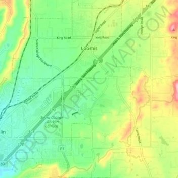
Name: Loomis topographic map, elevation, terrain.
Location: Loomis, Placer County, California, 95650, United States (38.77401 -121.22894 38.83867 -121.17246)
Average elevation: 400 ft
Minimum elevation: 210 ft
Maximum elevation: 732 ft
Placer County trails, hiking, mountain biking, running and outdoor activities
Other topographic maps
Click on a map to view its topography, its elevation and its terrain.
North Tahoe Regional Park
United States > California > Placer County > Tahoe Vista
Average elevation: 6,585 ft
Olympic Valley
United States > California > Placer County > Olympic Valley
Average elevation: 6,896 ft
Carnelian Bay
United States > California > Placer County
For statistical purposes, the United States Census Bureau has defined Carnelian Bay as a census-designated place (CDP). The census definition of the area may not precisely correspond to local understanding of the area with the same name. The population was 524 at the 2010 census. The elevation is 6,325 feet…
Average elevation: 6,486 ft
Blue Canyon
United States > California > Placer County
Blue Canyon (also, Blue Cañon) is an unincorporated community in Placer County, California. Blue Canyon is located 4 miles (6.4 km) southwest of Emigrant Gap. It lies at an elevation of 4695 feet (1431 m).
Average elevation: 4,764 ft