
Albany County topographic map
Interactive map
Click on the map to display elevation.
About this map
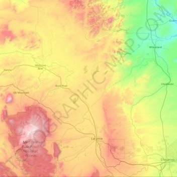
Name: Albany County topographic map, elevation, terrain.
Location: Albany County, Wyoming, United States (40.99702 -106.32508 42.43318 -105.27144)
Average elevation: 7,014 ft
Minimum elevation: 4,341 ft
Maximum elevation: 11,791 ft
Wyoming trails, hiking, mountain biking, running and outdoor activities
Other topographic maps
Click on a map to view its topography, its elevation and its terrain.
Laramie
United States > Wyoming > Albany County
Laramie (/ˈlærəmi/) is a city in and the county seat of Albany County, Wyoming, United States, known for its high elevation at 7,200 feet (2,200 m), railroad history, and is the home of the University of Wyoming. The population was 31,407 at the 2020 census, making it the fourth-most populous city in…
Average elevation: 7,277 ft
Rocky Mountains
United States > Wyoming > Teton County
Agriculture and forestry are major industries. Agriculture includes dryland and irrigated farming and livestock grazing. Livestock are frequently moved between high-elevation summer pastures and low-elevation winter pastures, a practice known as transhumance.
Average elevation: 7,520 ft
Gannett Peak
United States > Wyoming > Fremont County
Gannett Peak is the highest mountain peak in the U.S. state of Wyoming at 13,810 feet (4,210 m). It lies in the Wind River Range within the Bridger Wilderness of the Bridger-Teton National Forest. Straddling the Continental Divide along the boundary between Fremont and Sublette counties, it has the second…
Average elevation: 12,139 ft
World's Largest Mineral Hot Spring
United States > Wyoming > Hot Springs County > Thermopolis
Average elevation: 4,462 ft
Cloud Peak
United States > Wyoming > Big Horn County
It rises to an elevation of 13,171 feet (4,015 m) and provides onlookers with dramatic views and vistas. The mountain can be climbed most easily from the western side, accessed by either the Battle Park or West Tensleep trail-heads and is roughly 24 miles round-trip from both. The peak is located in the…
Average elevation: 11,804 ft
Laramie
United States > Wyoming > Albany County > Laramie
Laramie is on a high plain between two mountain ranges, the Snowy Range, about 30 miles (48 km) to the west, and the Laramie Range, 7 miles (11 km) to the east. The city's elevation above sea level is approximately 7,165 feet (2,184 m). The Laramie River runs through Laramie toward its confluence with the…
Average elevation: 7,543 ft
Casper Mountain
United States > Wyoming > Natrona County
Casper Mountain, an anticline, is located at the north end of the Laramie Mountains overlooking Casper, Wyoming along the North Platte River. At a top elevation of 8,130 feet (2,478 m), the geological feature rises approximately 3,000 feet (914 m) above Casper.
Average elevation: 7,595 ft
Worland
United States > Wyoming > Washakie County > Worland
Worland experiences an arid climate (Köppen BWk), but one which is quite distinct from much of the state. Due to the location within the Big Horn Basin, it is protected from severe weather by the surrounding mountains from nearly every direction. This topography results in weather that is highly continental…
Average elevation: 4,327 ft
Upper Geyser Basin
United States > Wyoming > Teton County > Upper Geyser Basin
Average elevation: 7,530 ft
Pinedale
United States > Wyoming > Sublette County
Pinedale is located at 42°51′58″N 109°51′53″W / 42.86611°N 109.86472°W / 42.86611; -109.86472 (42.866162, −109.864622) and sits at an elevation of 7,175 feet above sea level. According to the United States Census Bureau, the town has a total area of 2.15 square miles (5.57 km2), all of it land.
Average elevation: 7,215 ft