
Jefferson County topographic map
Interactive map
Click on the map to display elevation.
About this map
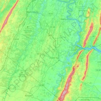
Name: Jefferson County topographic map, elevation, terrain.
Location: Jefferson County, West Virginia, United States (39.13228 -78.03513 39.49927 -77.71903)
Average elevation: 571 ft
Minimum elevation: 217 ft
Maximum elevation: 1,677 ft
West Virginia trails, hiking, mountain biking, running and outdoor activities
Other topographic maps
Click on a map to view its topography, its elevation and its terrain.
Mason-Dixon Historical Park
United States > West Virginia > Monongalia County > Holman
Average elevation: 1,083 ft
White Top
United States > West Virginia > Randolph County
White Top is a knob and spur of Cheat Mountain in southeastern Randolph County, West Virginia, USA. Sitting at an elevation of 4,085 feet (1,245 m), it is located just west of the Shavers Fork of Cheat River and Cheat Bridge. While White Top was originally crossed by the Staunton–Parkersburg Turnpike,…
Average elevation: 3,802 ft
Seneca Rocks
United States > West Virginia > Pendleton County > Seneca Rocks
Average elevation: 2,044 ft
Spruce Knob
United States > West Virginia > Pendleton County
Spruce Mountain, located in eastern West Virginia, is the highest ridge of the Allegheny Mountains. The whale-backed ridge extends for only 16 miles (26 km) from northeast to southwest, but several of its peaks exceed 4,500 feet (1,400 m) in elevation. The summit, Spruce Knob (4,863 ft; 1,482 m), is the…
Average elevation: 4,180 ft
Johnstown
United States > West Virginia > Raleigh County > Beckley > Sprague
Average elevation: 2,326 ft
West Sabraton
United States > West Virginia > Monongalia County > Morgantown
Average elevation: 1,056 ft
West Sabraton
United States > West Virginia > Monongalia County > Morgantown
Average elevation: 1,056 ft
Alderson Recreation Area
United States > West Virginia > Greenbrier County > Alderson
Average elevation: 1,644 ft